


2021 Trips

 1
1
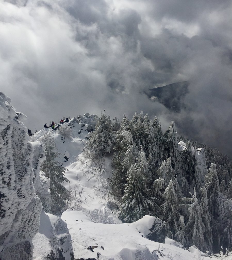
Tiger Mountain Trifecta
8 miles of hiking • 3500' elevation gain •
This used to be one of my favorite close by conditioning hikes, but alas no more. I have not been up there since they logged the 3 summit areas and while it has opened it up for some expansive views it has obliviated many hiking trails that led to the summits, plus now you are forced to hike on a muddy road through clear cuts to traverse between the summits.....yuck!

December 19, 2021
 1
1
December 12, 2021
 1
1
Tiger Mountain
5.63 miles of hiking • 2500' elevation gain •
Section Line trail up to Tiger Summit #3.
December 5, 2021
 1
1
Tiger Mountain
5.89 miles of hiking • 2000' elevation gain •
All 3 of the TM summits are closed to hikers until further notice due to ongoing logging operations.
October 30, 2021
 1
1
October 23, 2021

 1
1
September 11, 2021
 1
1
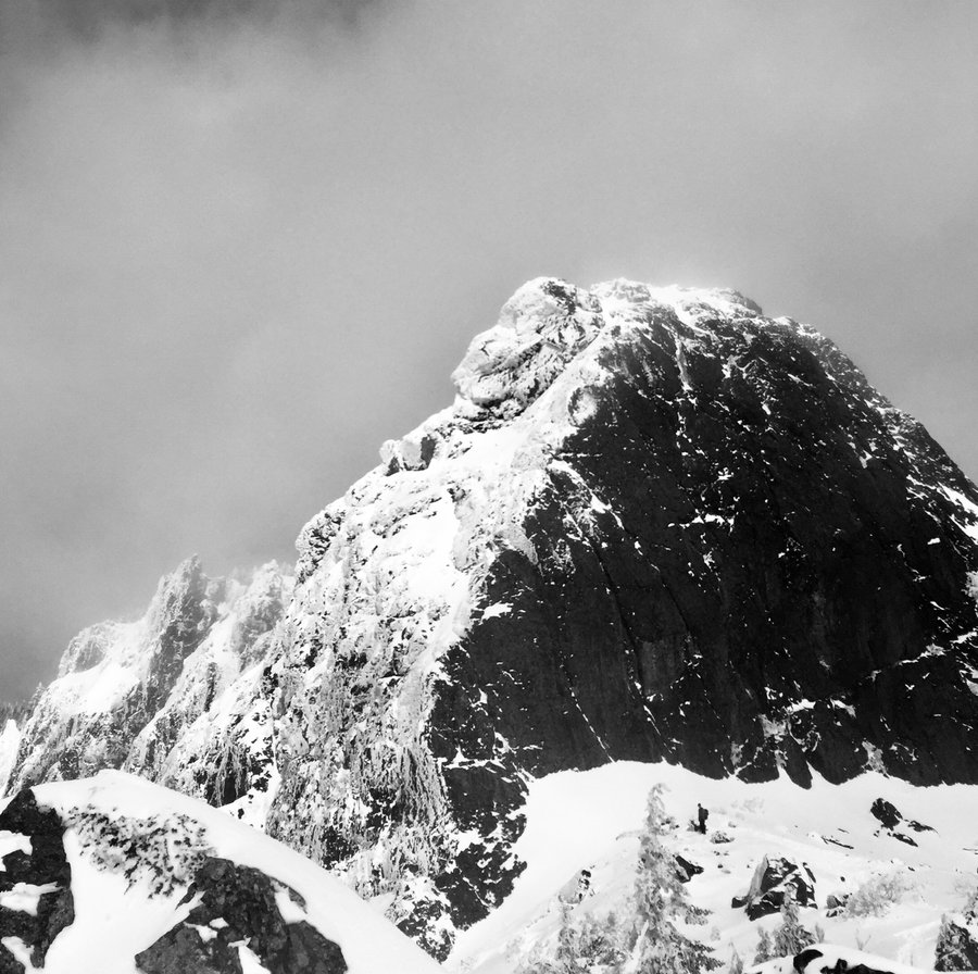
ONP-Constance Pass/Del Monte Ridge
26 miles of hiking • 5500' elevation gain • 2 nights
Entered via the Dungeness River TH. Made base camp around 3.5 miles in at Camp Handy. Did a bit of exploring after dinner down the Heather Creek trail. Next day got up bright and early and hiked up to Boulder Shelter, and then continued on the trail to Home Lake which is within the ONP. Home lake appeared pretty full up with people camping in areas where imo tents should not be placed. From there it was a steep climb up Constance Pass which tops off at 5800' and then up to Del Monte Ridge which tops out at 6400'. Really nice views from the ridge with Mt. Olympus looming to the west and Rainier to the East. Headed back to camp via the same trail and met a lot of people heading to camp at Home Lake. I was surprised that quite a few did not realize that it was a permitted area and that a bear can was required. Maybe I should not be surprised these days....sigh,
August 27 – August 29, 2021
 3
3
Vesper Peak
6.76 miles of hiking • 4000' elevation gain •
First time hiking Vesper peak and all I can say is that this was one tough hike with the eg, hot weather and extremely rocky trail tread. Felt way longer then 7 miles. The final 1/2 mile push to the summit is a 1000' eg scramble which really takes it out of your. But once at Vesper's 6138' summit you momentarily forget the pain and soak in the spectacular views. That is, until you head down and have to negotiate the steep, rocky trail again which had me muttering more then once about my choice of leisure activities.
August 15, 2021
 1
1
Mt. Baker-Upper Wild Goose Trail
2.06 miles of hiking • 500' elevation gain •
The wife and I were on a leisurely car camping trip at Silver Lake by Maple Falls and decided after much napping, sunning and swimming to drive up to Artist Point as my wife had never been up there. I forgot that the road was closed for repairs approx. 2 miles from Artist Point so we hiked the Upper Wild Goose Trail up to AP which was pretty much empty due to the road closure. .
August 4, 2021
 1
1
ONP--Flapjack Lakes & Beyond
22 miles of hiking • 5500' elevation gain • 2 nights
Started trip at the Staircase entrance to ONP and spent a couple nights at the lakes. On day 2 hiked up to Gladys Divide and then up to the summit of Mt. Gladys which had nice views of Mt. Olympus. We attempted to find our way to Black & White Lakes to attempt a loop hike but due to the heat and very annoying bugs headed back to FlapJack for a nice refreshing swim.
July 29 – July 31, 2021
 1
1
ONP--Maiden Peak
9 miles of hiking • 2000' elevation gain •
Began hike at the Deer Park TH. I have attempted this hike before in the spring while camping at Deer Park before the car campground opens but there always was to much snow. No snow this time and we hiked up to Maiden Peak and then a bit further but not quite up to the summit of Elk Mountain.
July 18, 2021
 1
1
Olympics-Charlia Lakes
16 miles of hiking • 4500' elevation gain • 1 night
Entered via Upper Dungeness TH and made camp on the saddle above Charlia Lakes. Spent the next day exploring the ridges, above the lakes.
July 6 – July 7, 2021
 1
1
Olympics- Buckhorn Pass
20.3 miles of hiking • 5000' elevation gain • 1 night
Trying to beat the heat left late Friday morning and reached the The Tubal Cain TH early afternoon. Made camp at my top secret location up by the pass at around 6500'. Very mild temps for this time of year and at this elevation with overnight temps in the low 60's. Rose early the next day and and could tell it was going to be a scorcher and we wanted to get a Buckhorn summit climb in before it got to hot and then take a dip in Buckhorn lake on the hike out. As always the views from the Buckhorn summit on a clear days never disappoint and the quick dip in the lake was icing on the cake.
June 25 – June 26, 2021
 1
1
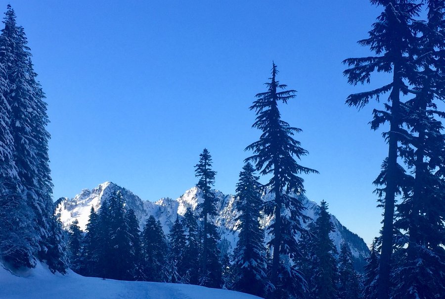
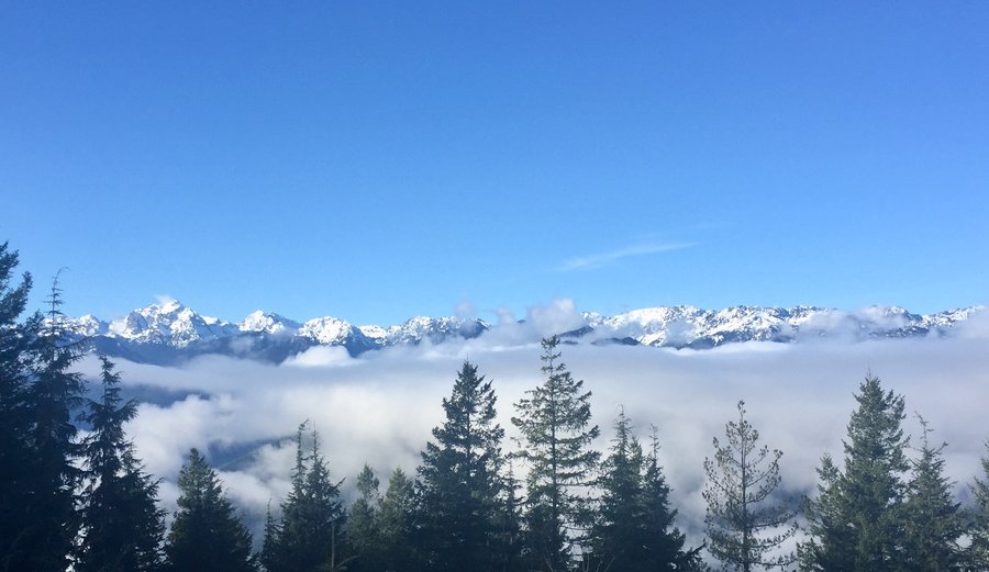
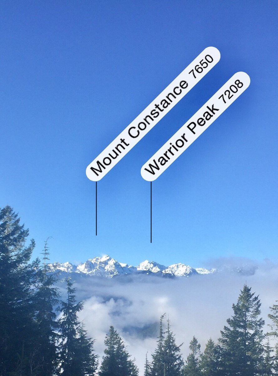
Olympics- Marmot Pass
13 miles of hiking • 4250' elevation gain • 1 night
The Upper Big Quilcene TH was packed when we arrived Friday at 11AM. Appeared there were a lot of first timers on the trail with all the questions we got. All the campsites at Camp Mystery we’re taken which caused us no bother as I like to camp high up on Boulder Ridge. We were going to hike to the summit of Buckhorn but the peak itself was fogged in so we turned around at the false summit. There were some nice views of the Olympic’s interior and Constance and Warrior Peaks made an occasional appearance now and then though the fog. Nice trip but I have never seen it so crowded.
June 18 – June 19, 2021
 1
1
ONP-Wagon Wheel Lake-Cub Peak
6.2 miles of hiking • 4000' elevation gain •
The trail up to Wagon Wheel Lake is a steep one. The lake is nothing to get excited about and most people I know do it one time and vow never again. My friend Josh felt that way but I told him with a bit more effort and you could climb up to Cub Peak and would be rewarded with some nice views. While the weather was not optimal with a little bit of everything, typical Juneuary day here in the PNW, the views at the top made up for it.
June 10, 2021
 1
1
ONP --Deer Park & Blue Mountain
11.8 miles of hiking • 4000' elevation gain • 1 night
Hiked the Deer Ridge trail to the Deer Park campground which is closed to car camping this time of year. Just one other person at the campsite besides ourselves. Nice kid from New York who joined us for some company around the campfire. Next morning after a frosty night, glad I brought my 15 degree bag, hiked to the top of Blue Mountain w/ it's expansive 360 degree views. After returning to camp we said goodbye to our new friend from New York and hiked the Deer Ridge trail back to the car.
May 28 – May 29, 2021
 3
3
Olympics-Mt. Townsend
7.5 miles of hiking • 3000' elevation gain •
Started at the upper TH. A bit of snow to navigate off and on but nothing in our case which necessitated putting on traction. Nice clear day so the views from the top were sublime.
May 22, 2021
 3
3
ONP-Enchanted Valley
30.8 miles of hiking • 3000' elevation gain • 2 nights
First day we hiked in about 10 miles and made base camp at Pyrites Creek. Next day hiked up the 3 miles to the Enchanted Valley where the old chalet is located. From there we hiked further up the valley about 2 miles to the "world largest recorded western hemlock." There was quite a bit of black bear activity in the area. We sighted a dozen bears during our trip.
May 11 – May 13, 2021
 1
1
Olympics-Mt. Ellinor
6 miles of hiking • 3250' elevation gain •
My brother had never climbed Mt. Ellinor before so with a fair weather picture predicted we headed out to the Lake Cushman area. One can now easily drive to the lower TH and that's where we started. Only way up still is via the winter route and the avalanche chute was in good shape. The climb from the bottom of the avalanche chute to the summit is around 1500' in .07 of a mile so its a steep one. With slushy snow its quite the work out. Sun came and went, as did the fog, so mostly limited views, still a great day in the mountains!
May 2, 2021
 2
2
ONP--Hoh River
13.3 miles of hiking • 500' elevation gain • 2 nights
Hiked up the Hoh and spent a couple of nights at the Five Mile Island backcountry camp. Perfect weather with it being cold enough at night to keep the bugs at bay.
April 16 – April 18, 2021
 2
2
Olympics--Mt. Rose
5.75 miles of hiking • 3500' elevation gain •
Well consolidated snow began a short bit after the horse camp. Used microspikes and going down would have been difficult w/o them. Had the summit to myself and had a nice leisurely lunch with my grey jay buddies. Timed is perfectly as met quite a few people heading up on my descent.
April 11, 2021
 1
1
Tiger Mountain
8.18 miles of hiking • 2500' elevation gain •
3 out of 4 of the Exploration NW team, along with intrepid hiking dog Ruby, were able to arrange their schedules to get in a conditioning hike on Tiger Mtn. None of had ever started a hike from the Preston TH and found it to be a nice uncrowded area in which to hike. We did a loop hike which took us up to summit 1 and the over to the Hikers Hut for lunch, which had nice views on this day.
April 3, 2021
 1
1
Tiger Mountain
6.43 miles of hiking • 2500' elevation gain •
Started hike at the Highpoint TH and from there navigated various trails up to the Hikers Hut which was fogged in, so no views. Then hiked to summits 2 and 3 before descending via the Cable Line trail.
March 27, 2021
 2
2
Olympics--Big Creek
7.9 miles of hiking • 2000' elevation gain •
Trail was covered mostly in slushy snow so I was glad I wore my gtx footwear. Hiked as far as where the trail intersects with the Mt Ellinor lower TH.
March 20, 2021
 1
1
Tiger Mtn w/ Ruby the Golden Doodle
6 miles of hiking • 2500' elevation gain •
My brother got a Golden Doodle puppy a while ago and she is now at the age in which she can do some hiking. The hike up Section Line was a bit of starts and stops, and some off trail, but overall she did pretty good. She liked going down much better and basically ran with us all the way. This was her first summit but we could not get her to sit still long enough to do a paws summit shot, aka a shoe shot for us humans, but were able to get an owner/dog summit photo documenting her first summit.
March 7, 2021

 3
3
Mt. Si--Old Trail
7.62 miles of hiking • 3500' elevation gain •
I usually avoid hiking along the I-90 corroder during the weekend due to the crowds and the increasing difficult parking situation at most of the trailheads....so I was not to surprised to find that both of the TH parking lots were full which made it necessary to park an additional 1/2 mile from the TH. The old trail up Si is shorter, steeper and far less crowded then the new trail and it is still a bit of a secret from the masses.
February 27, 2021


 1
1
Olympics--Notch Pass to the Lower Big Quilcene
8.09 miles of hiking • 2750' elevation gain •
Began hike at the 1st TH in which first few miles are quite steep gaining a bit more then 1600'. At that point you are at the hikes high point which is at an elevation of 2500', There was a bit of snow present but nothing requiring traction devices. From there its a bit up and down, mostly down, until you reach the Lower Big Quilcene River.
February 7, 2021
 1
1
January 31, 2021
 1
1
Tiger Mountain
7.5 miles of hiking • 2500' elevation gain •
Up Section Line Trail to Summit 3, then took the TMT to the 15 Mile Gap. Back to the car via the Poo Poo Point and HS Trail.
January 29, 2021
 2
2
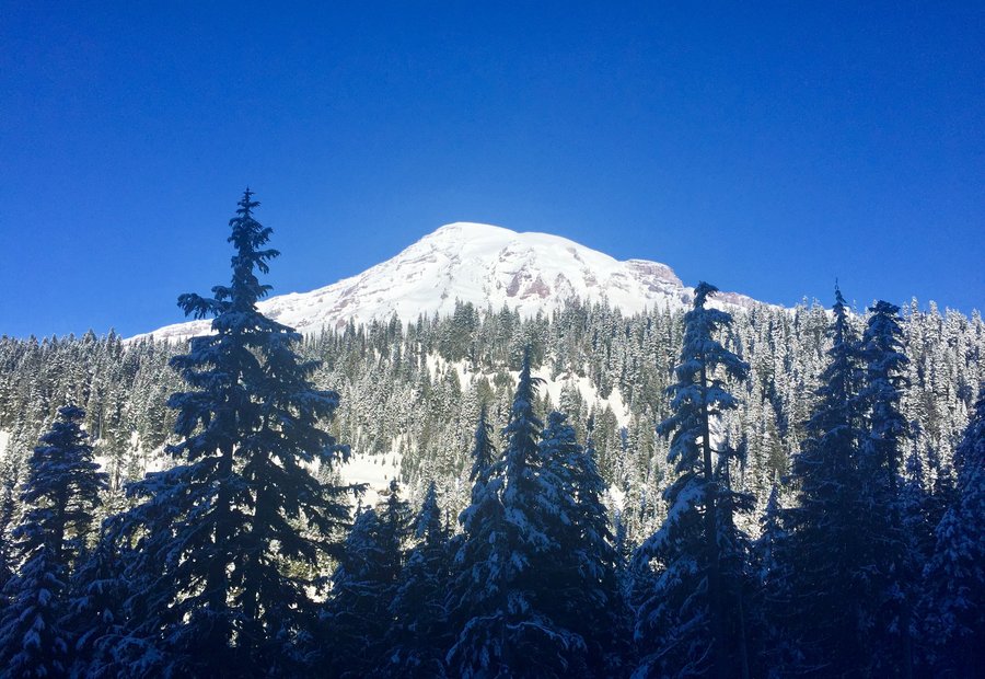
Mt. Rainier Snowshoe
7.2 miles of hiking • 1250' elevation gain •
Began hike at the Narada Falls TH. Hiked to Reflection Lake. From the lake we hiked up the closed, snow covered road to Paradise.... which was packed. From there we headed cross country for a bit and connected with a trail which took us back to the TH.
January 23, 2021


 1
1
January 17, 2021


 1
1
January 9, 2021
 1
1
Olympics--Copper Creek
5.42 miles of hiking • 2500' elevation gain •
Roaring creek and big timber... what's not to like? The trail crests the ridge at 3300'. Recent snow made the final 1000' of accent a bit of a post holing, trail breaking saga, but all in all a nice hike to start 2021.
January 1, 2021

View trips from: 2012 2013 2014 2015 2016 2017 2018 2019 2020 2022