

2013 Trips


Gales Creek Trail South From Reehers Camp
10.1 miles of hiking • 2250' elevation gain •
This was the last hike of the year for us. This is a great hike from Reehers camp south on the Gales Creek trail! We had originally intended to hike the Port of Tillamook Bay Railroad, but it is so overgrown in this area that we ended up turning around. So instead, we hiked up past Bell Camp Rd, and turned around only when we needed to get back before sunset. There were no hikers on the trail, but we saw two groups of mountain bikers. The temp. was in the mid-30's and felt great! This was a great end of the year hike! Happy New Year!

December 29, 2013

Dry Creek Trail #192 Near Trapper Creek Wilderness
8.6 miles of hiking • 750' elevation gain •
It was on the cool side but a nice holiday hike! We only saw two couples the entire day. We were trying to get to the Big Hollow trail from the Dry Creek TH, but got stopped by some water crossings that we didn't want to make on such a cold day. This is a very nice, and fairly level, forest hike with many opportunities to visit Big Hollow Creek.
December 25, 2013

Kalama Falls Trail Hike - Failed!
7.7 miles of hiking • 750' elevation gain •
The road to this hike was glazed over by the freezing fog, and at about 2500ft there was ice all over the road! We wore our micro-spikes for the entire hike as the trail was very slippery and we didn't want to risk slipping. We didn't actually know where Kalama Falls was located, so we kept taking trails that we thought led to it. However, they only led to the creek and on a cliff where a steep trail led down to the water. We know now that the falls cut-in was further down the road, but had to turn around to get back home for a family dinner. So close, but we'll have to suffer going back in the future! Happy holidays!
December 24, 2013

Larch Mt. Trail Hike
7.8 miles of hiking • 1500' elevation gain •
Went with my wife and son on this short hike. We decided to hike east on Larch Mt. Road and cut-in to the Larch Mt. trail. We headed north towards Multnomah Falls, and were glad to see Laura (Spitfire) hiking up to Larch Mt! We stopped and talked for a while, and then resumed hiking north until we bumped into her husband Rick, and stopped to talk with him a while! They're both very nice people, and I hope to see them again on the trail! It was quite a wet day, and we ended up stopping just past the rock field. Still, a great day to be on the trail! I'm looking forward to the next three days of hiking as I have a long five day weekend before going back to work. :) Happy Holiday's Everyone!
December 22, 2013

Sedum Ridge to Historic Stevenson Ridge Trail - FOUND!
11.2 miles of hiking • 1500' elevation gain •
We headed up Sedum Ridge and started from the Trout Creek Work Center parking lot. We were looking for the access to the Historic Stevenson Ridge Trail that we found on the garmin map but didn't know if it existed. The access to the trail wasn't obvious as there was brush growing where the trail started. We headed up this abandoned trail and on the way back saw a sign on a tree indicating this is the trail! This find was AMAZING!!! I would love to see this abandoned trail resurrected by the WTA or other organization. I'll write up a Portland Hiker Trip Report on this new discovery in the next day or so!
December 21, 2013

.jpg)
.jpg)
Stella Ridge Area Hike
8.2 miles of hiking • 750' elevation gain •
Very nice cloudy and foggy day in a less used location. My son went with us and wanted a somewhat shorter and easier hike, so this is a dependable hike with those qualities.
December 15, 2013
 1
1
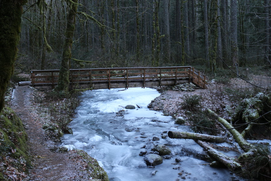
Herman Creek to Gorton Creek Trail to Deadwood Trail
10.5 miles of hiking • 2750' elevation gain •
Cloudy and coolish day but was a pleasure to hike in! Went with a friend and stopped to take pictures of Indian Point and Mt. Adams. We made it to a campsite just past a small stream/spring, which was just past the Deadwood Trail! Very enjoyable hike and am glad to have passed the 1000 mile mark for the year! We followed up this great hike with pizza!
December 14, 2013

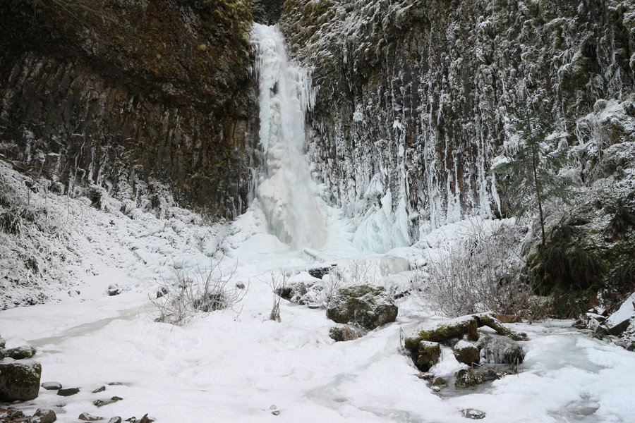
PCT to Dry Creek Falls & The Pinnacles
10.6 miles of hiking • 1500' elevation gain •
We wanted to experience al the frozen falls/creeks in the gorge and so headed out to Dry Creek Falls. Although very very cold, we were dressed appropriately and had no warmth issues! I've never seen Dry Creek Falls look quite so amazingly beautiful during the winter season, and this type of hard freeze doesn't happen very often. I highly recommend visiting in the next few days while everything is a winter wonderland! Only one couple seen the entire day!
December 8, 2013


Stella Ridge Hike
9.2 miles of hiking • 750' elevation gain •
Beautifully bitter cold day, but we were dressed for it! More mountain bikers than I would have thought, and also saw three muzzleloader hunters. Great time, but now it's time to leave for the PH Meet-n-Deet! See you there, maybe.
December 7, 2013

Herman Creek & #400 Trail Hike in Storm
10.7 miles of hiking • 1750' elevation gain •
The day started out just cloudy (and warm) and ended up being a torrential downpour! This had to be the most fun we had on a hike in such a brutally wet and windy storm. Only one group of people coming back down from the Herman Creek trail, and nobody seen after that. We came back looking like drowned rats, but were very comfortable during the entire hike. A plus for this hike is that we passed up last year's record total hiking distance, and still have one full month left till year's end!
December 1, 2013

Larch Mt. Rd towards Wahkeena & Larch Mt. Trail
10.1 miles of hiking • 1500' elevation gain •
The gate going to Larch Mt. is now closed for the season! We again hiked on NF-1520 and made it to a lower Wahkenna Trail. The trail to Devil's Rest was very crowded. The positive side is that we ran into PH Airoff again!!! We also had a few other great discussions with hikers, which just added to the fun. We then turned around and headed toward the Larch Mt. Trail by hiking down Multnomah Basin Rd. We made it to within 4/10 mile of the trail before needing to turn around, as it was getting late. Excellent hike!
November 30, 2013

Bonneville Hot Springs to Aldrich Butte Area & PCT North
8.8 miles of hiking • 2000' elevation gain •
Beautiful cool day, with no wind, in the gorge! Many hikers seen on the way out, but we lost them after coming down from Aldrich Butte after turning onto the Cedar Creek Trail. I, and many other hikers, couldn't believe our eyes when there was a large truck driving down from Aldrich Butte! That's right, a couple of complete A-holes drove to Aldrich Butte!!! There were some older hikers (79yo grandmother - Impressive!) that almost got hit by them. We didn't go too far on the Cedar Creek Trail and then headed out to hike a bit on the PCT north toward Sajawea Rock. We got out just before needing headlamps, but we expected a late hike as we arrived at the TH about noon time.
November 29, 2013

Wildwood Trail from Forest Lane to Saltzman Rd
10.9 miles of hiking • 1250' elevation gain •
Quick Thanksgiving Day hike in Forest Park as I wanted to stay close to home, and was solo. As expected, almost nobody on the trail. The weather was cool and pleasant A perfect short hike before a large dinner with the family is mighty nice!
November 28, 2013

Table Rock Wilderness at the Molalla River TH
8.4 miles of hiking • 2500' elevation gain •
What a gorgeous day, and very different from the brutal east winds we saw yesterday. We were so overdressed as the temperature at 3800ft was a balmy 59degF! Absolutely nobody was on the trail, and it was a wonderful wilderness hike! We stopped just shy of reaching the ridge after the second steep climb. It was a physically great day for me, but my wife was very tired and not up to making more distance, or altitude. Next time we do this hike we'll start at the Bull Creek TH and try to make it most of the way through the wilderness, but this probably won't be until spring.
November 24, 2013
 1
1
Beacon Rock to Almost Hardy Ridge
8.9 miles of hiking • 2500' elevation gain •
It was a beautiful sunny day, and even a bit cold at Beacon Rock State Park, but the east wind was nothing short of brutal! We arrived at the ridge via the eastern access, and the wind gusts were enough to turn us back at the first rock outcropping. I'd estimate gusts at 50+mph!!! My backpack cover was almost ripped off and my hat just shot off my head (chin strap saved it from blowing away). Plenty of ice heaving on the trail, and the view of Table Mt. revealed ice on the cliffs. Our clothing kept us warm, and resisted the wind very well, but we were in constant alert for flying branches! Only saw 3 groups of people!
November 23, 2013

Elk Creek Trail to Unknown Trail
10.1 miles of hiking • 2250' elevation gain •
Rain, rain and more rain. It never stopped raining the entire day, but it was quite an awesome hike! Only saw a few people on the first 1-2 miles out, and nobody seen after that. At the Elk Mt. cutoff, we turned right instead of the usual left turn to Elk and/or King's Mt. We ended up hiking into private logged (but replanted) land. We didn't know it was private until we got home and saw where the Tillamook State Forest boundary ended. When we got back to the car, we changed some of our clothing as we were soaked inside and out! The 2300ft+ climb drenched us inside our rain gear on the way out.
November 17, 2013

Larch Mt. Rd. to Devil's Rest
9.1 miles of hiking • 1250' elevation gain •
We were trying to make it to Larch Mt., but encountered snow on the road. We stopped at NF-1520 and took it to Devil's Rest. Only saw one person today, but it was PH Airoff! Cool day in the high 30's, but felt good! We came back to some young guys burning a huge fire across the street from our car. What the heck?
November 16, 2013
Burnt Lake Trail
8.9 miles of hiking • 1750' elevation gain •
A gorgeous day in an amazing place! Only five hikers and two dogs seen the entire day. Unfortunately, the dogs were off leash and tearing up the wilderness due to completely irresponsible owners!:( The view of snow covered Mt. Hood from the south side of Burnt Lake was breathtaking!!! We tried to make it to the top of Zigzag Ridge, but fell short on time as we got a late start. All streams and creeks were flowing nicely, but were very very easily crossable as the rocks weren't slippery! Plenty of snow (3" - 6"+) above 4100ft and we had a good time hiking in it past Burnt Lake! Much of the snow was frozen, and there was no need for Khatoula's.
November 11, 2013

Forest Park - Saltzman Rd to Wildwood Trail East
10.3 miles of hiking • 1000' elevation gain •
Beautiful hike in Forest Park! We hiked a small loop with our daughter-in-law and grand-daughter, and then set out for a longer hike on the Wildwood trail. Very few people on the trail on this perfect day in November; lucky us!
November 10, 2013

Storey Burn Loop Trail
8.8 miles of hiking • 1750' elevation gain •
This is an excellent loop trail and it was a perfect cloudy cool day for the hike! There's plenty of nice streams and a beautiful waterfall on the trail. A work party was replacing a bridge, so the main Gales Creek parking lot was full, and they were actively cutting wood. Besides this work party, only four other people were seen on the entire trail! We did see a couple of hunters leaving at the off-road bike course way up on Storey Burn road, but saw no hunters on the trail. It was a tad muddy from Hwy 6 going towards Gales Creek, but the rest of the trail was in excellent shape.
November 9, 2013

Molalla Recreation Area Hike
8.1 miles of hiking • 1000' elevation gain •
Nice cool & cloudy day which makes for nice hiking in this area! Nobody was on the trail system, and we were afforded amazing solitude! Investigated a research area on the southern end of the trail system called "Aquila Vista". We hiked up there and found most of the views were gone due to tree growth, but some glimpses indicated it was probably nice at one time?
November 3, 2013

Tanner Creek Trail Towards Dublin Lake
11.2 miles of hiking • 3250' elevation gain •
What a blustery cold day, with a thunderstorm show overhead just when we reached the Dublin Lake & Wauna Point Intersection! The thunderstorm brought 1/4" hail, and dumped quite a bit at that. Thought we saw a smidge of snow, but it was quite cold at about 3000ft. Saw a trail runner go by, with his dog, but were just off trail near a viewpoint when he passed by. Also saw a very friendly mazama member with his dog, and had a nice talk. Went on this hike with a good friend, and had a great day in the Gorge. We ended up turning around when the thunderstorm blackened the sky and the hail started falling horizontally!
November 2, 2013

Coast Hike - Segment between Yachats and Waldport
8.1 miles of hiking • 750' elevation gain •
I'm not sure how the software calculated 750ft of elevation gain, but oh well? We started from our motel at Deane's Oceanfront Resort (very nice people and clean room), and headed north toward Waldport. The weather started out blustery but had some sun break through, typical of the coast. It was fun crossing Big Creek! Almost nobody on the beach, and it was an awesome day. The sand was a bit harsh on our feet and knees though. Great way to end a fantastic long weekend!!!
October 27, 2013

Cummins Creek Wilderness Hike Cummins Ridge Trail
12.3 miles of hiking • 2500' elevation gain •
The road to the Cummins Ridge Trail is exceptional and an easy drive. At the end of the road is a parking area, and the wilderness sign is viewable from the parking lot! The first 3 miles of the trail are up the abandoned road, and it is gently graded and grass covered the whole way. At about 3 miles, you turn right, and the remainder of the hike is on a real (non-road) trail. This is a very very easy ridge hike with NO exposure. However, all the views are obstructed by some trees, but they are there. At just over 6 miles you will reach the other side of the wilderness, and there is a sign and bulleting board present. A parking area is 100ft past the wilderness sign, and it is the end of the road. It might be a nice hike to add on a short walk, on the road, to the summit of Cummins Peak? There were NO vehicles, and NO people on the trail during the entire hike!!! My only disappointment was finding a single Holly plant not far in from the trail just past the road cut-in. I'll be sending the coordinates to the forest service in hopes of them removing this non-native plant. We very highly recommend this hike just for the solitude and nice forest scenery! Unfortunately, there was no old growth in this wilderness, that we saw.
October 26, 2013

Cape Perpetua Gwynn Creek Loop Hike
7.5 miles of hiking • 2000' elevation gain •
Exceptional hike on a clear day! Plenty of old growth, but only one person seen on trail! We didn't have long to hike as we arrived late, and would have done the larger loop instead of the shorter Gwynn Creek loop. The Spouting Horn wasn't very active, but we watched a nice sunset (no colors due to fog out at sea)!
October 25, 2013

Hospital Hill - Logged!
3.2 miles of hiking • 750' elevation gain •
This was a very depressing hike! As some may know, this is a very popular biking area, but also is excellent for hiking. It is also private land that the owners have graciously allowed people to use, but doesn't want it widely publicized. We went there many times, and the hiking has always been superb. Unfortunately, a short distance on the trail revealed a huge logging operation that had just been completed. There were a dozen or more smoldering piles of ashes scattered over hundreds (?) of acres. The devastation was on a large scale, and the trail system in this area obliterated! :( We turned around after a short distance as it made us sick, and we won't go to this area again. I really can't fault the owners, as they were generous enough to allow use for recreational purposes, and this is just a warning to others that knew this area and expect to hike after a long drive from the Portland area. Oddly enough, you can't see the devastation from Bingen, and it wasn't obvious from the Hood River Bridge (unless you had been up there). I believe the logging is still going on, despite no signs, as there are equipment tracks within the remaining forest canopy that appears to be gathering up understory debris for easier logging. I'm sorry to see this area destroyed, and I suspect it will be a long time for even replanted trees to provide any canopy in this arid climate.
October 20, 2013

Wyeth Trail From Wyeth Campground
5.3 miles of hiking • 1750' elevation gain •
A great comeback from a bad morning hike. Wyeth Campground was closed, so we parked outside the gate. There were no people on the trail, and it was in exceptional shape! After crossing Harphan Creek (not much water), the trail climbs quite rapidly, and is followed by a large number of switchbacks. We didn't make it far, since we had started the hike at about 3pm, but intend on coming back here to get another great workout!
October 20, 2013

Wahtum Lake to Chinidere Mt. (twice) and Herman Creek Trail
9.3 miles of hiking • 1750' elevation gain •
What a beautiful, spectacular and clear day! We had never been to Chinidere Mt., and today was an amazing time to visit. We got up there, and immediately noticed a couple of things; we could see 5 snow covered volcanoes very clearly (St. Helens, Rainier, Adams, Hood and Jefferson!), and it was very crowded. I tried to take some movies, but there was a loud and rude group that made it unpleasant. So we left and headed down the Herman Creek Trail, but stopped short of the Mud Lake Cutoff trail. We then headed back to Chinidere, and had the summit to ourselves!!! After taking movies and pictures, again, we went back to the TH and headed home. My wife and I agreed that Chinidere Mt. is perhaps the best 360 degreee view we have ever seen in this area!
October 19, 2013

PCT at Frog Lake with Twin Lakes Loop Hike
9.1 miles of hiking • 1250' elevation gain •
Beautiful crisp day in a spectacular area, with only a few sun breaks during the day. We saw about 6 small groups of people, but had plenty of solitude. No hunters seen but one group saw some at one of the lakes. We put out a fire that was still smoking at Lower Twin Lake. There was probably no chance of a fire, since the ground was wet, but the lake was about 30ft away and the effort would have taken only 10 minutes!
October 13, 2013

Surveyor Ridge From Northern Access Point with Loop to Bald Butte
4.1 miles of hiking • 1250' elevation gain •
This was a very strange hike. There were no parking spots on Pine Mont road, so we drove around and found a parking area further on south.
What happened next was the most bizarre experience my wife and I have ever had while hiking! A man and his dog approached our car, and started talking. I can't say exactly what he said, as it was not appropriate, but the anger wasn't aimed at us, but instead at the people who stole his propane tanks and all his food! I can only describe this man as friendly, animated and filled with many stories that were came off far fetched? He proceeded to tell us he owned the 180 acres in this area, and purchased this land with the proceeds of a large California condo sale. He claimed to be the drummer for the Partridge Family, and had a degree from UCLA. He had some very strong opinions, that would be very offensive to many people, but we didn't challenge them, and he never indicated being hostile! My wife and I were a bit frightened, and weren't sure what to do and didn't want to challenge his statements. I must say that he never threatened, or asked for anything during our 45 minute talk! He showed us his housing area (looked like an abandoned RV) that had been re-decorated. He gave us a tour of his private land and showed us the old surveyor ridge trail, and some view points. At the end of our tour and discussion, he said he would watch our car to make sure it wasn't burglarized because there is much crime in the area! I ended up terminating this hike very early to avoid coming back to my vehicle being broken into, but everything was fine when we returned! However, he was there to greet us when we returned! He was very kind, and never once indicated that he wanted more than to talk! He invited us back to his land in the winter, to show us some spectacular views, and in the spring, to see the flower show. When we first met, he said he had no decent meals since mid-September, but never asked for food or money. His dog looked healthy, if not a bit overweight, and well fed! We gave him a handful of granola bars and chocolate, for which he thanked us profusely. We could tell he was lonely and anxious to talk, but we left to go to another hiking area. A completely and totally bizarre experience, and we hope this poor soul can get some help, though he seemed very happy/content where he was!
October 12, 2013

October 12, 2013

Forest Park Wildwood & Other Trails
8.6 miles of hiking • 1500' elevation gain •
I stayed close in to home since I was hiking solo, and met up with my daughter-in-law and granddaughter later in the hike. Exceptional day!
October 6, 2013

Gorge #400 TH to Tanner Cutoff Trail
13.8 miles of hiking • 2250' elevation gain •
Made it to the Tanner Cutoff Trail on this second try.. Went with a good friend and had a great time! Weather was fantastic, and started out brisk, but ended up much warmer. Only saw a couple of hikers near the TH, at the end of the hike, and saw no other people (or hunters) the entire hike.
October 5, 2013

#400 Trail toward Tanner Butte Cutoff Trail
10.1 miles of hiking • 1500' elevation gain •
Rain, rain & more rain! We headed out on the #400 trail towards the Tanner Butte Cutoff trail. I was hoping to get there, but we turned back because the intense and constant rain penetrated all our clothing and backpacks! My wife was getting chilled, and it's our agreed upon rule to turn back if either of us is uncomfortable with the situation! We bumped into a group of trail runners on the #400 trail, and they looked....challenged. On the way back we saw a lone hunter. He was carrying a rifle, and I thought it was bow or muzzleloader season. It seemed odd when he only had an orange hat, but no blaze orange vest. Something felt wrong about this person, but I wasn't about to challenge him.
September 29, 2013

Catherine Creek to Tracy Hill Hike
9.7 miles of hiking • 1750' elevation gain •
Excellent day at Catherine Creek! Not much rain, and some cloud filtered sun came out before we left. Unfortunately, there is thinning/logging going on near Tracy Hill, and the trail was jello soft muddy and not fun! Except for the Tracy Hill area, the trails were in great shape, and hikers were only seen close to the TH on the way back. We were welcomed by pelting torrential rain in the Gorge, and felt good about our choice for a hike today!!!
September 28, 2013

Silver Falls Loop & Cowlitz Divide Trails Mt. Rainier NP
8.3 miles of hiking • 1750' elevation gain •
All I can say is that Mt. Rainier NP is Awesome. We started on the East Side Trail and headed south along the Silver Falls Loop. This canyon is pure visual ecxtasy! It started raining hard, and continuously half-way through the hike, which only made the mood that much more exquisite! After 3/4ths around the loop, we headed up the Cowlitz Divide Trail, which is totally forested, but turned around due to time constraints. On the way back, my son suggested go the "Grove of the Patriarchs". The Old Growth trees here are humbling! What a way to end a great long weekend!
Corrected elevation per Topofusion.
September 22, 2013

PCT from Northern Goat Rocks to Southern William O. Douglass Wildernesses
8.2 miles of hiking • 2000' elevation gain •
Started at White Pass on the PCT. Headed south into Goat Rocks Wilderness and stopped just before Hell Lake. Met only PCT hikers here, and talked for about 25 minutes. They didn't have trail names! Then headed north into William O. Douglass Wilderness. We didn't go as far as wanted as I must have had food poisoning from very meal the night before, in Packwood WA. There were at least six PCT thru-hikers at nearby White Pass food area as their backpacks were outside! We didn't go in to meet them as I wasn't feeling well. :(
Corrected elevation per Topofusion.
September 21, 2013

East Side and Owhigh Lakes Trails Mt. Rainier NP
7.6 miles of hiking • 1750' elevation gain •
Had an excellent three day vacation at Mt. Rainier National Park with my son. This was day one, and the weather was great! Amazing number of waterfalls! Wish there was a good view of Sydney Falls, as the view through the trees indicated an amazingly large falls!
Corrected elevation per Topofusion.
September 20, 2013

Larch Mt. Mini-Loop & Franklin Ridge
10.8 miles of hiking • 2000' elevation gain •
Cool, cloudy and occasionally drizzly day - Awesome! Only saw one couple the entire day, towards the end of the day. Intense thunder at beginning of hike, but was gone after first hour. Unfortunately, no views the entire day, but the mood was ethereal/mystical!
September 15, 2013

Forest Park Wildwood Trail
9 miles of hiking • 1000' elevation gain •
Had to work today, so stayed close to home. The Wildwood Trail was in excellent condition, and only saw a dozen people on the trail all day!
September 14, 2013
 1
1
Thomas Lake TH to Blue Lake to PCT South
10.5 miles of hiking • 1500' elevation gain •
Exceptional day in Indian Heaven. A few hunters, but mostly hikers and backpackers. Met PCT thru-hiker "Rocks" and had a nice talk. We gave him plenty of snacks, that he gobbled up!
September 8, 2013

Bonneville Hot Springs to PCT and past Table Mountain
12.3 miles of hiking • 3000' elevation gain •
Superb day on the PCT. Met two nice thru-hikers, Hanna & Meg (no trail names). Also met one thru hiker that wouldn't stop and refused to give his trail name. I was kind of shocked at his dismissal of my friendly hello, and charged right past me. Oh well, I wished him well and continued on!
September 7, 2013

Cinnamon Trail - Finally Completed Mt. St. Helens Area
8.6 miles of hiking • 2000' elevation gain •
After three attempts (always in the snow), I finally finished this connection to the other side we completed. We had to put out a fire, that was still burning, in a pit that was abandoned.
September 2, 2013

Arizona Creek Trail Grand Teton NP
6.1 miles of hiking • 750' elevation gain •
Short hike as we needed to drive to Twin Falls today. This trail is NOT recommended. Most of the trail is in lowland meadows through high grasses and brush. Arizona Creek is a nice and meandering, but the water is slow moving and a great breeder of bugs. Only a couple small views of Tetons, but not good for picture taking. I picked up a Tick along the way, but it didn't get under my clothing, and we found no other ticks after a thorough inspection. I would need to investigate further before trying any of these trails again on the east side of Jackson Lake, or in Teton Wilderness.
August 31, 2013

Lewis Channel (Dogshead TH) & CDT Loop Hike Yellowstone NP
11.6 miles of hiking • 1750' elevation gain •
Exceptionally beautiful loop and very recommended! Lewis Lake and the channel are breathtaking, and it leads to the SE corner of Shoshone Lake (which is also gorgeous. We hiked back on the CDT, but met no thru-hikers. Again, we got caught in T-storms at Lewis Lake, and put on rain gear, only to shed it about an hour later.
August 30, 2013

Grinnell Creek Trail North Absaroka Wilderness
9.6 miles of hiking • 2250' elevation gain •
North Absaroka is a very rugged beautiful wilderness that is east of Yellowstone NP. I had trouble getting info and we just took our chances. Trail in excellent shape, and seems to be primarily accessed by horse, as discussed with forest service person that happened to be updating signs at TH. We felt great today, but had to turn back due to large thunderstorms and lightning. Nobody was on the trail!
August 29, 2013

Wapiti Lake Trail to Ribbon Lake & Clear Lake Loop Yellowstone NP
8.1 miles of hiking • 1500' elevation gain •
August 28, 2013

Mallard Lake & Creek Loop through Biscuit Basin Thermal Features Yellowstone NP
12.9 miles of hiking • 2500' elevation gain •
August 27, 2013

DeLacey Creek Trail to Shoshone Lake Yellowstone NP
10.4 miles of hiking • 1500' elevation gain •
This was one incredible hike. Parking lot was full, but the groups were only seen on the way out, and only before the Shoshone Lake intersection. We watched a thunderstorm show in the mountains SE of the lake, but managed to miss any downpours! We never saw anyone while on the Shoshone Lake shoreline. Plenty of meadows, but never saw any large mammals grazing, or hunting.
August 26, 2013

Cascade Lakes Trail Yellowstone NP
6 miles of hiking • 500' elevation gain •
1st day of vacation at Yellowstone NP. Got there at 4pm so could only do a short hike. Saw a coyote and two buffalo on the trail! Only night we stayed in a cabin at Canyon.
August 25, 2013

Indian Heaven Wilderness Thomas Lake TH to Junction & Blue Lake with PCT Hikers
9.2 miles of hiking • 1250' elevation gain •
Gorgeous day in Indian Heaven Wilderness. Thomas Lake TH was absolutely packed, but trail system handled the crowds well. Plenty of ripe Huckleberries, and plenty of people picking them. We started at the Thomas Lake TH, but then took a seldom used trail, near Rock Lake, to get to Junction Lake. We then met two PCT hikers, as we headed south toward Blue Lake. The PCT through hikers names were SkinnyD and Mr. Clean, and we gave them each a few treats and wished them well. We didn't see any other PCT hikers all the way to Blue Lake. We then head back to the TH from Blue Lake. We love this wilderness area, and it didn't disappoint!
August 18, 2013

Tarbell Trail to Larch Mt. Summit
11 miles of hiking • 2250' elevation gain •
Went solo today so stayed close to home. The Tarbell trail is getting less scenic as the logging has been increased on the private property outside of the National Forest. It actually looks horrible and is a shame it can't be just thinned! From some plaques, it appears Longview Fibre just about owns Larch Mt. In addition, the summit of Larch Mt. has a large fenced communication tower, which is not impressive. Part of the Tarbell trail has a detour, next to Cold Creek, due to a bridge being damaged, at least according to the Washington DNR. On a brighter note, very few people on the trail, which provided a lot of solitude. Also, a coyote darted out about 50ft in front of me, and didn't notice me, but then turned around and ran away. I also saw some very fresh (still steaming) bear scat, and started looking around and making noise. Plenty of ripe Huckleberries that tasted yummy! Also note that Dole Valley road is being actively surfaced, and I had to wait about 1/2 hour, each way, for a pilot car to take us through! What a pain. At least I connected to a previous hike, and completed this entire section of the Tarbell. I only need to complete a short 1 mile section, near Sturgeon Rock, to complete the entire Tarbell.
August 17, 2013

Herman Creek to (almost) Cedar Swamp
11.9 miles of hiking • 2000' elevation gain •
To be honest, we weren't originally headed to Cedar Swamp, but it became a goal after seeing a sign on the trail at about 4.5 miles out. We actually didn't know where Cedar Swamp was located, but later found out we were about 3/4mile short! It was a gorgeous day, and you can't go wrong with Herman Creek, on any weather kind of day for that matter. Only met about 3 pairs of backpackers (returning) on the way out, but the trail was much more crowded with day hikers on the way back. The trail is in superior condition, and all streams/creeks are easily crossable or not flowing at all. A few very nice waterfalls along the way, but with very low flow.
Corrected distance - I'm carring a garmin 60csx and 650 and found that the 650 did much better around some of the creeks. I wanted to be as accurate as possible!
August 11, 2013

PCT South From Wahtum Lake Towards Lost Lake
10.6 miles of hiking • 1000' elevation gain •
We met a couple hiking southbound on the PCT, and they are only going through Oregon & California. They had no trail names. No northbound PCT hikers seen, but we were prepared with snacks just in case. It was a semi-cloudy and cool day that turned to thunderstorms as we got back to the TH. Exceptional views of the Hatfield Wilderness near the junction with the Buck Point trail intersection. This southbound portion from Wahtum Lake is very tame (level & no exposure), but we didn't know that before the hike. As expected, Wahtum Lake was very crowded with campers, but only saw four people on the trail!
August 10, 2013

Coldwater Lake Loop Hike - Mt. St. Helens
11.9 miles of hiking • 2000' elevation gain •
This is quite an awesome hike (except for completing the loop on the road). Not many views of Mt. St. Helens, but plenty of Coldwater Lake and Mt. Margaret Backcountry. We loved the bridge and views at the inlet to Coldwater Lake. Plenty of flowers still in bloom, and many berries starting to ripen! Only saw a few people on the trail!
August 9, 2013

Cache Meadow to Indian Ridge - Roaring River Wilderness
8.8 miles of hiking • 1500' elevation gain •
Beautiful day with only 2 hikers on the trail! Only one view from old decomissioned forest road near Frazier Mountain. I was pretty much scouting out what trail conditions were and if they all existed. Plenty of trails to visit on another day. NF-4635 is a bit of a pain to drive on with all the potholes.
August 4, 2013

Stella Ridge Trail System with a Friend
11.3 miles of hiking • 1250' elevation gain •
Beautiful day on an excellent forested trail with a good friend. The trail system here is very dense with endless trails and options. Only met two bikers and no hikers the entire day! My knee felt excellent today!!!
August 3, 2013

Wright Meadows & Craggy Peak Trails - Dark Divide
9.1 miles of hiking • 1250' elevation gain •
Very nice trails in this area, with no people on trail. Trails are rutted from dirt bikes in some areas. Plenty of ripe Huckleberries everywhere! Knee didn't feel very good today.
August 2, 2013

Salmon River Trail #742 - Dry Lake Trail BRUSHED OUT!!!
9.4 miles of hiking • 1500' elevation gain •
July 28, 2013

Squaw Butte Trail #21 near NW side of Indian Heaven
10.4 miles of hiking • 1500' elevation gain •
July 27, 2013

Boundary Trail & Exploration on NE side of Mt. St. Helens
8.7 miles of hiking • 2250' elevation gain •
Actually 2 different areas of Boundary Trail on same day
Corrected wrong date! Corrected elevation - actual = 2266ft, put down 0ft initially!
July 26, 2013

Big Hollow Trail to Observation Peak - Trapper Creek Wilderness
9.2 miles of hiking • 2750' elevation gain •
Stunning view of 5 volcanoes! Almost no people!
July 21, 2013

Sandy Ridge Trail System Hike - Multiple trails
8.5 miles of hiking • 1250' elevation gain •
Nice trail but very dangerous due to heavy and fast bike traffic. Probably a good winter or wet weather hike?
July 20, 2013


Table Rock Wilderness Trail Hike Bull Creek TH
8.3 miles of hiking • 2250' elevation gain •
July 14, 2013

July 13, 2013

July 7, 2013

Pct to Racetrack Lakes via shortcut trail #171A
9 miles of hiking • 1250' elevation gain •
Includes 0.8 mile wrong TH hike towards Red Mt.
Corrected elevation - actual = 202ft extra for gated road to Red Mt., put down 0ft initially!
July 6, 2013

July 5, 2013

PCT south from Old Mackenzie Hwy towards North Sister
7.4 miles of hiking • 1250' elevation gain •
Last day of vacation. Gorgeous section of the PCT with absolutely stellar views of 5 volcanoes!!!
July 3, 2013

Waldo Lake Trail
4 miles of hiking • 750' elevation gain •
4th day of vacation. So much blowdown in burn area we had to turn around!
Corrected elevation - actual = 721ft, put down 0ft initially!
July 2, 2013

PCT North from Charlton Lake into Waldo Lake Wilderness
4.9 miles of hiking • 750' elevation gain •
4th day of vacation. 2nd hike of day. The lakes in this area are amazingly clear, with no gas motors allowed!!!
Corrected elevation - actual = 829ft, put down 0ft initially!
July 2, 2013

July 1, 2013

Elk Lake TH to PCT North near Bend Oregon
10.7 miles of hiking • 1500' elevation gain •
2nd day of vacation
June 30, 2013

Mackenzie River Trail with Clear Lake Loop
10.1 miles of hiking • 1000' elevation gain •
1st day of vacation
June 29, 2013

June 23, 2013


Old 1916 Trail #537 Hike from Little Crater Lake
10.8 miles of hiking • 1000' elevation gain •
June 16, 2013

Mt. St. Helens Hike on ski trails toward Goat Marsh
5.9 miles of hiking • 750' elevation gain •
June 15, 2013

Larch Mt. Hike
11.3 miles of hiking • 1500' elevation gain •
We couldn't believe the gate was closed, but heard it was opened tomorrow. We ended up hiking up the road anyway.
June 9, 2013


June 1, 2013


May 25, 2013


May 18, 2013


May 11, 2013

Silver Falls State Park Perimeter Trail Loop
10.3 miles of hiking • 1500' elevation gain •
May 5, 2013

Mt. St. Helens Cinnamon Trail Connect Attempt
7.2 miles of hiking • 1250' elevation gain •
May 4, 2013

Forest Park Leif Erickson Drive & Investigation
6.6 miles of hiking • 500' elevation gain •
April 28, 2013

April 27, 2013

April 21, 2013

April 20, 2013


April 13, 2013


Steigerwald Wildlife Refuge & Columbia River Dike Hike
3.6 miles of hiking • 250' elevation gain •
March 30, 2013


March 17, 2013

March 16, 2013

March 10, 2013

Columbia River Dike Hike & Steigerwald Refuge
4.8 miles of hiking • 250' elevation gain •
March 9, 2013

Historic Columbia River Hwy
3.3 miles of hiking • 250' elevation gain •
Level and paved.....Nice!
Corrected distance - actual = 3.3miles, put down 1mile initially!
March 3, 2013

Rooster Rock State Park
3.2 miles of hiking • 500' elevation gain •
Not a good move ramping up this quickly, but I did feel pretty good today!
March 2, 2013

Starvation Creek Knee Recovery 1st Hike
1 miles of hiking • 0' elevation gain •
Can you really average 0mph? It sure felt that way! We basically went to the falls on Starvation Creek and a little ways toward Viento State Park.
February 24, 2013
Hospital Hill Trail System
8 miles of hiking • 1500' elevation gain •
Last hike before knee surgery!
February 18, 2013


February 10, 2013

Mima Porter & Mckenney Trails Capitol State Forest
7.4 miles of hiking • 750' elevation gain •
February 9, 2013

February 2, 2013

January 27, 2013


January 20, 2013

January 19, 2013

January 13, 2013


Salmon River Trails
8.4 miles of hiking • 750' elevation gain •
Beautiful day on the Old Salmon River and Salmon River Trails! Plenty of snow on the ground with many icy spots. We wore Kahtoola's, which helped immensely. We were surprised that very few people were on the trail, but that worked for us!
January 6, 2013

Silver Falls Perimeter Trail & Upper North Falls
8.7 miles of hiking • 1250' elevation gain •
It was a nice cool & cloudy day with no hikers on the trail. Above 2100ft the snow was sparse but still significant in some pockets. We learned that the Perimeter Trail is now completely open! It had been closed for a while due to storm damage.
January 5, 2013

From Reehers Camp to various hiking trails
6.2 miles of hiking • 750' elevation gain •
What a beautiful winter wonderland in the Tillamook State Forest. We started at the Reehers Camp and did a bunch of different trails in the area. We went down to the Nehalem River, and then went south on the Gales Creek Trail, and then diverted onto the Step Creek Trail. Nobody on the trail system was a real plus! The snow was fairly solid, with a bit of crunch, but supported our weight nicely. A great first hike of the year!
January 1, 2013
