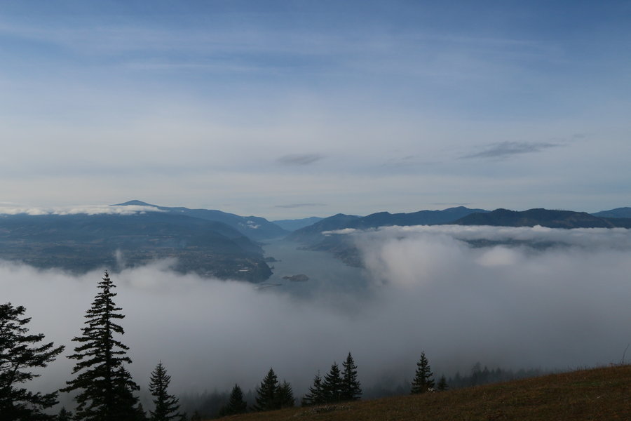
Zoom

2014 Trips Subscribe via RSS

Heart_bw 1

Klickitat Trail

10.8 miles of hiking • 500' elevation gain •

This was the last hike of my vacation and also the last for the year. The weather was fantastic with the sun coming out occasionally and with only a few sprinkles! It was a great year and we're hoping for a repeat (minus the knee and back issues) in 2015! We wish every one a happy and healthy new year in 2015!!!

Comment 3 comments

December 28, 2014

Staticmap?size=254x125&zoom=4&maptype=terrain&markers=icon:http%3a%2f%2fwenthiking.com%2fimages%2fmarkersmall.png&key=aizasydt2ewyqnn42qqnrpazuysi2dtyerccchw&center=45.712,-121
Heart_bw

Sauvie Island Warrior Rock Lighthouse

6.8 miles of hiking • 500' elevation gain •

This is the last family hike of the year and it was a rainy but pleasant day at Sauvie Island. The first half the trail was fairly muddy but we had no problems walking around the large puddle. The second half of the trail was great with no standing water or mud! We only saw one couple the entire way out to the lighthouse, but on the return hike there were quite a few more people.

Comment 0 comments

December 27, 2014

Staticmap?size=254x125&zoom=4&maptype=terrain&markers=icon:http%3a%2f%2fwenthiking.com%2fimages%2fmarkersmall.png&key=aizasydt2ewyqnn42qqnrpazuysi2dtyerccchw&center=45.8085,-122
Heart_bw

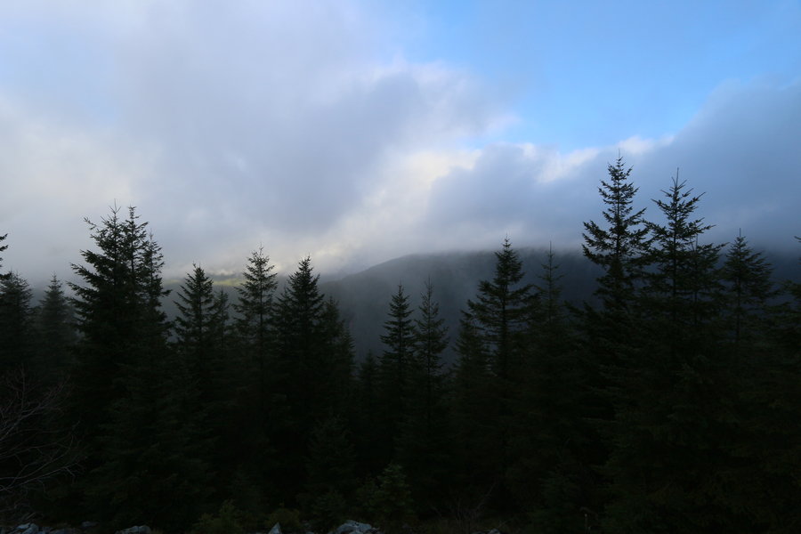
Hike near Dry Creek and Paradise Trail #124

7.5 miles of hiking • 1750' elevation gain •

The Paradise Trail is not well known or traveled, from what we can tell. Typically, this time of year, Dry Creek Rd. is gated and this becomes a road hike. Fortunately, the gate was open, and we believe this was because there is a firewood cutting area on NF-201, and also there was no snow or frost. My wife didn't feel too comfortable driving up NF-201 (although we've done it before and it's not a bad road) so we parked at the intersection with Dry Creek Road. First we walked to the Big Hollow TH that crosses Dry Creek and heads into the Trapper Creek Wilderness. I have to say that the log over Dry Creek is gnarly and slippery, so we didn't cross. Late in the summer this creek can be easily walked through. The Big Hollow trail to Observation Peak is a gem, in my opinion! At the start of our hike we were able to see that Observation Peak had snow, but I suspect it isn't very deep yet?

We next walked up NF-201 to the Paradise Trail, which is about 1.6 miles from the road intersection. The trail had a sign at one time but it appeared to be removed (not shot up). My impression is that this trail is being abandoned, but it is still easily followed despite all the debris. This trail basically climbs very very steeply for about 0.6 miles and I call this direct assault a chute. You don't need your hands, but it's an excellent workout, and our clothes were wet when we hit the ridge. About 1.5 miles from the TH is a superior view of the Dry Creek Valley and Trapper Creek Wilderness, but today there was no visibility. :( I'll attach a picture of what it looks like when clear just so you can get an idea of the amazing beauty! If you look on a map, the paradise trail goes for many miles. We have hiked much further in the summer months, but never came close to what the map is the end. If you're looking for solitude, an initial workout (the trail is level and follows abandoned forest roads further out) and at least one spectacular view then this is the trail for you! Oh, by the way, the rock outcropping area may be of interest for scramblers! Since we got out late, we had to cut the hike short due to time. :(

Comment 0 comments

December 26, 2014

Staticmap?size=254x125&zoom=4&maptype=terrain&markers=icon:http%3a%2f%2fwenthiking.com%2fimages%2fmarkersmall.png&key=aizasydt2ewyqnn42qqnrpazuysi2dtyerccchw&center=45.9209,-121
Heart_bw 1

Oxbow Regional Park Hike

5.3 miles of hiking • 750' elevation gain •

My son and I went for a short hike before family came over this evening. This is a very nice area with plenty of views of the Sandy River. The trail also had several small waterfalls located on it that were very nice! There were some people scattered throughout the park but nobody was on the trail.

Comment 2 comments

December 25, 2014

Staticmap?size=254x125&zoom=4&maptype=terrain&markers=icon:http%3a%2f%2fwenthiking.com%2fimages%2fmarkersmall.png&key=aizasydt2ewyqnn42qqnrpazuysi2dtyerccchw&center=45.4986,-122
Heart_bw

Lewis & Clark State Park Hike

7.2 miles of hiking • 750' elevation gain •

We decided to stay in WA to avoid any pre-holiday traffic after finishing our hike. We decided to try Lewis and Clark State Park as I read there is more than 10+ miles of hiking/equestrian trails. We found the trails located east of Jackson Hwy to be muddy with a large amount of blown down trees! The trails west of Jackson Hwy were in much better condition and we enjoyed them very much. Two short but very nice trails on the west side of the park were the "The Trail of the Deer" and the "Old Growth Trail". You can still expect some standing water and downed trees on the west side trail, but it's not too bad. Oh, by the way, the park is closed until spring but there is still parking on the southern boundary of the park off of Jackson Hwy.

Comment 0 comments

December 24, 2014

Staticmap?size=254x125&zoom=4&maptype=terrain&markers=icon:http%3a%2f%2fwenthiking.com%2fimages%2fmarkersmall.png&key=aizasydt2ewyqnn42qqnrpazuysi2dtyerccchw&center=46.5212,-122
Heart_bw 1

Loop Hike from Mima Falls Trail East to Campground Trail Capitol State Forest

8.3 miles of hiking • 1000' elevation gain •

It was a beautiful cloudy and drizzly day in Capitol State Forest. Since this area is about 100 miles north of Vancouver we don't go here very often. We took the Mima Falls East trail and looped around using the Campground trail back to the Mima Falls Campground. There was plenty of mud and water on the trail but it really wasn't a big deal. The mood was also fantastic! However, it should be noted that this is a multi use forest and there are plenty of clearcuts. Thankfully, all the cleared areas were replanted. :)

Comment 0 comments

December 23, 2014

Staticmap?size=254x125&zoom=4&maptype=terrain&markers=icon:http%3a%2f%2fwenthiking.com%2fimages%2fmarkersmall.png&key=aizasydt2ewyqnn42qqnrpazuysi2dtyerccchw&center=46.9022,-123
Heart_bw

Deschutes River Trail Loop Hike

8.5 miles of hiking • 500' elevation gain •

This is one our favorite trails, and for this reason we made this long drive to breakthrough the 6000 mile barrier toward our lifetime goal of 25000 miles! It was a cloudy day with some light drizzle throughout the day, and the wind was fairly tame. The Deschutes River was quite high and most of the rocks in the rapids areas were covered. We probably saw about a dozen hikers (and 3 bikers) but they were spaced out quite evenly along the upper road trail. No people were on the lower trail on our return loop.

Comment 0 comments

December 21, 2014

Staticmap?size=254x125&zoom=4&maptype=terrain&markers=icon:http%3a%2f%2fwenthiking.com%2fimages%2fmarkersmall.png&key=aizasydt2ewyqnn42qqnrpazuysi2dtyerccchw&center=45.6343,-120
Heart_bw

Lacamas Park Trail

4.9 miles of hiking • 750' elevation gain •

A nice little family hike in the pouring rain. There were a few people on the trail, but the trails were mostly devoid hikers. Plenty of water running over all the falls but the trails weren't muddy. We visited Woodburn Falls for the first time, and it was spectacular!

Comment 0 comments

December 20, 2014

Staticmap?size=254x125&zoom=4&maptype=terrain&markers=icon:http%3a%2f%2fwenthiking.com%2fimages%2fmarkersmall.png&key=aizasydt2ewyqnn42qqnrpazuysi2dtyerccchw&center=45.6039,-122
Heart_bw 1

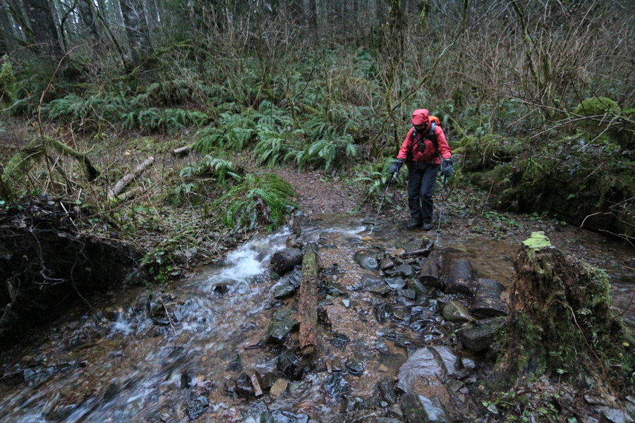
Loop Hike Starting at Still Creek Trail

10.7 miles of hiking • 750' elevation gain •

We just wanted to hike the Still Creek Trail and loop back onto the Wind Mt. trail after wrapping around along Still Creek Road, but the bridge over Still Creek was closed! We ended up walking the road and connecting to the Pioneer Bridle trail after walking much further up the road. Luckily, we met a very nice woman (and her dog) that escorted us on a shortcut to Pioneer Bridle Trail instead of going directly to Hwy 26! Nobody on the trail system today which was very nice. Only a couple of smaller downed trees across the trail in spite of the wind gusts last week.

Comment 0 comments

December 14, 2014

Staticmap?size=254x125&zoom=4&maptype=terrain&markers=icon:http%3a%2f%2fwenthiking.com%2fimages%2fmarkersmall.png&key=aizasydt2ewyqnn42qqnrpazuysi2dtyerccchw&center=45.3051,-121
Heart_bw

Hospital Hill Hike

8.4 miles of hiking • 1500' elevation gain •

Comment 0 comments

December 13, 2014

Staticmap?size=254x125&zoom=4&maptype=terrain&markers=icon:http%3a%2f%2fwenthiking.com%2fimages%2fmarkersmall.png&key=aizasydt2ewyqnn42qqnrpazuysi2dtyerccchw&center=45.7192,-121
Heart_bw 1

Gales Creek Trail to Step Creek Loop Trail

7.6 miles of hiking • 1000' elevation gain •

Beautiful day hiking on the Gales Creek Trail out of Reehers Camp. We ended up veering onto the Step Creek Trail, which wasn't completed the last time we hiked it, but it is now! The big treat for the day was that we crossed over a small stream, which runs into the Nehalem River, and there were over a dozen Salmon we observead heading up stream to spawn!!! It was quite amazing to watch, and we spent more time than expected just gazing at the fish struggling on their difficult journey! The fish were quite beat up but still fought to go upstream, resting, and then surging forward. There were some cars parked in the large parking lot, but nobody was seen on the trail.

Comment 0 comments

December 7, 2014

Staticmap?size=254x125&zoom=4&maptype=terrain&markers=icon:http%3a%2f%2fwenthiking.com%2fimages%2fmarkersmall.png&key=aizasydt2ewyqnn42qqnrpazuysi2dtyerccchw&center=45.7073,-123
Heart_bw

Lacamas Park Trail

3.9 miles of hiking • 500' elevation gain •

Went on a family hike for my son's birthday. This is actually a very nice area, and the two waterfalls we saw were phenomenal! Pothole falls reminded me of a smaller Lewis River Lower Falls! There are many short hiking trails in the park and we bumped into a gentleman that mentioned that there are many more trails which aren't documented.

Comment 0 comments

December 6, 2014

Staticmap?size=254x125&zoom=4&maptype=terrain&markers=icon:http%3a%2f%2fwenthiking.com%2fimages%2fmarkersmall.png&key=aizasydt2ewyqnn42qqnrpazuysi2dtyerccchw&center=45.6039,-122
Heart_bw

Larch Mt. Trail System Hike

8.6 miles of hiking • 1000' elevation gain •

We love this area and decided to try a hike in spite of the high winds. The last several miles on Larch Mt. Rd. were icy, but the Subaru didn't have any problems at low speeds. The temperature was parked at about 24 degrees F for the day, but we added an extra layer and had no warmth issues. We also wore our Kahtoola micro-spikes as the ground was frozen and slippery. We only saw one couple hiking the entire day, but there were about 6 cars in the gate area when we returned. It was a beautiful day and we really enjoyed the hike!

Comment 0 comments

November 30, 2014

Staticmap?size=254x125&zoom=4&maptype=terrain&markers=icon:http%3a%2f%2fwenthiking.com%2fimages%2fmarkersmall.png&key=aizasydt2ewyqnn42qqnrpazuysi2dtyerccchw&center=45.5398,-122
Heart_bw 1

Willamette Mission State Park Hike

8.5 miles of hiking • 750' elevation gain •

We've never been to this state park before and wanted to check it out. It turns out that there is a tremendous amount of flooding in this area during the heavy rain seasons, and so the main road into the park was closed to the main parking area for high water. This park is also undergoing a large amount of restoration to return it to its natural state. All that being said, it was a very pleasant hike on level terrain and with some interesting views of the Willamette River. There are numerous trails that can be explored, and we only touched a fraction of them, so we'll have to come back!

Comment 0 comments

November 29, 2014

Staticmap?size=254x125&zoom=4&maptype=terrain&markers=icon:http%3a%2f%2fwenthiking.com%2fimages%2fmarkersmall.png&key=aizasydt2ewyqnn42qqnrpazuysi2dtyerccchw&center=45.0897,-123
Heart_bw

Stella Ridge Area Hike

8.9 miles of hiking • 750' elevation gain •

It was a very wet day today and we both found out our boots have a leak in them! We only saw a pair of hunters as they returned to the TH, otherwise, there was nobody on the trail system today. There are so many trails here that we actually got disoriented and had to use the gps to get back to the return trail, and it was actually kind of fun.

Comment 0 comments

November 28, 2014

Staticmap?size=254x125&zoom=4&maptype=terrain&markers=icon:http%3a%2f%2fwenthiking.com%2fimages%2fmarkersmall.png&key=aizasydt2ewyqnn42qqnrpazuysi2dtyerccchw&center=46.2018,-123
Heart_bw

Herman Creek Area Hike

9.1 miles of hiking • 2000' elevation gain •

We enjoy going out on Holidays as the trail system is seldom crowded, wand only one person was seen on the trail. Warm day but it cooled down as we hiked out toward Camp Creek. It rained lightly for a short while, but was mostly just cloudy. This trail is always a pleasure and Herman Creek is spectacular!

Comment 0 comments

November 27, 2014

Staticmap?size=254x125&zoom=4&maptype=terrain&markers=icon:http%3a%2f%2fwenthiking.com%2fimages%2fmarkersmall.png&key=aizasydt2ewyqnn42qqnrpazuysi2dtyerccchw&center=45.6831,-121
Heart_bw

Pioneer Bridle Trail & Still Creek Side Hike

9.1 miles of hiking • 750' elevation gain •

We wanted an easy hike as our feet have been hurting. This was a very nice hike, and although the weather was nice at the start, it was raining fairly heavily and unrelenting throughout most of the hike. This is a great trail that is fairly level, and we managed to get some great views of the Zigzag River and Still Creek. The trail was basically a stream during the entire return hike. We managed to surpass our total 2013 hiking distance today, in spite of back and knee issues since August! We still have about 15 hiking days left in the year due to holidays and a week vacation, so we'll see what happens?

Comment 0 comments

November 23, 2014

Staticmap?size=254x125&zoom=4&maptype=terrain&markers=icon:http%3a%2f%2fwenthiking.com%2fimages%2fmarkersmall.png&key=aizasydt2ewyqnn42qqnrpazuysi2dtyerccchw&center=45.3199,-121
Heart_bw

Coyote Wall TH toward Catherine Creek

8.7 miles of hiking • 1500' elevation gain •

The day started out nice and then a hard rain came down for a while. Nice dusting of snow above 1000-1200ft, but typically in the shadowed areas! Beautiful day for a hike on the east side of the Cascades.

Comment 0 comments

November 22, 2014

Staticmap?size=254x125&zoom=4&maptype=terrain&markers=icon:http%3a%2f%2fwenthiking.com%2fimages%2fmarkersmall.png&key=aizasydt2ewyqnn42qqnrpazuysi2dtyerccchw&center=45.7003,-121
Heart_bw

Molalla River Recreation Area Hike

7.8 miles of hiking • 1250' elevation gain •

Finally, a nice leisurely hike with NO wind. Plenty of debris all over the forest floor. Only saw one person on horseback, but otherwise we had this beautiful place to ourselves! Temperatures in the low to mid-30's, and it felt refreshing. Had to get back home early for family, so cut the hike a bit short.

Comment 0 comments

November 16, 2014

Staticmap?size=254x125&zoom=4&maptype=terrain&markers=icon:http%3a%2f%2fwenthiking.com%2fimages%2fmarkersmall.png&key=aizasydt2ewyqnn42qqnrpazuysi2dtyerccchw&center=45.0674,-122
Heart_bw

Lacamas Heritage Trail

4.2 miles of hiking • 750' elevation gain •

Went with my wife and son for a short hike. We needed an easy level trail due to my son recovering from hip surgery about 5 months ago! He tore his labrum, which was successfully repaired, but the healing time is very looooong. This is a very nice trail that has great views of Lacamas Lake with Mt. Hood in the background. Tremendous amount of debris on the segments with trees, from wind damage. This trail also skirts next to Camas Meadows, where the homes are absolutely humongous!

Comment 0 comments

November 15, 2014

Staticmap?size=254x125&zoom=4&maptype=terrain&markers=icon:http%3a%2f%2fwenthiking.com%2fimages%2fmarkersmall.png&key=aizasydt2ewyqnn42qqnrpazuysi2dtyerccchw&center=45.6374,-122
Heart_bw

Ridgefield Wildlife Refuge

2.4 miles of hiking • 500' elevation gain •

I wanted to go hiking a bit more after the short hike this morning.

Comment 0 comments

November 15, 2014

Staticmap?size=254x125&zoom=4&maptype=terrain&markers=icon:http%3a%2f%2fwenthiking.com%2fimages%2fmarkersmall.png&key=aizasydt2ewyqnn42qqnrpazuysi2dtyerccchw&center=45.8311,-122
Heart_bw

Columbia River Dike & Steigerwald Refuge Hike

8.1 miles of hiking • 750' elevation gain •

I had the day off and we decided to stay away from possible falling trees. So we stayed close to home and went on the Columbia River Dike Hike, which was generally far enough away from the trees. We started our hike by heading east into the Gorge, so that the winds would be behind us on the way back! Heading into the wind gusts was definitely interesting, but not particularly difficult. We would have continued on the dike, but at about 3.6 miles out there is a locked fence with signs behind it that read Private Property. Very nice hike on a gusty day!

Comment 0 comments

November 11, 2014

Staticmap?size=254x125&zoom=4&maptype=terrain&markers=icon:http%3a%2f%2fwenthiking.com%2fimages%2fmarkersmall.png&key=aizasydt2ewyqnn42qqnrpazuysi2dtyerccchw&center=45.5759,-122
Heart_bw

Hardy Ridge Loop Hike

7.5 miles of hiking • 1750' elevation gain •

Hiked solo today on the Hardy Ridge Loop. Hadn't been here for years and appreciated the nice switchbacks on the east access route! It had previously been a direct assault, which is okay, but I prefer switchbacks. Only one person on the trail, but then, it was rainy and windy in the open areas. I love being out in these conditions alone, and the mode was ethereal!

Comment 0 comments

November 9, 2014

Staticmap?size=254x125&zoom=4&maptype=terrain&markers=icon:http%3a%2f%2fwenthiking.com%2fimages%2fmarkersmall.png&key=aizasydt2ewyqnn42qqnrpazuysi2dtyerccchw&center=45.6384,-122
Heart_bw

June Lake & Loowit Trail Hike

7.3 miles of hiking • 1500' elevation gain •

We had intended to go to Red Rock Pass at Mt. St. Helens, but the hunters were out in record numbers! I haven't been seeing any hunters on most hikes, but this (fairly level) area is a real hot spot. We decided to just drive on and see if there were any trails that didn't have many hunters. The June Lake TH was devoid of any trucks (all were sedans), so it appeared to be a safe hiking area? It turns out we didn't see any hunters during the entire day except when we returned and were within about 0.2 miles of the TH, and then a father and his son were heading out towards June Lake. Great day for hiking!

Comment 2 comments

November 8, 2014

Staticmap?size=254x125&zoom=4&maptype=terrain&markers=icon:http%3a%2f%2fwenthiking.com%2fimages%2fmarkersmall.png&key=aizasydt2ewyqnn42qqnrpazuysi2dtyerccchw&center=46.1361,-122
Heart_bw

Horseshoe Ridge Trail

9.4 miles of hiking • 2000' elevation gain •

Comment 0 comments

November 2, 2014

Staticmap?size=254x125&zoom=4&maptype=terrain&markers=icon:http%3a%2f%2fwenthiking.com%2fimages%2fmarkersmall.png&key=aizasydt2ewyqnn42qqnrpazuysi2dtyerccchw&center=45.3835,-121
Heart_bw

Ski Bowl to Wind Lake, Tom Dick Summit & New Trail Found

8.7 miles of hiking • 2000' elevation gain •

Comment 0 comments

November 1, 2014

Staticmap?size=254x125&zoom=4&maptype=terrain&markers=icon:http%3a%2f%2fwenthiking.com%2fimages%2fmarkersmall.png&key=aizasydt2ewyqnn42qqnrpazuysi2dtyerccchw&center=45.3024,-121
Heart_bw

Oregon Coast Hike at Driftwood State Park & Waldport

7.1 miles of hiking • 500' elevation gain •

Comment 0 comments

October 26, 2014

Staticmap?size=254x125&zoom=4&maptype=terrain&markers=icon:http%3a%2f%2fwenthiking.com%2fimages%2fmarkersmall.png&key=aizasydt2ewyqnn42qqnrpazuysi2dtyerccchw&center=44.4642,-124
Heart_bw 1

Threemile Lake & Tahkenitch Dunes Trails NEAR DEATH EXPERIENCE!!!

8.1 miles of hiking • 3250' elevation gain •

Gale force winds but beautiful area. We almost got killed after we heard the splintering of wood! We looked up and saw a 40+ foot snag falling directly at us!! We had no time to speak and both pushed backward. My wife had grabbed my backpack at the same time we moved back, and I knocked her over. The tree made a muted thump on the ground about 4 feet in front of us!!! It was actually quite terrifying, and was the closest we had come to death on any hike. We had never seen a tree fall in all our hikes, but this was a widow maker that we somehow managed to avoid. Traumatic experience we don't ever want to repeat! No more high winds for us while we hike in the forest!!!

Comment 0 comments

October 25, 2014

Staticmap?size=254x125&zoom=4&maptype=terrain&markers=icon:http%3a%2f%2fwenthiking.com%2fimages%2fmarkersmall.png&key=aizasydt2ewyqnn42qqnrpazuysi2dtyerccchw&center=43.7935,-124
Heart_bw

Whispering Spruce & Oregon Coast Trail

6.2 miles of hiking • 1250' elevation gain •

First day of Oregon Coast long weekend

Comment 0 comments

October 24, 2014

Staticmap?size=254x125&zoom=4&maptype=terrain&markers=icon:http%3a%2f%2fwenthiking.com%2fimages%2fmarkersmall.png&key=aizasydt2ewyqnn42qqnrpazuysi2dtyerccchw&center=44.2813,-124
Heart_bw

Paradise Park Trail to Zigzag Mountain Trail

12 miles of hiking • 2000' elevation gain •

Comment 0 comments

October 19, 2014

Staticmap?size=254x125&zoom=4&maptype=terrain&markers=icon:http%3a%2f%2fwenthiking.com%2fimages%2fmarkersmall.png&key=aizasydt2ewyqnn42qqnrpazuysi2dtyerccchw&center=45.3135,-121
Heart_bw

Oneonta & Bell Camp Trails

10.5 miles of hiking • 1750' elevation gain •

Comment 0 comments

October 18, 2014

Staticmap?size=254x125&zoom=4&maptype=terrain&markers=icon:http%3a%2f%2fwenthiking.com%2fimages%2fmarkersmall.png&key=aizasydt2ewyqnn42qqnrpazuysi2dtyerccchw&center=45.5279,-122
Heart_bw

PCT to Bald Mountain & Beyond

9.1 miles of hiking • 1750' elevation gain •

Comment 0 comments

October 12, 2014

Staticmap?size=254x125&zoom=4&maptype=terrain&markers=icon:http%3a%2f%2fwenthiking.com%2fimages%2fmarkersmall.png&key=aizasydt2ewyqnn42qqnrpazuysi2dtyerccchw&center=45.4271,-121
Heart_bw

Buck Creek Loop Silver Falls State Park

10.7 miles of hiking • 1250' elevation gain •

Comment 0 comments

October 11, 2014

Staticmap?size=254x125&zoom=4&maptype=terrain&markers=icon:http%3a%2f%2fwenthiking.com%2fimages%2fmarkersmall.png&key=aizasydt2ewyqnn42qqnrpazuysi2dtyerccchw&center=44.8636,-122
Heart_bw

Snipes Mt. Trail #11

9.1 miles of hiking • 1500' elevation gain •

Comment 0 comments

October 5, 2014

Staticmap?size=254x125&zoom=4&maptype=terrain&markers=icon:http%3a%2f%2fwenthiking.com%2fimages%2fmarkersmall.png&key=aizasydt2ewyqnn42qqnrpazuysi2dtyerccchw&center=46.0944,-121
Heart_bw

Cape Horn Hike

6 miles of hiking • 1250' elevation gain •

Comment 0 comments

October 4, 2014

Staticmap?size=254x125&zoom=4&maptype=terrain&markers=icon:http%3a%2f%2fwenthiking.com%2fimages%2fmarkersmall.png&key=aizasydt2ewyqnn42qqnrpazuysi2dtyerccchw&center=45.5895,-122
Heart_bw

Moulton Falls Hike with family

2.5 miles of hiking • 500' elevation gain •

Comment 0 comments

October 4, 2014

Staticmap?size=254x125&zoom=4&maptype=terrain&markers=icon:http%3a%2f%2fwenthiking.com%2fimages%2fmarkersmall.png&key=aizasydt2ewyqnn42qqnrpazuysi2dtyerccchw&center=45.8318,-122
Heart_bw 1

October 1, 2014

Staticmap?size=254x125&zoom=4&maptype=terrain&markers=icon:http%3a%2f%2fwenthiking.com%2fimages%2fmarkersmall.png&key=aizasydt2ewyqnn42qqnrpazuysi2dtyerccchw&center=46.1363,-122
Heart_bw

Veda Lake & Fir Tree Trails

10.1 miles of hiking • 1750' elevation gain •

Comment 0 comments

September 28, 2014

Staticmap?size=254x125&zoom=4&maptype=terrain&markers=icon:http%3a%2f%2fwenthiking.com%2fimages%2fmarkersmall.png&key=aizasydt2ewyqnn42qqnrpazuysi2dtyerccchw&center=45.2375,-121
Heart_bw

Newton Creek Trail & Beyond

9.4 miles of hiking • 2000' elevation gain •

Comment 0 comments

September 27, 2014

Staticmap?size=254x125&zoom=4&maptype=terrain&markers=icon:http%3a%2f%2fwenthiking.com%2fimages%2fmarkersmall.png&key=aizasydt2ewyqnn42qqnrpazuysi2dtyerccchw&center=45.3228,-121
Heart_bw

Loop Hike from Red Rock Pass to Blue Lake

9.8 miles of hiking • 1250' elevation gain •

Comment 0 comments

September 21, 2014

Staticmap?size=254x125&zoom=4&maptype=terrain&markers=icon:http%3a%2f%2fwenthiking.com%2fimages%2fmarkersmall.png&key=aizasydt2ewyqnn42qqnrpazuysi2dtyerccchw&center=46.1435,-122
Heart_bw

PCT South into Indian Heaven & Wood Lake

10.2 miles of hiking • 1750' elevation gain •

Comment 0 comments

September 20, 2014

Staticmap?size=254x125&zoom=4&maptype=terrain&markers=icon:http%3a%2f%2fwenthiking.com%2fimages%2fmarkersmall.png&key=aizasydt2ewyqnn42qqnrpazuysi2dtyerccchw&center=46.0923,-121
Heart_bw

Tilly Jane Ski Trail to Cloud Cap & Beyond

8.1 miles of hiking • 2250' elevation gain •

Comment 0 comments

September 14, 2014

Staticmap?size=254x125&zoom=4&maptype=terrain&markers=icon:http%3a%2f%2fwenthiking.com%2fimages%2fmarkersmall.png&key=aizasydt2ewyqnn42qqnrpazuysi2dtyerccchw&center=45.4167,-121
Heart_bw

Urban Hike to Council Crest with family

5.1 miles of hiking • 750' elevation gain •

Comment 0 comments

September 13, 2014

Staticmap?size=254x125&zoom=4&maptype=terrain&markers=icon:http%3a%2f%2fwenthiking.com%2fimages%2fmarkersmall.png&key=aizasydt2ewyqnn42qqnrpazuysi2dtyerccchw&center=45.4997,-122
Heart_bw

Dry Lake Trail to Fir Tree Trail to Salmon River Trail

8.2 miles of hiking • 1500' elevation gain •

Comment 0 comments

September 7, 2014

Staticmap?size=254x125&zoom=4&maptype=terrain&markers=icon:http%3a%2f%2fwenthiking.com%2fimages%2fmarkersmall.png&key=aizasydt2ewyqnn42qqnrpazuysi2dtyerccchw&center=45.2264,-121
Heart_bw 1

PCT Southbound from Timothy Lake Starting at Little Crater Lake

10.3 miles of hiking • 500' elevation gain •

Comment 0 comments

September 6, 2014

Staticmap?size=254x125&zoom=4&maptype=terrain&markers=icon:http%3a%2f%2fwenthiking.com%2fimages%2fmarkersmall.png&key=aizasydt2ewyqnn42qqnrpazuysi2dtyerccchw&center=45.1478,-121
Heart_bw

Lewis River Trail

9.2 miles of hiking • 750' elevation gain •

Comment 0 comments

September 1, 2014

Staticmap?size=254x125&zoom=4&maptype=terrain&markers=icon:http%3a%2f%2fwenthiking.com%2fimages%2fmarkersmall.png&key=aizasydt2ewyqnn42qqnrpazuysi2dtyerccchw&center=46.0622,-121
Heart_bw

Coldwater Lake Trail toward Coldwater Peak

8.1 miles of hiking • 1750' elevation gain •

Comment 0 comments

August 31, 2014

Staticmap?size=254x125&zoom=4&maptype=terrain&markers=icon:http%3a%2f%2fwenthiking.com%2fimages%2fmarkersmall.png&key=aizasydt2ewyqnn42qqnrpazuysi2dtyerccchw&center=46.2852,-122
Heart_bw

PCT Near Bunker Hill

8.2 miles of hiking • 1250' elevation gain •

Comment 0 comments

August 30, 2014

Staticmap?size=254x125&zoom=4&maptype=terrain&markers=icon:http%3a%2f%2fwenthiking.com%2fimages%2fmarkersmall.png&key=aizasydt2ewyqnn42qqnrpazuysi2dtyerccchw&center=45.8112,-121
Heart_bw

John Day Fossil Beds National Monument Blue Basin

4.5 miles of hiking • 1250' elevation gain •

Long travel day home so we kept the hike short. This is a very worthwhile loop hike with absolutely fantastic views of the Blue Basin. It was hot, but almost no people, and great for pictures!

Comment 0 comments

August 29, 2014

Staticmap?size=254x125&zoom=4&maptype=terrain&markers=icon:http%3a%2f%2fwenthiking.com%2fimages%2fmarkersmall.png&key=aizasydt2ewyqnn42qqnrpazuysi2dtyerccchw&center=44.5952,-119
Heart_bw

Strawberry Mountain Wilderness Hike

9 miles of hiking • 2000' elevation gain •

We loved this hike around Strawberry Lake and to Little Strawberry Lake. The air wasn't very clear due to smoke from fires, but the scenery was still spectacular. We had to wait for the forest service to cut a tree that blocked the road to the TH, and others had waited for 3 hours. It only took about an hour from when we arrived though.

Comment 0 comments

August 28, 2014

Staticmap?size=254x125&zoom=4&maptype=terrain&markers=icon:http%3a%2f%2fwenthiking.com%2fimages%2fmarkersmall.png&key=aizasydt2ewyqnn42qqnrpazuysi2dtyerccchw&center=44.3195,-118
Heart_bw

2014_08_27 - Canyon Mountain Trail

4.4 miles of hiking • 1000' elevation gain •

Only had time for a short hike since we drove from Joseph. Very beautiful area and I'd like to come back to explore the trails!

Comment 0 comments

August 27, 2014

Staticmap?size=254x125&zoom=4&maptype=terrain&markers=icon:http%3a%2f%2fwenthiking.com%2fimages%2fmarkersmall.png&key=aizasydt2ewyqnn42qqnrpazuysi2dtyerccchw&center=44.3651,-118
Heart_bw

Wallowa Trail Towards Ice Lake Eagle Cap Wilderness

7.7 miles of hiking • 1750' elevation gain •

Another absolutely phenomenal hike in Eagle Cap Wilderness. We initially took the Ice Lake trail but got turned around by a bear cub siting! Mama bear wasn't around, so we turned around to take the Wallowa Trail. I don't think there are any bad hikes here, so we didn't feel too bad about changing trails. The West Fork of the Wallowa River is extremely scenic and we had an awesome time!!!

Comment 0 comments

August 26, 2014

Staticmap?size=254x125&zoom=4&maptype=terrain&markers=icon:http%3a%2f%2fwenthiking.com%2fimages%2fmarkersmall.png&key=aizasydt2ewyqnn42qqnrpazuysi2dtyerccchw&center=45.2674,-117
Heart_bw

East Lostine River Hike Eagle Cap Wilderness

8.5 miles of hiking • 2000' elevation gain •

This is one awesome hike and the views are an eyegasm! I wish my stiff knee didn't hold back our hiking distance as the views just kept getting better and better. Turned around when we got to a good view of Eagle Cap. We absolutely have to come back here!!!!!

Comment 0 comments

August 25, 2014

Staticmap?size=254x125&zoom=4&maptype=terrain&markers=icon:http%3a%2f%2fwenthiking.com%2fimages%2fmarkersmall.png&key=aizasydt2ewyqnn42qqnrpazuysi2dtyerccchw&center=45.2506,-117
Heart_bw

North Fork Umatilla River Wilderness Hike

6.2 miles of hiking • 1000' elevation gain •

First day of vacation. Beautiful area with no other hikers. This trail has a huge amount of brush, but it's passable. The North Fork of the Umitilla River is quite small, but is very peaceful. The trail is often above the river and there aren't many riverside views, though.

Comment 0 comments

August 24, 2014

Staticmap?size=254x125&zoom=4&maptype=terrain&markers=icon:http%3a%2f%2fwenthiking.com%2fimages%2fmarkersmall.png&key=aizasydt2ewyqnn42qqnrpazuysi2dtyerccchw&center=45.7264,-118
Heart_bw

PCT into south Indian Heaven

6.2 miles of hiking • 750' elevation gain •

Comment 0 comments

August 23, 2014

Staticmap?size=254x125&zoom=4&maptype=terrain&markers=icon:http%3a%2f%2fwenthiking.com%2fimages%2fmarkersmall.png&key=aizasydt2ewyqnn42qqnrpazuysi2dtyerccchw&center=45.9092,-121
Heart_bw

Trillium Lake Loop Hike

4.9 miles of hiking • 500' elevation gain •

First hike where I can extend the distance, but need to keep at about 5 miles. The Dr. thinks my meniscus has been frayed, but isn't torn. Across the entire back of my knee it is sore and stiff, but I believe the meniscus has been torn in a new area from where the surgery was, but without the same type of sharp pains. I still have the issue as of today, November 6, but it's not holding me back much as long as I slow down when it gets stiff or is steep. I also need to ice my knee more often, and warm water only stiffens the knee.

This is a very beautiful area, but way too many people for me. Very little elevation gain makes the hike easier.

Comment 0 comments

August 22, 2014

Staticmap?size=254x125&zoom=4&maptype=terrain&markers=icon:http%3a%2f%2fwenthiking.com%2fimages%2fmarkersmall.png&key=aizasydt2ewyqnn42qqnrpazuysi2dtyerccchw&center=45.2862,-121
Heart_bw

PCT Hike @ Panther Creek

1.3 miles of hiking • 250' elevation gain •

Rehab hike. Walked from the road to Panther Creek and waited to pass out Oreo Cookie packs to any PCT through hikers, but only met one. It's difficult getting out on the trail and limiting the hike to such a short distance!

Comment 0 comments

August 21, 2014

Staticmap?size=254x125&zoom=4&maptype=terrain&markers=icon:http%3a%2f%2fwenthiking.com%2fimages%2fmarkersmall.png&key=aizasydt2ewyqnn42qqnrpazuysi2dtyerccchw&center=45.8176,-121
Heart_bw

Lucia Fall Hike

1.2 miles of hiking • 250' elevation gain •

Rehab Hike. This is a very beautiful area that I normally wouldn't go to because of such short trail length, but it's a great family hiking area! Sat and had a nice lunch while looking at the falls.

Comment 0 comments

August 20, 2014

Staticmap?size=254x125&zoom=4&maptype=terrain&markers=icon:http%3a%2f%2fwenthiking.com%2fimages%2fmarkersmall.png&key=aizasydt2ewyqnn42qqnrpazuysi2dtyerccchw&center=45.8405,-122
Heart_bw

Starvation Creek Falls hike

1.2 miles of hiking • 250' elevation gain •

Only allowed to walk about a mile for three days after cortisone injection to knee. Can't go longer distances until I have physical therapy at end of week.

Comment 0 comments

August 19, 2014

Staticmap?size=254x125&zoom=4&maptype=terrain&markers=icon:http%3a%2f%2fwenthiking.com%2fimages%2fmarkersmall.png&key=aizasydt2ewyqnn42qqnrpazuysi2dtyerccchw&center=45.6882,-121
Heart_bw

PCT north of Indian Heaven near Sunshine Lakes

7.1 miles of hiking • 1000' elevation gain •

The knee didn't do well today! Going to see Dr. Tomorrow.

Comment 0 comments

August 17, 2014

Staticmap?size=254x125&zoom=4&maptype=terrain&markers=icon:http%3a%2f%2fwenthiking.com%2fimages%2fmarkersmall.png&key=aizasydt2ewyqnn42qqnrpazuysi2dtyerccchw&center=46.0918,-121
Heart_bw

Boundary Trail to Badger Lake & Beyond Dark Divide

10.6 miles of hiking • 2000' elevation gain •

This was the first day of a two week vacation, and the trail in the Dark Divide was fantastic. Badger Lake is amazing and worth the rutted dirt bike trail! Unfortunately, I felt my bad knee tweak on the back inside, and I knew I had just torn my meniscus in a new location again. Cr_p, it was the first day of vacation and I ended up seeing two doctors, and had a shot of cortisone injected in it. I couldn't hike more than 1 mile per day, after taking at least two days off. Then I was told to keep the hikes down to 5 miles. We were to be going to Eagle Cap and Strawberry Mountain Wilderness, along with the John Day Fossil Beds. What a frustrating time in the next two weeks, but I manage to have some great hikes on the second of the two weeks off, as you will see when I complete adding all my hikes. I believe this year will be short 100+ miles due to this injury. Also, this meniscus injury isn't really healing, but I can still comfortably hike up to 8-12 miles, followed by ice packs. So far, a great hiking year, but fraught with new injuries. I guess it's par for the course?

Comment 0 comments

August 15, 2014

Staticmap?size=254x125&zoom=4&maptype=terrain&markers=icon:http%3a%2f%2fwenthiking.com%2fimages%2fmarkersmall.png&key=aizasydt2ewyqnn42qqnrpazuysi2dtyerccchw&center=46.2887,-121
Heart_bw

Fossil Trail Mt. St. Helens

9.4 miles of hiking • 1000' elevation gain •

Comment 0 comments

August 10, 2014

Staticmap?size=254x125&zoom=4&maptype=terrain&markers=icon:http%3a%2f%2fwenthiking.com%2fimages%2fmarkersmall.png&key=aizasydt2ewyqnn42qqnrpazuysi2dtyerccchw&center=46.143,-122
Heart_bw

PCT South from Frog Lake Sno Park

10.3 miles of hiking • 1250' elevation gain •

Comment 0 comments

August 9, 2014

Staticmap?size=254x125&zoom=4&maptype=terrain&markers=icon:http%3a%2f%2fwenthiking.com%2fimages%2fmarkersmall.png&key=aizasydt2ewyqnn42qqnrpazuysi2dtyerccchw&center=45.2286,-121
Heart_bw

Twin Lakes Loop to Palmateer Point and PCT

9.7 miles of hiking • 1250' elevation gain •

Comment 0 comments

August 3, 2014

Staticmap?size=254x125&zoom=4&maptype=terrain&markers=icon:http%3a%2f%2fwenthiking.com%2fimages%2fmarkersmall.png&key=aizasydt2ewyqnn42qqnrpazuysi2dtyerccchw&center=45.2286,-121
Heart_bw

PCT near Steamboat Lake past Trout Lake Creek

9.6 miles of hiking • 1500' elevation gain •

Comment 0 comments

August 2, 2014

Staticmap?size=254x125&zoom=4&maptype=terrain&markers=icon:http%3a%2f%2fwenthiking.com%2fimages%2fmarkersmall.png&key=aizasydt2ewyqnn42qqnrpazuysi2dtyerccchw&center=46.124,-121
Heart_bw

Bonneviille Hot Springs to Cave Falls

9.3 miles of hiking • 1750' elevation gain •

Comment 0 comments

July 27, 2014

Staticmap?size=254x125&zoom=4&maptype=terrain&markers=icon:http%3a%2f%2fwenthiking.com%2fimages%2fmarkersmall.png&key=aizasydt2ewyqnn42qqnrpazuysi2dtyerccchw&center=45.6552,-121
Heart_bw

Cultus Creek TH to PCT

10.4 miles of hiking • 1000' elevation gain •

Comment 0 comments

July 26, 2014

Staticmap?size=254x125&zoom=4&maptype=terrain&markers=icon:http%3a%2f%2fwenthiking.com%2fimages%2fmarkersmall.png&key=aizasydt2ewyqnn42qqnrpazuysi2dtyerccchw&center=46.0485,-121
Heart_bw

Bagby Hot Springs into Bull of the Woods Wilderness

8.1 miles of hiking • 2250' elevation gain •

Comment 0 comments

July 20, 2014

Staticmap?size=254x125&zoom=4&maptype=terrain&markers=icon:http%3a%2f%2fwenthiking.com%2fimages%2fmarkersmall.png&key=aizasydt2ewyqnn42qqnrpazuysi2dtyerccchw&center=44.9544,-122
Heart_bw

Bonneville Hot Springs to Greenleaf Falls

9.6 miles of hiking • 1000' elevation gain •

Comment 0 comments

July 19, 2014

Staticmap?size=254x125&zoom=4&maptype=terrain&markers=icon:http%3a%2f%2fwenthiking.com%2fimages%2fmarkersmall.png&key=aizasydt2ewyqnn42qqnrpazuysi2dtyerccchw&center=45.6553,-121
Heart_bw

North Fork Skokomish River Trail

10.6 miles of hiking • 1000' elevation gain •

Comment 0 comments

July 13, 2014

Staticmap?size=254x125&zoom=4&maptype=terrain&markers=icon:http%3a%2f%2fwenthiking.com%2fimages%2fmarkersmall.png&key=aizasydt2ewyqnn42qqnrpazuysi2dtyerccchw&center=47.5141,-123
Heart_bw

PCT South from Olallie Lake

10.1 miles of hiking • 1250' elevation gain •

Comment 0 comments

July 12, 2014

Staticmap?size=254x125&zoom=4&maptype=terrain&markers=icon:http%3a%2f%2fwenthiking.com%2fimages%2fmarkersmall.png&key=aizasydt2ewyqnn42qqnrpazuysi2dtyerccchw&center=44.8157,-121
Heart_bw

Surveyor Ridge Trail Hike

10.2 miles of hiking • 1750' elevation gain •

Comment 0 comments

July 6, 2014

Staticmap?size=254x125&zoom=4&maptype=terrain&markers=icon:http%3a%2f%2fwenthiking.com%2fimages%2fmarkersmall.png&key=aizasydt2ewyqnn42qqnrpazuysi2dtyerccchw&center=45.469,-121
Heart_bw

PCT South Towards Mt. Ashland

5.1 miles of hiking • 1250' elevation gain •

Comment 0 comments

July 4, 2014

Staticmap?size=254x125&zoom=4&maptype=terrain&markers=icon:http%3a%2f%2fwenthiking.com%2fimages%2fmarkersmall.png&key=aizasydt2ewyqnn42qqnrpazuysi2dtyerccchw&center=42.0659,-122
Heart_bw

Past Pilot Rock Soda Mountain Wilderness

10.4 miles of hiking • 2250' elevation gain •

Comment 0 comments

July 3, 2014

Staticmap?size=254x125&zoom=4&maptype=terrain&markers=icon:http%3a%2f%2fwenthiking.com%2fimages%2fmarkersmall.png&key=aizasydt2ewyqnn42qqnrpazuysi2dtyerccchw&center=42.0607,-122
Heart_bw

PCT Hike at Crater Lake National Park

10.7 miles of hiking • 1750' elevation gain •

Comment 0 comments

July 2, 2014

Staticmap?size=254x125&zoom=4&maptype=terrain&markers=icon:http%3a%2f%2fwenthiking.com%2fimages%2fmarkersmall.png&key=aizasydt2ewyqnn42qqnrpazuysi2dtyerccchw&center=42.8711,-122
Heart_bw

Three Sisters Wilderness Mirror Lake Trail

10.1 miles of hiking • 1750' elevation gain •

Comment 0 comments

July 1, 2014

Staticmap?size=254x125&zoom=4&maptype=terrain&markers=icon:http%3a%2f%2fwenthiking.com%2fimages%2fmarkersmall.png&key=aizasydt2ewyqnn42qqnrpazuysi2dtyerccchw&center=44.0166,-121
Heart_bw

PCT South from ElK Lake Three Sisters Wilderness

11.5 miles of hiking • 1750' elevation gain •

Comment 0 comments

June 30, 2014

Staticmap?size=254x125&zoom=4&maptype=terrain&markers=icon:http%3a%2f%2fwenthiking.com%2fimages%2fmarkersmall.png&key=aizasydt2ewyqnn42qqnrpazuysi2dtyerccchw&center=43.9826,-121
Heart_bw

Waldo Lake Trail & Wilderness Hike

10.9 miles of hiking • 2250' elevation gain •

Comment 0 comments

June 29, 2014

Staticmap?size=254x125&zoom=4&maptype=terrain&markers=icon:http%3a%2f%2fwenthiking.com%2fimages%2fmarkersmall.png&key=aizasydt2ewyqnn42qqnrpazuysi2dtyerccchw&center=43.6926,-122
Heart_bw

Square & Booth Lakes Mt. Jefferson Wilderness

9 miles of hiking • 1750' elevation gain •

Start of summer vacation!

Comment 0 comments

June 28, 2014

Staticmap?size=254x125&zoom=4&maptype=terrain&markers=icon:http%3a%2f%2fwenthiking.com%2fimages%2fmarkersmall.png&key=aizasydt2ewyqnn42qqnrpazuysi2dtyerccchw&center=44.4252,-121
Heart_bw

Bonneville Hot Springs Area Hike

7 miles of hiking • 1750' elevation gain •

Comment 0 comments

June 22, 2014

Staticmap?size=254x125&zoom=4&maptype=terrain&markers=icon:http%3a%2f%2fwenthiking.com%2fimages%2fmarkersmall.png&key=aizasydt2ewyqnn42qqnrpazuysi2dtyerccchw&center=45.6553,-121
Heart_bw

Wilson River Trail from King's Mt. TH

6.1 miles of hiking • 1500' elevation gain •

Comment 0 comments

June 21, 2014

Staticmap?size=254x125&zoom=4&maptype=terrain&markers=icon:http%3a%2f%2fwenthiking.com%2fimages%2fmarkersmall.png&key=aizasydt2ewyqnn42qqnrpazuysi2dtyerccchw&center=45.5971,-123
Heart_bw

Ridgfield Wildlife Refuge with family on Fathers Day

2.6 miles of hiking • 500' elevation gain •

Comment 0 comments

June 15, 2014

Staticmap?size=254x125&zoom=4&maptype=terrain&markers=icon:http%3a%2f%2fwenthiking.com%2fimages%2fmarkersmall.png&key=aizasydt2ewyqnn42qqnrpazuysi2dtyerccchw&center=45.8313,-122
Heart_bw

Stella Ridge Hike

8.3 miles of hiking • 1250' elevation gain •

Comment 0 comments

June 15, 2014

Staticmap?size=254x125&zoom=4&maptype=terrain&markers=icon:http%3a%2f%2fwenthiking.com%2fimages%2fmarkersmall.png&key=aizasydt2ewyqnn42qqnrpazuysi2dtyerccchw&center=46.2039,-123
Heart_bw

Kalama Horse Camp towards Goat Marsh

7.3 miles of hiking • 750' elevation gain •

Comment 0 comments

June 14, 2014

Staticmap?size=254x125&zoom=4&maptype=terrain&markers=icon:http%3a%2f%2fwenthiking.com%2fimages%2fmarkersmall.png&key=aizasydt2ewyqnn42qqnrpazuysi2dtyerccchw&center=46.1427,-122
Heart_bw

PCT into Warm Springs Reservation

11.3 miles of hiking • 1000' elevation gain •

Comment 0 comments

June 8, 2014

Staticmap?size=254x125&zoom=4&maptype=terrain&markers=icon:http%3a%2f%2fwenthiking.com%2fimages%2fmarkersmall.png&key=aizasydt2ewyqnn42qqnrpazuysi2dtyerccchw&center=45.1017,-121
Heart_bw

Nick Eaton Way to Ridge to Gorton Creek Loop

10.5 miles of hiking • 3750' elevation gain •

Comment 0 comments

June 7, 2014

Staticmap?size=254x125&zoom=4&maptype=terrain&markers=icon:http%3a%2f%2fwenthiking.com%2fimages%2fmarkersmall.png&key=aizasydt2ewyqnn42qqnrpazuysi2dtyerccchw&center=45.6831,-121
Heart_bw

PCT South Toward Huckleberry Mt.

10.7 miles of hiking • 1000' elevation gain •

Comment 0 comments

June 1, 2014

Staticmap?size=254x125&zoom=4&maptype=terrain&markers=icon:http%3a%2f%2fwenthiking.com%2fimages%2fmarkersmall.png&key=aizasydt2ewyqnn42qqnrpazuysi2dtyerccchw&center=45.9093,-121
Heart_bw

Trapper Creek Wilderness Soda Peaks Lake Hike

11.3 miles of hiking • 3000' elevation gain •

Comment 0 comments

May 31, 2014

Staticmap?size=254x125&zoom=4&maptype=terrain&markers=icon:http%3a%2f%2fwenthiking.com%2fimages%2fmarkersmall.png&key=aizasydt2ewyqnn42qqnrpazuysi2dtyerccchw&center=45.8817,-121
Heart_bw

Little Crater Lake to Meditation Point & Beyond

10.6 miles of hiking • 750' elevation gain •

Comment 0 comments

May 26, 2014

Staticmap?size=254x125&zoom=4&maptype=terrain&markers=icon:http%3a%2f%2fwenthiking.com%2fimages%2fmarkersmall.png&key=aizasydt2ewyqnn42qqnrpazuysi2dtyerccchw&center=45.1479,-121
Heart_bw

Kalama Falls - Almost!

10 miles of hiking • 750' elevation gain •

Comment 0 comments

May 25, 2014

Staticmap?size=254x125&zoom=4&maptype=terrain&markers=icon:http%3a%2f%2fwenthiking.com%2fimages%2fmarkersmall.png&key=aizasydt2ewyqnn42qqnrpazuysi2dtyerccchw&center=46.1428,-122
Heart_bw

McIntyre Ridge to Douglass Trail West & Connect

12 miles of hiking • 2500' elevation gain •

Comment 0 comments

May 24, 2014

Staticmap?size=254x125&zoom=4&maptype=terrain&markers=icon:http%3a%2f%2fwenthiking.com%2fimages%2fmarkersmall.png&key=aizasydt2ewyqnn42qqnrpazuysi2dtyerccchw&center=45.3332,-122
Heart_bw

Frog & Lower Twin Lake with PCT

12.3 miles of hiking • 2500' elevation gain •

Comment 0 comments

May 18, 2014

Staticmap?size=254x125&zoom=4&maptype=terrain&markers=icon:http%3a%2f%2fwenthiking.com%2fimages%2fmarkersmall.png&key=aizasydt2ewyqnn42qqnrpazuysi2dtyerccchw&center=45.2286,-121
Heart_bw

Bonneville Hot Springs to Table Mt. Not!

11.9 miles of hiking • 3000' elevation gain •

I tweaked my sciatic nerve and SI joint very badly while on Table Mt. This was the beginning of a very long PT and a couple of Dr.'s, which didn't seem to be working, but the issue just went away after about 4 months. I'm very thankful this went away as it was very painful!!! For whatever reason, it seemed to work out during a hike, but came back with a vengeance when not warmed up. However, uneven ground was a killer!

Comment 0 comments

May 17, 2014

Staticmap?size=254x125&zoom=4&maptype=terrain&markers=icon:http%3a%2f%2fwenthiking.com%2fimages%2fmarkersmall.png&key=aizasydt2ewyqnn42qqnrpazuysi2dtyerccchw&center=45.6553,-121
Heart_bw

Larch Mt. Area Loop Hike

9.1 miles of hiking • 1500' elevation gain •

Comment 0 comments

May 11, 2014

Staticmap?size=254x125&zoom=4&maptype=terrain&markers=icon:http%3a%2f%2fwenthiking.com%2fimages%2fmarkersmall.png&key=aizasydt2ewyqnn42qqnrpazuysi2dtyerccchw&center=45.5398,-122
Heart_bw

PCT to Past Grassy Knoll Trail

10.3 miles of hiking • 2000' elevation gain •

Comment 0 comments

May 10, 2014

Staticmap?size=254x125&zoom=4&maptype=terrain&markers=icon:http%3a%2f%2fwenthiking.com%2fimages%2fmarkersmall.png&key=aizasydt2ewyqnn42qqnrpazuysi2dtyerccchw&center=45.8281,-121
Heart_bw

Tarbell Trail to Hidden Falls & Connection

11.5 miles of hiking • 2500' elevation gain •

Took an abandoned road to the Tarbell Trail after getting lost on road for a while!

Comment 0 comments

May 4, 2014

Staticmap?size=254x125&zoom=4&maptype=terrain&markers=icon:http%3a%2f%2fwenthiking.com%2fimages%2fmarkersmall.png&key=aizasydt2ewyqnn42qqnrpazuysi2dtyerccchw&center=45.7702,-122
Heart_bw

Buck Creek Trail to Nestor Peak & Beyond

11 miles of hiking • 3000' elevation gain •

Comment 0 comments

May 3, 2014

Staticmap?size=254x125&zoom=4&maptype=terrain&markers=icon:http%3a%2f%2fwenthiking.com%2fimages%2fmarkersmall.png&key=aizasydt2ewyqnn42qqnrpazuysi2dtyerccchw&center=45.7964,-121
Heart_bw

Reehers Camp to Step Creek to Gales Creek to TripleC Loop Hike

11 miles of hiking • 1750' elevation gain •

Comment 0 comments

April 27, 2014

Staticmap?size=254x125&zoom=4&maptype=terrain&markers=icon:http%3a%2f%2fwenthiking.com%2fimages%2fmarkersmall.png&key=aizasydt2ewyqnn42qqnrpazuysi2dtyerccchw&center=45.7076,-123
Heart_bw

Buck Creek - Penny Ridge past Monte Carlo Summit

10.3 miles of hiking • 2750' elevation gain •

Comment 0 comments

April 26, 2014

Staticmap?size=254x125&zoom=4&maptype=terrain&markers=icon:http%3a%2f%2fwenthiking.com%2fimages%2fmarkersmall.png&key=aizasydt2ewyqnn42qqnrpazuysi2dtyerccchw&center=45.8338,-121
Heart_bw

Falls Creek Trail to Overlook

10.1 miles of hiking • 750' elevation gain •

Comment 0 comments

April 20, 2014

Staticmap?size=254x125&zoom=4&maptype=terrain&markers=icon:http%3a%2f%2fwenthiking.com%2fimages%2fmarkersmall.png&key=aizasydt2ewyqnn42qqnrpazuysi2dtyerccchw&center=45.9338,-121
Heart_bw

Murphy Grade & Bells Mt. Trail

10.3 miles of hiking • 1250' elevation gain •

Comment 0 comments

April 19, 2014

Staticmap?size=254x125&zoom=4&maptype=terrain&markers=icon:http%3a%2f%2fwenthiking.com%2fimages%2fmarkersmall.png&key=aizasydt2ewyqnn42qqnrpazuysi2dtyerccchw&center=45.8378,-122
Heart_bw

PCT North From Panther Creek

10.7 miles of hiking • 1750' elevation gain •

Comment 0 comments

April 13, 2014

Staticmap?size=254x125&zoom=4&maptype=terrain&markers=icon:http%3a%2f%2fwenthiking.com%2fimages%2fmarkersmall.png&key=aizasydt2ewyqnn42qqnrpazuysi2dtyerccchw&center=45.8177,-121
Heart_bw

Riverside Trail Clackamas River

10.3 miles of hiking • 1500' elevation gain •

Comment 0 comments

April 12, 2014

Staticmap?size=254x125&zoom=4&maptype=terrain&markers=icon:http%3a%2f%2fwenthiking.com%2fimages%2fmarkersmall.png&key=aizasydt2ewyqnn42qqnrpazuysi2dtyerccchw&center=45.0794,-122
Heart_bw

Siouxon Creek Hike

9.8 miles of hiking • 1500' elevation gain •

Comment 0 comments

April 11, 2014

Staticmap?size=254x125&zoom=4&maptype=terrain&markers=icon:http%3a%2f%2fwenthiking.com%2fimages%2fmarkersmall.png&key=aizasydt2ewyqnn42qqnrpazuysi2dtyerccchw&center=45.9463,-122
Heart_bw

Beacon Rock Hardy Ridge Hike

10.7 miles of hiking • 2250' elevation gain •

Comment 0 comments

April 10, 2014

Staticmap?size=254x125&zoom=4&maptype=terrain&markers=icon:http%3a%2f%2fwenthiking.com%2fimages%2fmarkersmall.png&key=aizasydt2ewyqnn42qqnrpazuysi2dtyerccchw&center=45.6385,-122
Heart_bw

Forest Park Springville Road to Leif Erikson Road

9 miles of hiking • 750' elevation gain •

Comment 0 comments

April 6, 2014

Staticmap?size=254x125&zoom=4&maptype=terrain&markers=icon:http%3a%2f%2fwenthiking.com%2fimages%2fmarkersmall.png&key=aizasydt2ewyqnn42qqnrpazuysi2dtyerccchw&center=45.5743,-122
Heart_bw

PCT to Stevenson Ridge Trail

12.2 miles of hiking • 2250' elevation gain •

Comment 0 comments

April 5, 2014

Staticmap?size=254x125&zoom=4&maptype=terrain&markers=icon:http%3a%2f%2fwenthiking.com%2fimages%2fmarkersmall.png&key=aizasydt2ewyqnn42qqnrpazuysi2dtyerccchw&center=45.8113,-121
Heart_bw

Mollala River Trail System Hike

8.8 miles of hiking • 1250' elevation gain •

Comment 0 comments

March 30, 2014

Staticmap?size=254x125&zoom=4&maptype=terrain&markers=icon:http%3a%2f%2fwenthiking.com%2fimages%2fmarkersmall.png&key=aizasydt2ewyqnn42qqnrpazuysi2dtyerccchw&center=45.0163,-122
Heart_bw

Swale Canyon Hike

13 miles of hiking • 750' elevation gain •

Comment 0 comments

March 29, 2014

Staticmap?size=254x125&zoom=4&maptype=terrain&markers=icon:http%3a%2f%2fwenthiking.com%2fimages%2fmarkersmall.png&key=aizasydt2ewyqnn42qqnrpazuysi2dtyerccchw&center=45.7228,-121
Heart_bw

Deschutes River Trail to Box Car

12.3 miles of hiking • 500' elevation gain •

Comment 0 comments

March 23, 2014

Staticmap?size=254x125&zoom=4&maptype=terrain&markers=icon:http%3a%2f%2fwenthiking.com%2fimages%2fmarkersmall.png&key=aizasydt2ewyqnn42qqnrpazuysi2dtyerccchw&center=45.6342,-120
Heart_bw

Forest Park Wildwood Trail

6.8 miles of hiking • 1000' elevation gain •

Comment 0 comments

March 22, 2014

Staticmap?size=254x125&zoom=4&maptype=terrain&markers=icon:http%3a%2f%2fwenthiking.com%2fimages%2fmarkersmall.png&key=aizasydt2ewyqnn42qqnrpazuysi2dtyerccchw&center=45.5265,-122
Heart_bw

Millersylvania State Park Hike

10.3 miles of hiking • 500' elevation gain •

Comment 0 comments

March 16, 2014

Staticmap?size=254x125&zoom=4&maptype=terrain&markers=icon:http%3a%2f%2fwenthiking.com%2fimages%2fmarkersmall.png&key=aizasydt2ewyqnn42qqnrpazuysi2dtyerccchw&center=46.9097,-122
Heart_bw

Monte Carlo Trail to Buck Creek Trail & Beyond

8.4 miles of hiking • 2250' elevation gain •

Comment 0 comments

March 15, 2014

Staticmap?size=254x125&zoom=4&maptype=terrain&markers=icon:http%3a%2f%2fwenthiking.com%2fimages%2fmarkersmall.png&key=aizasydt2ewyqnn42qqnrpazuysi2dtyerccchw&center=45.8697,-121
Heart_bw

Milo McIver State Park Hike

9.4 miles of hiking • 1000' elevation gain •

Comment 0 comments

March 9, 2014

Staticmap?size=254x125&zoom=4&maptype=terrain&markers=icon:http%3a%2f%2fwenthiking.com%2fimages%2fmarkersmall.png&key=aizasydt2ewyqnn42qqnrpazuysi2dtyerccchw&center=45.3063,-122
Heart_bw

Hospital Hill Hike

8.9 miles of hiking • 1750' elevation gain •

Comment 0 comments

March 8, 2014

Staticmap?size=254x125&zoom=4&maptype=terrain&markers=icon:http%3a%2f%2fwenthiking.com%2fimages%2fmarkersmall.png&key=aizasydt2ewyqnn42qqnrpazuysi2dtyerccchw&center=45.7038,-121
Heart_bw

Silver Falls Buck Creek Loop and Beyond

10.5 miles of hiking • 1500' elevation gain •

Comment 0 comments

March 2, 2014

Staticmap?size=254x125&zoom=4&maptype=terrain&markers=icon:http%3a%2f%2fwenthiking.com%2fimages%2fmarkersmall.png&key=aizasydt2ewyqnn42qqnrpazuysi2dtyerccchw&center=44.8636,-122
Heart_bw

Bells Mt. Trail

12.5 miles of hiking • 2750' elevation gain •

Comment 0 comments

March 1, 2014

Staticmap?size=254x125&zoom=4&maptype=terrain&markers=icon:http%3a%2f%2fwenthiking.com%2fimages%2fmarkersmall.png&key=aizasydt2ewyqnn42qqnrpazuysi2dtyerccchw&center=45.8318,-122
Heart_bw

Klickitat River Trail from Hwy 14 Parking Area

11 miles of hiking • 250' elevation gain •

Comment 0 comments

February 23, 2014

Staticmap?size=254x125&zoom=4&maptype=terrain&markers=icon:http%3a%2f%2fwenthiking.com%2fimages%2fmarkersmall.png&key=aizasydt2ewyqnn42qqnrpazuysi2dtyerccchw&center=45.6962,-121
Heart_bw

Wilson River Trail from Keenig Creek

10.3 miles of hiking • 1750' elevation gain •

Comment 0 comments

February 22, 2014

Staticmap?size=254x125&zoom=4&maptype=terrain&markers=icon:http%3a%2f%2fwenthiking.com%2fimages%2fmarkersmall.png&key=aizasydt2ewyqnn42qqnrpazuysi2dtyerccchw&center=45.5434,-123
Heart_bw

Catherine Creek Area Hikes

8.1 miles of hiking • 2000' elevation gain •

Comment 0 comments

February 17, 2014

Staticmap?size=254x125&zoom=4&maptype=terrain&markers=icon:http%3a%2f%2fwenthiking.com%2fimages%2fmarkersmall.png&key=aizasydt2ewyqnn42qqnrpazuysi2dtyerccchw&center=45.7108,-121
Heart_bw

Stella Ridge Hike

10.7 miles of hiking • 1250' elevation gain •

Comment 0 comments

February 16, 2014

Staticmap?size=254x125&zoom=4&maptype=terrain&markers=icon:http%3a%2f%2fwenthiking.com%2fimages%2fmarkersmall.png&key=aizasydt2ewyqnn42qqnrpazuysi2dtyerccchw&center=46.2215,-123
Heart_bw

Gnat Creek Trail Hike

9.6 miles of hiking • 1500' elevation gain •

Comment 0 comments

February 15, 2014

Staticmap?size=254x125&zoom=4&maptype=terrain&markers=icon:http%3a%2f%2fwenthiking.com%2fimages%2fmarkersmall.png&key=aizasydt2ewyqnn42qqnrpazuysi2dtyerccchw&center=46.1766,-123
Heart_bw

From Home and through Salmon Creek Greenway during Winter Storm

9.2 miles of hiking • 500' elevation gain •

Comment 0 comments

February 8, 2014

Staticmap?size=254x125&zoom=4&maptype=terrain&markers=icon:http%3a%2f%2fwenthiking.com%2fimages%2fmarkersmall.png&key=aizasydt2ewyqnn42qqnrpazuysi2dtyerccchw&center=45.7059,-122
Heart_bw

Molalla River Recreation Area Hike

10.1 miles of hiking • 1750' elevation gain •

Comment 0 comments

February 2, 2014

Staticmap?size=254x125&zoom=4&maptype=terrain&markers=icon:http%3a%2f%2fwenthiking.com%2fimages%2fmarkersmall.png&key=aizasydt2ewyqnn42qqnrpazuysi2dtyerccchw&center=45.0595,-122
Heart_bw

Tanner Butte Trail towards Dublin Lake

13.2 miles of hiking • 3500' elevation gain •

Comment 0 comments

February 1, 2014

Staticmap?size=254x125&zoom=4&maptype=terrain&markers=icon:http%3a%2f%2fwenthiking.com%2fimages%2fmarkersmall.png&key=aizasydt2ewyqnn42qqnrpazuysi2dtyerccchw&center=45.6315,-121
Heart_bw

Capitol State Forest Hike

9.6 miles of hiking • 1500' elevation gain •

A gorgeous day with NO people on the trail! There were a few areas that were quite muddy and like walking on jello. One area had a stellar view of Mt. Rainier, and we could also see the tip of Mt. Adams! We started on the Waddle Basin Trail and ended up at the Divide Trail. This forest has a huge trail system, but it's shared with bikes and ATV's. Fortunately, no motorized off-road vehicles allowed on the trails until April 30th! This is a multi-use forest like the Tillamook State Forest area, but much less crowded. Quite a long drive, located near Olympia, but we live in Vancouver and can reach the SW area in about 1-1/2 hours.

Comment 0 comments

January 26, 2014

Staticmap?size=254x125&zoom=4&maptype=terrain&markers=icon:http%3a%2f%2fwenthiking.com%2fimages%2fmarkersmall.png&key=aizasydt2ewyqnn42qqnrpazuysi2dtyerccchw&center=46.9453,-123
Heart_bw

Buck Creek to Perimeter Trail Loop Silver Falls State Park

11.3 miles of hiking • 1500' elevation gain •

Felt more like summer than winter! Only saw one group of people during the entire hike! Plenty of old growth, and the trail was plenty wet despite the lack of rain. We took the Buck Creek Trail out to the Perimeter Trail and then closed the loop on the Rackett Ridge Trail for the return. We also explored a couple other roads that looked of interest. Great day in a beautiful forest with plenty of solitude!

Comment 0 comments

January 25, 2014

Staticmap?size=254x125&zoom=4&maptype=terrain&markers=icon:http%3a%2f%2fwenthiking.com%2fimages%2fmarkersmall.png&key=aizasydt2ewyqnn42qqnrpazuysi2dtyerccchw&center=44.8638,-122
Heart_bw

Coyote Wall Area Exploration

9.4 miles of hiking • 1750' elevation gain •

Well, I heard it was sunny in the Portland area most of the day, but not at Coyote Wall! We pretty much spent the day in freezing fog, and the high temperature, when we got back to the car was 32deg! Only saw three mountain bikers, at the beginning of the day, and a couple of hikers 100ft away. We spent the day exploring the many trails/roads north of the Coyote Wall, and found many private residences.

Comment 0 comments

January 19, 2014

Staticmap?size=254x125&zoom=4&maptype=terrain&markers=icon:http%3a%2f%2fwenthiking.com%2fimages%2fmarkersmall.png&key=aizasydt2ewyqnn42qqnrpazuysi2dtyerccchw&center=45.719,-121
Heart_bw

Larch Mt Rd. to Larch Mt. Trail & Beyond

11.4 miles of hiking • 1750' elevation gain •

Gorgeous day with nobody seen the entire day except for the last mile of the hike, and then a huge number of people. The parking are was full when we returned! We hiked down Multnomah Basin Rd. and intersected the Larch Mt. Trail. We ended up roaming around, and intersected the Franklin Ridge Trail. We also made a small loop of the Highwater trail and the low water trail. It certainly helped that no people were hiking up from Multnomah Falls as we saw no people on the Larch Mt. Trail. We bumped into Jeff (Peabody) and his wife, from PH'ers, and had a nice talk!

Comment 0 comments

January 18, 2014

Staticmap?size=254x125&zoom=4&maptype=terrain&markers=icon:http%3a%2f%2fwenthiking.com%2fimages%2fmarkersmall.png&key=aizasydt2ewyqnn42qqnrpazuysi2dtyerccchw&center=45.5398,-122
Heart_bw 1

Catherine Creek Exploration Hike

9.1 miles of hiking • 2500' elevation gain •

This area is just plain fun on those stormy days when you want to avoid the torrential downpours. It drizzled for most of the day, and the wind wasn't too overpowering, except for the gusts on the drive home. Only saw a few people on the trail! We explored an area at the northern reaches of the Catherine Creek hiking area. What we found were locked gates and private property. We evidently wandered onto unmarked private property, and only found this out when we ran into barbed wire, and we were on the wrong side. We won't be going to this area of Catherine Creek again, but were glad to see what was at this boundary.

Comment 2 comments

January 12, 2014

Staticmap?size=254x125&zoom=4&maptype=terrain&markers=icon:http%3a%2f%2fwenthiking.com%2fimages%2fmarkersmall.png&key=aizasydt2ewyqnn42qqnrpazuysi2dtyerccchw&center=45.7106,-121
Heart_bw

Beacon Rock State Park to Outside Northern Park Boundary

9.7 miles of hiking • 2500' elevation gain •

What an excellent hike in the heavy rain! It started out cloudy, but then turned foreboding. Went with a good friend, and had a great time. Only one hiker seen the entire day! We headed out towards the northern boundary of the park and came to a gate while on an abandoned road. We continued past the gate but soon stopped as the brush was getting a bit overgrown. You'll probably need a pair of loppers to continue this hike past where we went?

Comment 0 comments

January 11, 2014

Staticmap?size=254x125&zoom=4&maptype=terrain&markers=icon:http%3a%2f%2fwenthiking.com%2fimages%2fmarkersmall.png&key=aizasydt2ewyqnn42qqnrpazuysi2dtyerccchw&center=45.6395,-122
Heart_bw

Rogers Camp to Historical Wagon Wheel Trail Tillamook State Forest

8.2 miles of hiking • 1750' elevation gain •

This is quite a nice area to hike from ..... if you don't mind hearing gun shots and listening to OHV's all day! But seriously, the trail was in great condition, and was quite empty the entire day. The low lying areas were quite cold and everything in these areas were white frosted and the ground frozen solid. We only met one hiker, but saw 6+ mountain bikers. My knee was hurting something awful after I tweaked it on yesterday's hike, but all the pain worked out in the first two miles, thankfully!

Comment 0 comments

January 5, 2014

Staticmap?size=254x125&zoom=4&maptype=terrain&markers=icon:http%3a%2f%2fwenthiking.com%2fimages%2fmarkersmall.png&key=aizasydt2ewyqnn42qqnrpazuysi2dtyerccchw&center=45.6213,-123
Heart_bw

Stella Ridge Hike

11 miles of hiking • 1000' elevation gain •

Very nice hike with a friend! We found a multi-tiered (5-6 levels) beaver pond on Harmony Drive. Nice cool weather on a sunny day. Nobody on trail except for initial outbound hike.

Comment 0 comments

January 4, 2014

Staticmap?size=254x125&zoom=4&maptype=terrain&markers=icon:http%3a%2f%2fwenthiking.com%2fimages%2fmarkersmall.png&key=aizasydt2ewyqnn42qqnrpazuysi2dtyerccchw&center=46.202,-123
Heart_bw

Summit Springs Trail #173

8.6 miles of hiking • 2250' elevation gain •

This is a very obscure and unknown trail that I found one day several years ago when looking for the Skyway trail to Silver Star! The single parking spot is just down the road from the trail. We didn't see the sign posted next to the road, and found it thrown off to the side of the trail! The sign looked in excellent shape, but wasn't concreted. It didn't take long to see the obvious, that this area was designate to be logged!!! All the trees in the first region of the trail were surrounded with a red mark. Obviously, they aren't logging next to Snass Creek, but it's going to look awful. :( It turned out to be a foggy and cold day. At 3200ft, there was some occasional but very, very light snow flurries. Snass Creek is a very small stream-like waterway that is extremely easy to cross. The upper portion of the trail is on an old forest road. There are a couple of nice views, facing east, when the clouds aren't blocking it. You can make this into a 9-10 mile hike. Unfortunately, there was a single truck driving to the ridge to dumb a load of yard debris, but it all looked bio-degradeable! We have been to the spring before, and were somewhat unimpressed as there was discarded junk in it. :( It's still a nice hike and never crowded. You don't have long before the TH is logged out? The logging companies have cleared quite a few areas along Sunset Falls Rd., and it looks disgusting, but won't affect this hike. Active logging was going on today! :(

Comment 0 comments

January 3, 2014

Staticmap?size=254x125&zoom=4&maptype=terrain&markers=icon:http%3a%2f%2fwenthiking.com%2fimages%2fmarkersmall.png&key=aizasydt2ewyqnn42qqnrpazuysi2dtyerccchw&center=45.8132,-122
Heart_bw

Hospital Hill Exploration Hike

8.1 miles of hiking • 1250' elevation gain •

For the first hike of the new year we decided to explore the Hospital Hill area to see if there is a way to avoid the recently logged area. We were successful in finding a trail that went above and past the logged area, and will use this in the future to access other trails in this area! We saw no people on the way out, but bumped into three hiking groups and a mountain biker on the way back. There were exceptional views of Mt. Adams and Mt. Hood, including great Gorge shots! Excellent hike!!!

Comment 0 comments

January 1, 2014

Staticmap?size=254x125&zoom=4&maptype=terrain&markers=icon:http%3a%2f%2fwenthiking.com%2fimages%2fmarkersmall.png&key=aizasydt2ewyqnn42qqnrpazuysi2dtyerccchw&center=45.7192,-121

View trips from: 2012 2013 2015