

2015 Trips

 1
1
Klickitat River Trail
8.1 miles of hiking • 500' elevation gain •
Last hike of the year for us, and it's been a fantastic one at that! Temperatures in the mid 30's and only random snow on the ground. Great views of the Klickitat River and only one biker seen all day. A great end of year hike!

December 30, 2015

.jpg)
.jpg)
.jpg)
.jpg)
.jpg)
.jpg)
.jpg)
.jpg)
.jpg)
.jpg)
.jpg)
.jpg)
.jpg)
.jpg)
.jpg)
.jpg)
.jpg)
.jpg) 1
1
Dry Creek Falls & PCT Hike
7.4 miles of hiking • 1500' elevation gain •
An excellent hike to Dry Creek Falls with some trail friends! A few downed trees, that were passable, on the way to Dry Creek Falls. We met Oregon Hikers Sean Thomas, Jojo and their dogs heading back to the TH and everyone was introduced! We also found the snow person they left on the concrete gate at Dry Creek Falls. The falls was particularly beautiful with all the snow around! We then crossed the bridge over Dry Creek and found that there were many fallen trees that had been removed by some people! Many thanks to all those that removed the dozen or so trees!!! There are more trees that need to be cleared but they did an amazing job as it must have been a mess! We also had some large snow flakes falling for a short period, which was very nice. The only negative to the hike were the falling snow bombs dropping from the trees as they melted, but nobody hurt.
December 28, 2015

.jpg)
.jpg)
.jpg)
.jpg)
.jpg)
.jpg)
.jpg)
.jpg)
.jpg)
.jpg)
.jpg)
.jpg)
.jpg)
.jpg)
.jpg)
.jpg)
.jpg)
Milo McIver State Park Hike
7.2 miles of hiking • 1000' elevation gain •
A very nice cloudy day with occasional late rain and very few people in the park! The trails are in good condition. Great day but no snow during the entire hike! Nice to see snow in the Portland/Vancouver area on the drive home though.
December 27, 2015

.jpg)
.jpg)
.jpg)
.jpg)
.jpg)
.jpg)
.jpg)
.jpg)
.jpg)
.jpg)
.jpg) 1
1
Banks to Vernonia Trail Manning TH to Stub Stewart State Park
8.5 miles of hiking • 750' elevation gain •
A nice day cool and overcast day on a peaceful trail! There were bike riders and some people walking, but they were spaced far apart. There's also a really long and high trestle bridge with some great views that we really enjoyed, near the Buxton TH at Bacona Road!
December 26, 2015

.jpg)
.jpg)
.jpg)
.jpg)
.jpg)
.jpg)
.jpg)
.jpg)
.jpg)
.jpg)
.jpg)
.jpg)
.jpg)
.jpg)
Tualatin Hills Nature Park Family Hike
2.6 miles of hiking • 250' elevation gain •
A short but sweet family hike with my son's family! Not many people on the trails but it was getting busier when we returned to the car. My grandchildren really enjoyed the hike and we watched a couple MAX trains pull in to the station, and waived!
December 25, 2015

Beacon Rock State Park
6.5 miles of hiking • 1250' elevation gain •
We decided to get out to see some white stuff and get a view of the gorge. We had no idea how much snow there was and at what elevation, so we decided to head from the horse camp to the saddle. As we gained elevation the snow started to appear and become constant on the trail. There was as much as 3"-6" in places before we reached Hardy Creek, which was flowing very strongly! There was plenty of exposed grass in the picnic area near Hardy Creek. We then turned and head up towards the saddle. In the trail areas where no tree cover existed the snow started getting very deep when we were about 1/2 mile from the saddle! My estimate is that the snow was from 7"-14" deep! There were a couple of footprints in the snow and we tried to stay in them, but we still had to lift our legs fairly high to keep from dragging them through the snow. About 0.3 miles from the saddle my wife started having twinges in her knee! Sadly, we turned around before reaching the saddle, but my wifes health was more important!!! We also met a very nice gentleman on the way to the saddle and spent a 1/2 hour talking, and had a great time! An excellent day, as always, in Beacon Rock State Park!!
December 24, 2015

.jpg)
.jpg)
.jpg)
.jpg)
.jpg)
.jpg)
.jpg)
.jpg)
.jpg)
.jpg)
.jpg)
.jpg)
.jpg)
.jpg)
.jpg)
.jpg)
.jpg)
.jpg)
.jpg)
.jpg)
.jpg)
.jpg)
.jpg)
.jpg)
.jpg)
.jpg)
Springwater Corridor Trail from Hogan Rd. TH to Hwy 212
9.2 miles of hiking • 0' elevation gain •
This section of the Springwater Corridor Trail was much nicer than we expected. There was a nice parking area off Hogan Road, and we headed SE towards the end of the trail at Boring Station. Actually, we had intended on reaching the Cazadero Trail, but instead went to the end of the Springwater Trail at Hwy 212. We decided to hike the Cazadero Trail at another time. In this region, the Springwater Trail is predominantly a rural trail, although the occasional traffic on Telford Rd. can be heard for much of the way. There is definitely some scenery to see along this trail and it's worth visiting when you want to stay close to home. Johnson Creek was well below flood stage and offered some views along the way! The trail ends in a small park beside Hwy 212, and there is a nice parking area at Boring Station, which is on Dee Street.
By the way, the trail is closed for a short section but can be walked around on Telford Rd. It's only about a 0.1 mile detour!
December 23, 2015

.jpg)
.jpg)
.jpg)
.jpg)
.jpg)
.jpg)
.jpg)
.jpg)
.jpg)
.jpg)
.jpg)
.jpg)
Willapa Hills Trail from Pe Ell North
9.6 miles of hiking • 0' elevation gain •
We knew this trail is a work in progress but decided to head out to Pe Ell Washington to see if this particular section was hikeable. The parking area for the trail was closed, so we just looked for a street intersection with the trail and parked there. First we headed south, and it wasn't long before we reached a large unimproved bridge over the Chehalis River. We looked at it, and then at each other, and said no way! There was a small 2.5 foot wide wood walkway on the right side of the bridge with a flimsy wire hand rail. The bridge was about 30-40 feet above the raging Chehalis River, and the railroad tracks were not resurfaced, so we could see the river through the wood. The walkway looked slippery and this approx. 100 foot long catwalk just gave us a bad feeling. We decided to wait until this bridge was improved!
We turned around and hiked north through Pe Ell which transitioned to nice farmland. There was a nice overpass for Hwy 6. We reached Helmicks Pond, which was surrounded by homes, and there were two passable orange barriers indicating an eroded portion of the trail (hikeable but not driveable). The nice bridge over Jones Creek gave us a great view of the raging water! We hiked past many driveways to homes along Hwy 6, and they were comfortably back from the trail. We stopped our hike just before the trail took a turn going east. No people were on the trail but Hwy 6 noise is ever present. Still, quite an enjoyable day, but the torrential rain on the drive home was not fun to drive in!
December 22, 2015

.jpg)
.jpg)
.jpg)
.jpg)
.jpg)
.jpg)
.jpg)
.jpg)
.jpg)
.jpg)
.jpg)
.jpg)
.jpg)
.jpg)
.jpg)
.jpg)
.jpg)
.jpg)
.jpg)
.jpg)
Pioneer Bridle Trail & Camp Creek Campground Visit
8.8 miles of hiking • 1000' elevation gain •
This is a nice easy hike and fit the bill for what we wanted. At about 2400 feet, near the intersection with Hwy 26, the trail was covered with a constant few inches of snow! The first mile of the trail had a few large downed trees, that were easily bypassed, and plenty of streams and standing water (easily gone around). We only saw a couple people on the trail the whole day! On the way back we went into the Camp Creek Campground and crossed the bridge to get a few good pictures of Still Creek. A tree had fallen on the campground gate and destroyed it! It rained a couple of times and some snow flakes fell on the way back. A very nice day!
December 20, 2015

.jpg)
.jpg)
.jpg)
.jpg)
.jpg)
.jpg)
.jpg)
.jpg)
.jpg)
.jpg)
.jpg)
.jpg)
.jpg)
.jpg)
.jpg)
.jpg)
.jpg)
.jpg)
.jpg)
.jpg)
.jpg) 1
1
Mt. Talbert Hike
5.3 miles of hiking • 1250' elevation gain •
I somehow spun this into a much longer hike by first taking the loop trail counter-clockwise from Mather Rd. to Sunnyside Rd. There's a nice steel grated bridge over the raging Mt. Scott Creek. I then continued the loop and then took the summit trail to the Ridge Trail, and then counterclockwise on the loop trail again! Only a few people on the trail and very pleasant!
December 18, 2015
 2
2
Burnt Bridge Creek Trail from Stewart Glen to Leveritch Park
6.4 miles of hiking • 500' elevation gain •
I was late getting out the door and wanted to stay close to home to avoid traffic. It's amazing how much this trail avoids traffic on this segment of the trail! I took some wrong turns heading out to Leveritch Park, which caused me to walk busy streets; which I won't repeat. On the way back I found the real trail and it pleasantly avoided all of the busy street crossings. It was kind of interesting to go over I5 on the Burnt Bridge Creek Trail overpass. The beginning of this trail, off Fruit Valley Road, is a haven for birds and would be great for those interested in watching them!
December 16, 2015

.jpg)
.jpg)
.jpg)
.jpg)
.jpg)
.jpg)
.jpg)
.jpg)
.jpg)
.jpg)
.jpg)
.jpg)
.jpg)
.jpg)
.jpg)
.jpg)
.jpg)
.jpg)
.jpg)
.jpg)
.jpg)
.jpg)
Wildwood Trail from Hoyt Arboretum to Burnside Road
7.1 miles of hiking • 1250' elevation gain •
Very nice hike and not very crowded!
December 15, 2015

Stella Ridge Hike
7.3 miles of hiking • 750' elevation gain •
A very wet day and thankfully we were prepared. We only saw one person (and his dog) on the way back to the car. Harmony Creek was flowing well but no flooding!
December 13, 2015
 1
1
Sellwood Riverfront Park to Springwater Corridor Trail Northbound
6.3 miles of hiking • 250' elevation gain •
My wife and I are feeling a bit better and so decided to go on a tame hike close to home! Because of all the rain we wanted to avoid areas with potential flooding or possible landslides, so we headed out to the Sellwood Riverfront Park near Oaks Amusement Park. We walked around the riverfront park and looked at the high water from the Willamette River and how it covered most of the steps that supposedly go down to the beach? The trees on the waterfront were flooded, as expected. We then cut over to the Springwater Corridor Trail and headed north towards Downtown Portland. We passed Oaks Amusement Park, where the parking lot was busy for both the roller skating rink and for rides on the steam engine Christmas Train ride! Although ashphalted, this is a very nice trail that had plenty of Williamette River and Oaks Bottom Wildlife Area views! It was raining pretty hard for most of the day so I didn't get many pictures, but included what we have. There are plenty of little side trails that could be taken along this stretch which would have been nice, but we didn't hike today. We also didn't make a loop of the Oaks Bottom trail which looked very nice! We stopped just short of the Powell Blvd underpass. There were many bike riders and some walkers despite the heavy rain, but then, this is the PNW! The highlight of the day was when the steam engine passed and many of the passengers waved to us! We had a very fun day!
December 12, 2015

.jpg)
.jpg)
.jpg)
.jpg)
.jpg)
.jpg)
.jpg)
.jpg)
.jpg)
.jpg)
Salmon Creek Greenway
2.5 miles of hiking • 0' elevation gain •
I needed to get out and get some fresh air, and also wanted to stay close to home as my neck wasn't feeling great. The Salmon Creek Greenway is only a mile from my home, so it fit the bill!
I got there and was a bit surprised that so many people were out given the heavy rain was flooding all the creeks/rivers. My first impression was that Salmon Creek was way high and very turbulent. I started walking the greenway trail and soon found the creek had swallowed the trail near the softball fields! I then had to walk through the ball field to bypass this flooded segment of the trail. The oxbows in Salmon Creek were essentially gone and the creek must have been 200-400+ feet wide (I'm terrible at estimating distance)! The portion of the greenway past the ball fields was totally clear for the next 0.5+ miles until it was again swallowed up by the creek! There was no obvious way around this flooded area so I turned around. The greenway was covered with water just past the 1 mile designation on the asphalt. I was fortunate enough to see a Great Blue Heron that was fishing at the end of this trail! I saw it catch about four small fish and had watched it for about 10 minutes. This bird was huge and I estimate it must have been 3.5-4 feet tall!
There still seemed to be plenty of open grass areas south of this segment of the trail for walking dogs or making a small loop from the asphalted trail. This was quite a site to behold and I'm glad there wasn't any flooding (that I heard of) as a result!
December 9, 2015

.jpg)
.jpg)
.jpg)
.jpg)
.jpg)
.jpg)
.jpg)
.jpg)
.jpg)
.jpg)
.jpg)
.jpg)
.jpg)
.jpg)
.jpg)
.jpg)
.jpg) 1
1
Minto-Brown Island Park Hike Followed by Rear-End Crash and ER Again!
9.4 miles of hiking • 250' elevation gain •
We wanted to get away from the wind and ice so decided to head south to this interesting, and large (~900 acres) city park. There was no wind and it only rained lightly for the first half of the hike. We hiked the entire peripheral trail around the park and were surprised it ended up being over 9 miles! This park is nice, for what it is, but half the trail system is asphalt, which was hard on the back and knees. You can hear traffic from Hwy 22 and there is a recycling center (looks like yard debris) on the island that you can smell in certain areas. All-in-all a nice enough day until our drive home! The end of a tough week!
On our way home we got caught on I5 accident alley and decided to bypass most of the collisions by taking I205. We were just past the Vancouver Mall exit, travelling northbound, and suddenly got a very hard jolt from behind! We pulled off the road and a Ford Escape did the same. He admitted causing the collision but then proceeded to say that his son needed water and he HAD to turn around and give him water! We were doing the speed limit at 60mph and he must have accelerated when he turned around and slammed into us (I guess at 75-80mph)! This father pissed me off when he said he was justified turning around, in the dark, at highway speeds, to give a water bottle to his 7-9 year old son! After my challenge he said "What do you expect me to do, and don't judge me?" I said that you hit us, and we were in pain and would need to spend the night in ER because you couldn't pull off the road or tell your son to wait until you're home! Sorry, just venting! What's done is done. Long story short, my wife has whiplash and back pain and I have whiplash and am having a bit more issues than her. I guess near term plans have changed, as they usually do, for one reason or another! I'm glad that it wasn't worse, and we will recover, and that the Subaru had only $800 damage, with the rear bumper needing to be replaced!
December 6, 2015

Forest Park Leif Erickson Lane Hike
7.8 miles of hiking • 500' elevation gain •
I wanted a little bit longer hike after recovering from last Sunday's bail-out at Elk Creek. Antibiotics seem to have resolved the issue, but I'll be checked out more thoroughly with an endoscopy in a couple weeks. I felt pretty good and am hoping to ramp up on distance and elevation in the near future.
December 4, 2015

Burnt Bridge Creek Trail
5 miles of hiking • 0' elevation gain •
Looking for a nice short hike in the area. This is really a nice local hike if you don't have much time and want some fresh air.
December 3, 2015

Lacamas Creek Park Hike
3.5 miles of hiking • 500' elevation gain •
A nice little short hike in a nice area!
December 1, 2015

Elowah Falls Area
2.3 miles of hiking • 750' elevation gain •
Got out late as we were visiting my oldest son in Portland. I felt okay and thought some fresh air would do us good. It was bitterly cold at the TH due to the high winds, but we were well prepared. This was a very short but spectacular hike! We stopped before the bridge over McCord Creek due so an ice coating on the rocks and bridge. We watched two men coming our way and one slipped and fell on the ice, but was okay!
November 29, 2015

Elk Creek TH towards Kings Mt. & Trip to the Emergency Room
7.4 miles of hiking • 1500' elevation gain •
A beaufiful day in an awesome area turned out to be a death march! A few miles into the trail I started having stomach pains, and thought it was just indigestion. We kept going but the pain was only getting worse, so we turned around and headed back to the TH. I showed my wife how to send an SOS on our Delorme In-Reach Explorer in case I couldn't go further or passed out. We thankfully made it back to the car okay and headed back to Vancouver and to Emergency. The pain kept intensifying during the drive and all I could think of was would it be my Gall Bladder or Pancreas or something else? I arrived and checked in while my wife went home to drop off our gear. Amazingly, the pain started to subside after the EKG and blood tests! Everything was negative after the tests, and the diagnoses was Gastritis! The worrisome part is that I am already taking the medications they prescribed, but they had me go home anyway! No endoscopy, CAT-scan or MRI was ordered, and I have no clue what the cause really is? This happened once before about one month ago on the Cummins Creek Ridge Trail, but this time was much more painful. It now spooks me to go out hiking alone as I wouldn't be able to drive in this condition and would rather not have to be rescued. Thankfully, I had scheduled a checkup for tomorrow morning and will get his opinion. A safe hiking to everyone, and don't second guess serious pains on the trail! I was fortunate to have my wife with me but foolish to keep hiking further from the TH! Another lesson learned the hard way!!!
November 28, 2015

Cinnamon & Kalama River Loop Trail
5.6 miles of hiking • 1250' elevation gain •
It was somewhat late until we got out of the house but our daughter-in-law had never been close up to Mt. St. Helens. In fact, we found out she had never hiked in the snow (grew up in the San Francisco Bay area)! We parked at the Kalama Horse (light dusting of snow on the ground) Camp and headed up the Cinnamon trail, where there is a nice view of Mt. St. Helens! Unfortunately, we reached a downed tree that the family wouldn't crawl under. We were about a mile from a nice viewpoint, but they weren't comfortable continuing, so we turned around and headed toward the Kalama River Loop Trail. There was a nice dusting of snow, on the trail system, in the open areas, so we at least hiked in the snow! The gate to NF-81 was still open so I felt bad not initially driving to Goat Marsh, which is always spectacular and has a view of Mt. St. Helens. Still, a nice brisk day in a beautiful area!
November 27, 2015

Stella Ridge Hike
7.7 miles of hiking • 1250' elevation gain •
I went with my son and daughter in law for a nice hike in this area. We were the only one's parked at the TH! Great day!
November 26, 2015

Whipple Creek County Park
3 miles of hiking • 500' elevation gain •
My wife and I took a break from cleaning the house, for Thanksgiving, and headed out to Whipple Creek. It was nice to get out and get some fresh air!
November 25, 2015
 2
2
Angels Rest TH to Devil's Rest
8.4 miles of hiking • 2500' elevation gain •
I wanted to climb up some elevation in an effort to hike in the snow. Not many hikers on the trail, but then it was a weekday. Once I passed up Angels Rest there were NO hikers all the way to Devil's Rest! At about 2000 feet there was snow on the trail and the trees, and there were snow flurries all the way to Devil's Rest. No serious debris or landslides on the trail. When I arrived at Devil's Rest there were many small pumpkins left from a hiking group that decorated the area for Halloween! It was an amazing hike with so much solitude and a festive holiday feeling with the snow everywhere!
November 24, 2015

.jpg)
.jpg)
.jpg)
.jpg)
.jpg)
.jpg)
.jpg)
.jpg)
.jpg)
.jpg)
.jpg)
.jpg)
.jpg)
.jpg)
.jpg)
.jpg)
.jpg)
.jpg)
.jpg)
.jpg)
.jpg)
.jpg)
Trapper Creek Trail System
8.1 miles of hiking • 1500' elevation gain •
Another great day on the trail in Trapper Creek Wilderness! We originally were going to make a loop of the Trapper Creek trail and Observation Peak trail but changed our minds. We ended up heading for Observation Peak with the knowledge we wouldn't make it since we got another late start. The winds during the drive in the Gorge were brutal, but there was minimal wind on the trail. We bumped into a gentleman that mentioned some scat on the trail belonging to a Mountain Lion! I'm not an expert but for some reason wasn't terribly concerned. We met another three hikers on the trail, that didn't make it to Observation Peak, but mentioned a small layer of snow on the ground at the Sunshine Trail intersection. The temperature stayed in the mid-30's the entire hike, which was exhilarating! A really fun day and we were greeted by a beautiful sunset in the gorge on the way home!
November 22, 2015

Pioneer Bridle Trail to almost Enid Lake
8.4 miles of hiking • 2000' elevation gain •
We arrived at the Pioneer Bridle TH a bit late and knew we would have difficulty making it to Enid Lake. My real objective, though, was to hit snow and experience some of the white stuff! It was a sunny and brisk 36 degrees when we reached the TH but we were prepared for both the cold and wind. The wind was rather calm for all but the region near the old fenced mine, which was fine with us. We only saw a group of about 6 mountain bikers but no hikers. We started seeing snow near the cutoff for the Kiwanis Camp, at about 3200 feet. The snow only increased in coverage as we headed east toward Enid Lake. Surprisingly, the snow was rather hard and brittle but oh so fun to walk on (no kahtoola's needed!). We didn't quite make it to Enid Lake but had a funtastic time just the same!
One thing worth mentioning was the huge blowdown just past the Zigzag Ranger Station where Hwy 26 goes to two lanes. I'm wondering if the storm last week uprooted all these trees or if some of the falling trees caused a domino effect? If these large trees had fallen on the road it would have been a big mess and probably killed many people, but I haven't heard of anything?
November 21, 2015

Powell Butte Nature Park
5.4 miles of hiking • 1000' elevation gain •
A really nice day but strong winds on the butte made it seem much colder than the 48 deg. on my car display. I was prepared and quite comfy, though! Not too crowded and nice view of snow capped Mt. Hood and St. Helens!
November 20, 2015

.jpg)
.jpg)
.jpg)
.jpg)
Steigerwald Lake & Columbia River Dike Wanderings
8.1 miles of hiking • 250' elevation gain •
I first started at the Steigerwald Lake parking area off hwy 84. Unfortunately, the bridge over Gibbon Creek was damaged by the storm, and a fallen tree took out some of the wood boards. I had to turn around and find a different parking area near Captain William Clark Park. Plenty of drizzle and some wind for most of the hike, but I was well prepared. Not many people on the trails which made it that much more pleasant! I still don't understand why part of the dike was sold and gated at about 2.75 miles out? Why would the county or state sell something they would need to maintain long term?
November 19, 2015

.jpg)
.jpg)
.jpg)
.jpg)
.jpg)
.jpg)
.jpg)
Forest Park Wildwood Trail from Cornell Road
8.6 miles of hiking • 1000' elevation gain •
Hopefully, this is the last weekend day we need to stay close to home. We're hoping to have some fun in the snow next weekend, if possible? This was another very nice afternoon on the Wildwood trail but it was much more crowded today, as there were a huge number of trail runners. Not much solitude but plenty of fresh air and beautiful forest scenery! It was a very nice cool temperature with one big downpour. Lot's of fun!
November 15, 2015

Rooster Rock State Park
5.8 miles of hiking • 500' elevation gain •
We only had the afternoon for the hike and decided to stay close to home. We basically hiked around the entire park and tried to reach the Columbia River by hiking up the boat channel, but it wasn't accessible for the last couple blocks. Very few people in the park, due to the weather, which made it a better experience. We just made it out before sundown, and had a great time!
November 14, 2015

Mary S Young State Park Hike
4.1 miles of hiking • 500' elevation gain •
I saw this park on google maps and looked up the hike on the Oregon Hikers Field Guide. I was quite surprised how nice the trail system is here and found myself exploring the region near the Willamette River. The river was very low and I was able to go in areas that aren't accessible now, after the heavy rain! The trail system has major issue, an over abundance of ivy! That said, I had a great hike with plenty of solitude!
November 13, 2015

Forest Park Wildwood Trail Hike from Newberry Road TH
8.2 miles of hiking • 1250' elevation gain •
We haven't been able to get out for a long hike as my son is recovering from surgery and needs us to help with exercises, which breaks up the day, for a two week period. We were able to get in a longer hike by hiking the Wildwood trail since it's so close to home. Very few people on the trail and no mud to speak of either! Had a great day and really enjoy this trail and Forest Park!
November 11, 2015

Tualatin Hills Nature Park Hike
5.1 miles of hiking • 250' elevation gain •
I decided to try out this park as I've heard good things about it! My start on a paved trail made me think that the whole park would be like this, but it wasn't! There are a large number of short trails and most of them are a dirt surface! There were some nice views of birds on some of the ponds and I didn't see too many people given the parking lot had quite a few cars! I had a great day and will want to take my family here!
November 9, 2015
The Grotto to Rocky Butte Trail - Not
0.9 miles of hiking • 0' elevation gain •
We wanted to hike the Rocky Butte trail as described by the Oregon Hiker Field Guide but never found the trail! We asked a person in the gift shop but ended up driving to the wrong place, but went down quite a few roads. :) We didn't have much time so abandoned this hike and went to the Burnt Bridge Creek Greenway trail in Vancouver!
November 8, 2015

Burnt Bridge Creek Greenway Trail
2.4 miles of hiking • 250' elevation gain •
We were getting close to sunset and didn't have much time to walk this trail. We parked near Leverich Park and headed east. It's a nice greenway and was enjoyable for what it is, close to home and out in the fresh air!
November 8, 2015

Sandy River Delta Park Hike
5.1 miles of hiking • 250' elevation gain •
My wife wanted to see this area and the heavy rain kept most people away. The Sandy River was quite high compared to the last visit and was quite eerie. We had a great hike!
November 7, 2015

Whipple Creek Hike
4.2 miles of hiking • 750' elevation gain •
My son's surgery went very well earlier this week, and I took him to physical therapy this morning. I needed a hike close to home, and this is only 15 minutes away! Perfect afternoon for a hike!
November 6, 2015

Latourelle Falls Loop Hike
3 miles of hiking • 1000' elevation gain •
Beautiful loop hike that I haven't been on for over five years! Crowded at the TH but almost nobody on the trail!
November 5, 2015


Lacamas Heritage Trail Hike
6.1 miles of hiking • 250' elevation gain •
My wife woke up with vertigo, so my son and I went for a short hike at Lacamas Lake. Thankfully, she's fine now and just needed some rest after going to urgency care!
This was a pleasant hike and wasn't very crowded. This is the last hike for my son before his hip surgery, and was well worth getting out!
November 1, 2015

Catherine Creek Area Hike
5.6 miles of hiking • 1250' elevation gain •
We decided to drive out to Catherine Creek to avoid the storm in the Portland-Vancouver area. What we didn't realize it was still hunting season, and this is evidently a very popular area. We arrived to see a group of hunters dragging out a buck to the TH. We were wearing blaze orange and thought maybe this was the only group of hunters. However, we ran into a few more hunters, and then saw a group of four hunters perched over a forested area above one of the trails! We felt very vulnerable and decided to stay in the open. We visited the arch and also made a small loop on the trails that are south of the Tracy Hill region. We decided to cut the hike short since we had to get home for Halloween trick-or-treater's, drive home in the stormy weather and just didn't want to be a possible target any longer!
October 31, 2015

Vancouver Lake Hiking Trails
4.3 miles of hiking • 0' elevation gain •
Nice area, especially when it's not summer and not crowded. I found a great trail located on the North side of the park, and a gentlemen I bumped into told me they just created this trail last year! Very cloudy day with rain occurring for about 10 minutes!
October 30, 2015

Coweeman River Dike Trail
8.2 miles of hiking • 250' elevation gain •
I wanted to stay close to home so decided to try out the Coweeman Dike Hike in Kelso WA. There are some very nice views of the Coweeman River, and many birds, but unfortunately most of this trail is way to close to I5. The first mile of this trail is fairly pleasant in that it passes a small park, but there is also an RV park and school along this stretch. The next three miles of this trail pass businesses and under and along I5. There was also graffiti inside a tunnel that spooked me as I was concerned about possible gang members in the area. I did bump into a WA State employee that inspects bridges and he said the area was safe. I finished the trail so that I wouldn't have to come back here just the same! There did seem to be people that walked their dogs and ran the trail, so perhaps it's okay during the day, or maybe I'm just paranoid? This trail isn't my cup of tea, but some may like the 1st mile of the dike for it's views of the Coweeman River and estates on the east side of the river?
October 29, 2015

Calloway Creek to Section 36 Loop Trail OSU Mcdonald-Dunn Research Forest
7.3 miles of hiking • 1250' elevation gain •
We got up in the morning and were met with a full blown Oregon Coast storm! The almost horizontal rain would have been brutal to hike in, so we opted for a hike much further inland. I saw this trail on Alltrails.com and observed that this OSU owned forest was riddled with trails, and thought lets give it a try. We really enjoyed this hike though we were still met with quite a bit of rain (but were prepared). The trail names are rather odd, but I'm sure they have a good reason for it. We passed by Calloway Reservoir and then summited McDonald peak. The trails are maintained very well and marked for easy identification. This choice worked out very well for the weather and our schedule!
October 25, 2015
 2
2
Cummins Ridge Trail Cummins Creek Wilderness
10.6 miles of hiking • 1750' elevation gain •
My wife and I love this wilderness as it's devoid of people and a great forest hike! We didn't quite make it to the other end of the wilderness (another 1.5 miles in addition to what we hiked) as I was having stomach issues. We met a single backpacker on the way out, and found out he was preparing to hike the PCT next summer!
October 24, 2015
 2
2
Heceta Head & Hobbit Beach Trail & Oregon Coast Trail & Beyond
9.8 miles of hiking • 1500' elevation gain •
Today was more typical weather for the Oregon Coast and was cloudy with a bit of wind. This area is quite beautiful, like all of the Oregon Coast, but a bit different than the typical coast hike. Once we got past the Heceta Lighthouse there were very few people on the trail. We were going to make a loop out of the China Creek Trail & Oregon Coast Trail and Hobbit Beach Trail, but there was a bridge out on the China Beach Trail. The bridge structure must have been eroded by high water, and we respected the closure. We also met another couple, from Canada that had just retired, and talked with them about there couple month visit to the U.S.
October 23, 2015
 1
1
Oregon Coast Trail from Deanes Resort to Yachats
7.7 miles of hiking • 500' elevation gain •
This is the first of a four day vacation to the Oregon Coast. We stayed at Deanes Resort, which has been our destination on the coast, in the fall, for a few years. Since this was a driving day, we just hiked the beach from the resort all the way in to Yachats. It was a beautiful sunny day and very relaxing!
October 22, 2015

October 20, 2015

October 18, 2015


October 16, 2015

October 14, 2015

October 13, 2015

Horseshoe Ridge Trail
9 miles of hiking • 2500' elevation gain •
We love this hike but got to the TH rather late so knew we wouldn't go too far. The bridge over Lost Creek has collapsed in the middle, but was still very cross-able since the water was low! When the creek rises this bridge will either be washed away or the structure destabilized further. I left a message for the forest service about the current status in hopes of it getting on a list for repair. The remainder of the hike was a pleasant climb through some very beautiful forest.
October 11, 2015

Deschutes River Trail Hike
10.5 miles of hiking • 500' elevation gain •
Always a great hike with plenty of views! There were quite a few campers and boaters on the river and it appeared that at least one group must have been chartered. Very nice weather on the hike out but it turned windy on the way back with a bit of rain when we got close to the car.
October 10, 2015

Sandy River Park Hike
5.6 miles of hiking • 250' elevation gain •
Let me start out by saying I'm a dog person and have a fine older one at home. This is a very nice park but there are way too many dogs off leash that shouldn't be. I have nothing against dogs off leash that stay with their owners, but I didn't appreciate the dog that jumped up and nailed me in the groin, or the dog that was barking loudly and moving toward me aggressively. I even said something to the owner of the barking dog and she said the dog was very nervous with people she doesn't know, and I asked her if the dog was a threat or I should defend myself. She also had two other dogs with her that were roaming around. That said, most of the dogs were just happy go lucky, and had friendly wagging tails, and many owners still had their dogs on leashes. The majority of the dogs were on the western side of the park and near the Sandy River area and the east side of the park consisted mostly of hikers (at least on this particular day). I also met a group of school kids and teachers that were very friendly. There are some nice views of the Sandy River and the north side of the park has a nice riparian restoration area. I knew this was a popular off leash (except for one trail) dog park but didn't realize how popular and crowded it was, although it is a huge park. You may want to think twice about bringing your dog unless you desire you and/or your dog to have plenty of interactions. Oh, and there was one nasty skirmish between some dogs that I quickly walked away from!
October 8, 2015

Whipple Creek Park Hike
5.2 miles of hiking • 750' elevation gain •
Very nice park and fun to wander around!
October 6, 2015

Government Camp Hiking Trails
7 miles of hiking • 1000' elevation gain •
We figured it would be safe hiking around the Government Camp trail system so we just wandered around the area. We parked near the Rest Area and just headed up to the Crosstown Trail and many others that are here. It's a very nice, and safe, area to explore and only mountain bikers and hikers were seen.
October 4, 2015
 1
1
Buck Creek to Perimeter Trail Loop Silver Falls State Park
12.2 miles of hiking • 2000' elevation gain •
Well, October is the portion of the hunting season where rifles are used, and my wife and I plan our hikes with safety in mind. We always wear blaze orange backpack covers but tend to spend more time in State Parks or where there are plenty of people. Silver Falls is always a great place to visit at this time of year and so we went on a loop that consists of the Buck Creek and Perimeter trails. This is about a 10 mile hike but I added another trail and didn't realize how much distance it added! The result was a displeased wife, sore feet, aching lower back and getting home late! We only saw a few groups on horseback the entire day.
October 3, 2015

Wahtum Lake to Chinidere Mt to Anthill Trail loop & Beyond
8.4 miles of hiking • 1750' elevation gain •
Today was my birthday and my wife and I took off from work! It was a sunny beautiful day and we decided to head out to Wahtum Lake. First we took the PCT out to Chinidere Mt and found ourselves all alone with a most spectacular view of five volcanoes! Bees drove us off this summit but not until we had our fill of the amazing beauty of this place! We then headed back and took the Herman Creek trail and turned south toward Wahtum Lake Rd. I had no idea that Wahtum Lake road was abandoned and so we headed NE along this trail for about a mile. From the maps, it looks like this trail/road heads out to Green Point and Rainy Lake! I was so excited to find another set of trails to explore!!! There were some nice views from Wahtum Lake Rd. We needed to get back and head out to a birthday dinner, so we headed back to the TH by way of the Anthill Trail. This trail has the best view of Wahtum Lake that I've ever seen, and I loved the rock fields! Unfortunately, my wife tripped and fell on the way down to the TH, but thankfully wasn't hurt! It appeared there was a rock sticking out that she didn't see, and I think we've all stumbled on these obstacles before. :( No bones broken or strains so all is well, but we'll be more careful next time. We saw no people on the trail the entire day!
A fantastic birthday hike I'll never forget!
October 1, 2015

Falls Creek Trail & Falls Creek Falls
10.6 miles of hiking • 1500' elevation gain •
It was quite crowded in the parking lot and so we decided to avoid the main trail to the Falls and loop around on the bike trail. We then visited the falls overlook, where a large group of hikers were admiring the view. We then continued on up the trail to the small Falls near a campsite. We met some hikers and took group pictures for them. We continue NE toward the horse camp and broke out into a swamp area where the lookout from Red Mt. could be seen. We turned around and then decided to visit Falls Creek Falls, hoping there wouldn't be many people there this late in the day, but plenty of people were still at the falls. Despite the crowd, Falls Creek Falls is nothing short of breathtaking! What a fantastic hiking day!
September 27, 2015
 1
1
Herman Creek Hike on Wife's Birthday
8 miles of hiking • 1750' elevation gain •
It was my wife's birthday and she got to choose the hike for today, and you can't go wrong with the Herman Creek trail. Surprisingly, the parking area wasn't filled up but we saw plenty of hikers on the way back to the car. Herman Creek was quite low but it's always a perfect view from the bridge! A beautiful day for a birthday hike with my wife and son!
September 26, 2015
 1
1
Umbrella Falls Trail to Timberline Trail
9.4 miles of hiking • 2000' elevation gain •
It was a gorgeous cool and breezy day on the Umbrella Falls trail! We didn't spend much time on the Timberline trail as we had to get back home on the earlier side. The parking lot for Elk Meadows was filled but they were spread out on the trail very well. We had Umbrella Falls to ourselves both going out and coming back! Some nice views of Mt. Hood and it was nice to see a bit of snow at the higher elevations.
September 20, 2015

McClellan Meadows Trail Hike
10.1 miles of hiking • 1250' elevation gain •
We were just looking for an easy trail so we could get outdoors and get some fresh air. We haven't been on this trail in many years and really enjoyed this forest walk in solitude! We met a bow hunter at NF65 and had a very nice talk with him. Apparently, he hasn't seen a deer or elk in the 6 days he has been out! On the way back to our car we saw four mountain bikers on the gravel road at the Sno-Park. This trail is just what the doctor ordered and a great hiking day! This is also the earliest time in the year that we have reached 1000 miles for the past 7 years of hiking, and we're still feeling pretty darn good!
September 19, 2015
 1
1
PCT South into Indian Heaven Wilderness
11 miles of hiking • 1500' elevation gain •
It's obvious that hunting season has started and it's not my favorite season to hike, although the cool weather is definitely a bonus! I also make sure to don the orange high visibility pack covers so we aren't mistaken as food!
The temperature stayed in the 50's the entire day and it was refreshing and rejuvenating! Yes, we we're on the PCT again but had high hopes of actually meeting through hikers, and our wish was granted in spades! Eight through hikers were met and we had plenty of Oreo cookies to pass out! Very kind and appreciative people with plenty of conversation had. I was glad to hear that Mt. Adams Wilderness had just opened up and they wouldn't have to walk the forest roads. They all seemed to be prepared for the rain/snow (possibility) this week and that was encouraging. After a stop at Trout Lake, it appears that this would be the last stop in a town (I guess Leavenworth wasn't an option for them). They all indicated a finish date of around the end of September or first Week in October. We wished them a safe and fun journey!
On the way back to our car we stopped off at an unnamed lake that was on the way to Wood Lake. Unfortunately, we had a 2 hour drive home. Thankfully, the dog was being cared for, which allowed us this opportunity to drive a bit farther to this amazing wilderness! We just can't get enough of Indian Heaven Wilderness!
September 13, 2015

.jpg)
.jpg)
.jpg)
.jpg)
.jpg)
.jpg)
.jpg)
.jpg)
.jpg)
.jpg)
.jpg)
.jpg)
.jpg) 1
1
Lost Lake to PCT North to Buck Peak Trail
11.2 miles of hiking • 2000' elevation gain •
I guess we couldn't stay away from the PCT and thought that reaching the PCT via the Huckleberry Mtn. Trail from Lost Lake would be fun! Lost Lake was absolutely packed with people and the campground was full. We stopped at the general store to find directions to the Huckleberry Mtn trail and the older gentleman was full of interesting PCT info! On the outbound hike to the PCT and the Buck Mtn. Trail we only saw One hiker! This hiker was quite interesting and he was hiking to Santiam Pass, where he will have completed the Oregon section of the PCT four times. He also gave us some info on ultralight backpacking and his Facebook page. He dropped quite a few names and I didn't recognize one of them, but he seems to have hiked with many hiking legends that have written books and started backpacking companies. He is quite the animated and active person and his job is with the Pacific Crest Trail. We've never quite met someone like him on the trail. The temperature on the PCT was quite comfortable and I'd guess in the 70's, which was quite a bit cooler than the Portland area. There were also a few great views of Lost Lake and the surrounding Mtn's. We only saw a few people on the hike back to the car. A wonderful hiking day!
September 12, 2015

.jpg)
.jpg)
.jpg)
.jpg)
.jpg)
.jpg)
.jpg)
.jpg)
.jpg)
.jpg)
.jpg)
.jpg)
.jpg) 1
1
PCT North into Indian Heaven Wilderness from Crest Camp
9.4 miles of hiking • 1750' elevation gain •
This was our last hike to try and meetup with PCT through hikers and handout Oreo Cookies. Indian Heaven Wilderness is always an excellent choice for hiking the PCT so we started at the Crest Camp access area. We saw quite a few day hikers and backpackers on the way out, but no PCT through hikers. Fortunately, we hit pay dirt on the way back, after we turned around, and met 10 through hikers! We had a great time talking with the diverse group of people we met and also gave out everything we carried on the trail! This is probably the last time we'll provide trail magic as most of the through hikers need to get to Canada by Oct. 1 in order to beat the bad weather in the North Cascades. As a result, most (there's always a few hikers trickling through on the late side) of the remaining PCT hikers will be beyond Indian Heaven in the next week.
Nice cool temperatures and plenty of views as we ascended Berry Mt.! Unfortunately, we had to turn around as it was getting late and we were concerned about taking too much time to get back to the car if we met the through hikers. The drive home from Indian Heaven is also quite long.
September 7, 2015

.jpg)
.jpg)
.jpg)
.jpg)
.jpg)
.jpg)
.jpg)
.jpg)
.jpg)
.jpg)
.jpg)
.jpg)
.jpg)
.jpg)
.jpg) 1
1
PCT to Dry Creek Falls & Pinnacles & Beyond
11.1 miles of hiking • 2000' elevation gain •
Hiked solo today so wanted to stay fairly close to home. Thought I'd just hike the PCT south from Bridge of the Gods and stop off at Dry Creek Falls and The Pinnacles. I'll admit I was somewhat inspired by having watched the movie "Wild" last night on HBO. It was.....interesting, but not quite what I expected. I did enjoy the ending where she walked out on the Bridge of the Gods and looked west into the amazing Columbia River Gorge (I hope this didn't spoil it for anyone?). One of those Bridge of the Gods closures must have been for making this film, obviously! Can you believe we live here and can see this every week if we want!
I saw one PCT through hiker exit the trail while I was getting ready to depart, but none after that the entire day. There were quite a few people hiking to Dry Creek Falls but almost nobody went beyond that on the PCT. As usual, Dry Creek Falls was beautiful and the creek had a low flow rate. There were some annoying teenagers on the trail and I was glad to get past them quickly. It wasn't just the noise they made that bothered me but the fact that they were hacking down snags along the trail. I was just hoping that someone was clearing downed debris across the trail, but it wasn't.
It was nice having a cool wet day to hike in and not worry about the fire danger! It rained most of the hike but let up a bit at the end. A great hike!
September 6, 2015

Boulder Ridge Trail to Huckleberry Mt.
11.8 miles of hiking • 3500' elevation gain •
It was a nice cool day to hike up some elevation to Huckleberry Mt. The Wildwood area was alive with families and noise but the Boulder Ridge Trail was quiet and serene. We must have seen a dozen or more hikers at about 4 miles out but those were the only people seen the entire day! We had Huckleberry Mt. all to ourselves and thankfully the cloud ceiling was high enough to see the Cascade Mts. but not Mt. Hood. Only one group of hikers seen the entire way back and the parking lot had just a couple cars, including ours. A bit of drizzle while up at Huckleberry Mt. but no rain gear needed. The sun broke through a couple of times but never stayed long. The grading of this trail makes the 3500 foot gain relatively easy and also is easier on the knees while descending the almost 6 miles.
September 5, 2015

PCT South to Sedum Ridge
10 miles of hiking • 2000' elevation gain •
Last day of weekend and of my two week vacation, so we decided to head out on the PCT south to Sedum Ridge from NF-417. The rain was incessant and drenched us for most of the day. The rain coupled with hiking up a couple thousand feet (easy elevation though) left no piece of clothing untouched from moisture, including my new boots! We were well prepared but were still drenched like soaked rats. There used to be a nice wood walkway across one of the larger streams, but it wasn't there! Instead, its remains were cut up and in a clearing on the side of the trail. It must have collapsed or been assessed to be dangerous? Anyway, the crossing really doesn't need a bridge (at least for hikers, but horses probably do need) and is an easy rock hop! We met 6 PCT through hikers and all but one enjoyed the Oreo's we handed out. One hiker was in a hurry and was kind buy but focused and moving with a purpose. It was interesting that one gentleman was from Germany and one from Australia and a couple from Belgium! Very nice people!! They informed us that there were about 200 through hikers in Cascade Locks for the PCT days and waiting out the rain! We only had about 15 packs of Oreo's so that would have been unfortunate. It was really nice hiking in the rain and not worrying about air quality and fires! The sky cleared for a short time at the end of our hike and we met a lone PCT through hiker (Sunshine) trying to dry his tent on a fence near our car. We gave hime three packs of Oreo's but he didn't want any Powerade's we had in the car.
August 30, 2015

Colonel Bob Wilderness Hike
5 miles of hiking • 1750' elevation gain •
My wife and son were done hiking on this last driving home day of the trip, so they dropped me off for a very short hike at the northern trail of the Colonel Bob Wilderness. There was only one other couple seen during the entire hike. The first half of my 2.5 mile out portion of the hike is a nicely graded forest trail (with old growth). At about 1.25 miles I reached a blowdown area (found it designated as such on the forest service info page) and found this certainly was as specified. The good part to this story is that an exceptional job was done clearing the trail and no problem hiking through. The trail is a bit gnarly but it makes it more interesting! The blowdown area is also afforded a view of the nearby ridge! I wish I had the time to make it to the Mulkey shelter at four miles out but had to turn back because of time.
August 28, 2015

Sol Duc Falls_Resort Loop & Beyond Olympic National Park
8.2 miles of hiking • 2000' elevation gain •
We decided to hike this trail after finding out that the Elwha River trail didn't have easy access due to a road closure. It turns out the Elwha River is causing a lot of erosion after the dam was removed and the National Park Service was trying to stabilize things before the winter comes upon them! We could have hiked a road (believe it was the Whiskey Bend Road) for 5 miles to get to the TH, but we opted not to do a road walk. I believe the road was closed for a landslide (I forgot the details)?
The Sol Duc Falls parking area was packed with plenty of backpackers coming and going! The Sol Duc River is quite low but the Falls are still spectacular. The problem with this area is that there are way too many tourists and I couldn't get a picture of the falls without people climbing all over the rocks! Still, a very nice hike and probably much better during bad weather when most people stay away? I don't know how our elevation calculated to 2000ft of gain but this was per GPSFly.org?
August 27, 2015
 2
2
Spruce Railroad Trail Olympic National Park
9.3 miles of hiking • 750' elevation gain •
This trail is being improved on the east side of the access point, and is closed, but can be gotten to from the west side of the lake. There was a misleading sign that made it seem that the trail was closed 3 miles ahead, from where we parked, but it was really three miles from the start of the trail (and ended at the bridge at the pool).
I thought my son would enjoy this fairly level trail, and he did very much! Plenty of Lake Crescent views and not many people on the trail! An excellent day with just a bit of haze. Our parking area was also near the TH for the Pyramid Mountain Trail, and we went a short distance up that so we could log it on the GPS. I definitely want to hike this trail in the future!
August 26, 2015
 1
1
Ozette Trail to Sandpoint and almost South Sandpoint Olympic National Park
10.1 miles of hiking • 250' elevation gain •
We hiked the Ozette loop trail several years ago and just had to visit it again. The Olympic Coast is just so amazing I can only take a deep breath and sigh when I think about it! The parking lot was almost full but the trail and coast dispersed the people fairly well. We took the SW trail and headed out to Sandpoint. We then just lazily walked south on the beach toward South Sandpoint. The tide was low but we stopped at the tidepool just north of the point. My wife and son sat and watched the waves while I hiked a short distance on the trail to Ozette Lake (I didn't intend on going the entire distance). Extremely relaxing and beautifully clear day!
August 25, 2015

Hoh River Trail Olympic National Park
10.1 miles of hiking • 750' elevation gain •
My son requested we visit the Hoh River Trail, but I would have hiked this trail even if he didn't ask! Not much to say here except a perfect trail just can't be avoided! Some day I hope to backpack this and make it to Glacier Meadows Campsite!
August 24, 2015

Sams Loop Queets River Area Olympic National Park
3.8 miles of hiking • 250' elevation gain •
At the last moment we cancelled our family vacation to North Cascades National Park and Leavenworth due to all the fires and closure of Hwy 20. This was quite disappointing as we planned this vacation nine months back. We were actually able to get reservations in Forks, WA with only those two days notice, and visited Olympic National Park instead. This turned out to be quite an excellent decision as the only fire (Queets River area) was deep in the backcountry and being somewhat managed and not a threat to our visit.
Our son also took some vacation and joined us! We planned our hikes around minimizing elevation (and too much distance) to avoid any injury/aggravation to his hip, and he's scheduled for surgery in a couple of months to rectify the issue. Being a long driving day, we stayed close to Hwy 101.
The Sam's Loop trail seemed like a nice little loop to start out with. The Queets River Road is very nice and an easy drive from the highway. It was evident that the loop wasn't used much, and felt more like an animal trail for many of the meadow areas. In fact, we lost the trail in a large meadow and I had fun finding it again! There's a short piece of the trail that used the road, and we found a Massive old growth tree (not marked with a sign) on a short spur trail. It must have been 10+ feet in diameter! We ended up going down to the Queets River and found the crossing to the Queets River Trail. The water was quite low, and easily cross-able, but the rocks were covered with a thin slippery slime. We didn't cross, and there was no mention of closure due to the fire. Interestingly enough, there was NO water in the Sam's River! A fun short hike and worthwhile!
August 23, 2015

Ruby Beach Olympic National Park
1.3 miles of hiking • 0' elevation gain •
A short stop to take in the clean fresh coastal air at Ruby Beach. Not terribly crowded and just a pleasure to clear your head and watch the waves and gaze at the rocks!
August 23, 2015

Elk Creek Trail to Wilson River Trail to Idiot Creek Loop Road
8.2 miles of hiking • 1750' elevation gain •
Very hazy on this day with poor visibility. We headed out here to try out the Elk Creek to Idiot Road trail since the low water afforded a very easy crossing of Elk Creek! I've never seen Elk Creek this low, and the crossing was extremely easy. The water was flowing more like in a bathtub than from a creek! After crossing the creek the trail climbs the entire way to Idiot Creek Road. The trail is well graded and very well maintained, and is also very wide. It's obvious this is a bike trail from the characteristics of the trail, but only saw a group of three hikers on the trail! There is one outcropping, that would have afforded a view, if it weren't so hazy. Otherwise, this is a nice forest walk with views (for a short distance beyond the crossing) of the creek.
August 22, 2015
 1
1
Oneonta Trail to Bell Creek Trail to Horsetrail Creek Trail
10.2 miles of hiking • 1750' elevation gain •
We got out somewhat late so we wanted to stay close to home. Larch Mt. is a great hiking area and so we headed out to the Oneonta trail. The temperature at the start of the hike was in the mid 50's and cloudy. It felt great to hike in the cool air on a cloudy day. We headed out on the Oneonta trail and then cut into the Bell Creek trail. We'd only made it to the Bell Creek bridge on a prior hike and wanted to make it to the Horsetail Creek trail if time allowed. Bell Creek didn't have much water flow, but there were plenty of other small streams where water could be found. We only knew we were close to the Horsetail Creek trail when we heard other hikers talking. This couple were the only people we saw the entire day! It turned sunny out later in the day but still remained a bit cool under the canopy.
August 20, 2015

Nehalem Bay State Park Hike
9.8 miles of hiking • 250' elevation gain •
The last day of our short trip to the coast and we decided to go to Nehalem State Park. When we arrived there were only a few cars parked in the large lot. However, there was a horse rental area just before entering the trail going south to the jetty. The main trail is a gravel road that is well traveled by people and horses. All the side trails appeared to be loose dry sand, and they were chewed up pretty well by the horses, and we didn't bother going on any of them. We got to the southern end of the park, which has a large boulder wall that needs to be climbed down to get to the beach. We didn't go down to the beach but instead wrapped around toward the west side of the park, and Pacific Ocean. It was during this portion of the hike that we saw a very large Marmot resting on a weathered snag. It looked very content there and didn't move as we got closer. We ended up heading back to the parking lot and then went out and explored the beach for the rest of the hike. There were very few people on the beach, in this park, and it was a pleasant stroll with plenty of solitude. We were heading north towards Sunset Beach, at about 3pm, and the wind was quite strong at this point, so we ended the hike and went to Manzanita for dinner. We got home just late enough to miss the Portland rush hour traffic! A great couple of relaxing days on the coast!
August 19, 2015

Oregon Coast Trail at Rockaway Beach
10.1 miles of hiking • 250' elevation gain •
We decided on a whim to get away from the heat expected in the Portland area. We were lucky to get the kennel for our dog and my wife found a very inexpensive, but very clean, place to stay in Rockaway Beach! We've never been there before but were pleasantly surprised by the lack of crowds. That being said, there were still plenty of people, but we found ourselves alone on the beach many times during the hike. The highlight of the hike was the Twin Rocks area. I also enjoyed hiking out towards the end of the dike at the southern end of this beach. As expected, the temperature was very comfortable and the wind helped cool things down even further!
August 18, 2015

Salmon River to Linney Creek Trail
11 miles of hiking • 2000' elevation gain •
Plenty of smoke in the area but it wasn't bad on this trail! This is an awesome hike in the Salmon-Huckleberry Wilderness but not many views for those that need open expanses. The Salmon River seemed cloudy and we were wondering if there was some ash from the fires that made its way from some tributary streams in the fire region? This is typically pristine clear water and we had no other explanation, not that were knowledgeable about this stuff. Most of the streams along this trail still had running water. We intersected the Linney Creek trail and headed down to see if there was a bridge over the Salmon River. The answer is no! The bridge appeared to have rotted away as only some remnants remained. I believe this area could be crossed if your so inclined. There is a swimming hole where the bridge had been, according to some forest service literature online. The hike was mostly cool and under the canopy, but NO hikers on the trail! Many fallen trees but all are easily passable! Exceptional hiking day!
August 16, 2015

PCT to Grassy Knoll Trail
10.2 miles of hiking • 2250' elevation gain •
Another PCT adventure! We parked on NF-68, about 3 miles NE on the PCT from Panther Creek. We immediately met the PCT hiker ICYHOT at our car and gave him a couple packs of Oreo's. It seems his name was from almost freezing in the California Mt.'s and then needed to be re-hydrated in a hospital after being dehydrated in a desert! We only saw two other PCT section hikers the remainder of the hike. However, we were surprised by four Trail Angels setup at our parking area when we returned to our car! They were handing out beers and we gave them the remaining partial box of Oreo's to hand out! Very nice people and we talked with them a while. One gentlemen had hiked the entire PCT (The Animal) the year before. He had also hiked most of the CDT during one summer before that! It was nice to see a somewhat wet forest floor and cool windy conditions for most of the hike. No smoke in the area during this hike!
August 15, 2015

Greenline #6 Trail from Falls Creek TH
8 miles of hiking • 1500' elevation gain •
We started out this hike in thunderstorms, which lasted about an hour, which was followed by about two hours of hard rain! The thunder was quite loud at times and it was a surreal environment! It was so nice to be out in the rain and we were prepared for this cool, windy and wet weather. Nobody on the trail system which really made this a nice hike with plenty of solitude. This is a far drive so we had to truncate the hike early due to time constraints. When we got home the news indicated this area got over 3/4" of rain, and it felt like it.
August 14, 2015

Gotchen Creek Trail to Crofton Ridge Trail Mt. Adams Area
9.2 miles of hiking • 1750' elevation gain •
We had the opportunity to drive a bit further than normal, as the dog was being watched for part of the day. We haven't been to the Mt. Adams area this year so we decided to try a new trail. The Gotchen Creek trail is a 3 mile long trail to spans between NF-8020 and NF-8040. There also appeared to be other trails we could investigate that could add to the distance! To begin, this entire area was burned in 2012 and had quite a few snags. It was interesting how a large number of the taller trees had survived despite the severe bark burn at their base and further up the trunk. It was also rather interesting to talk about how the fire spread; in some areas it appeared to be between tree tops and others appeared to be due to the grasses providing a burn path. Of course, were not experts but it was interesting to talk about. The soils in this burned area are loose dirt and sand, and it made hiking uphill a bit more difficult as it absorbed each footstep as we pushed away. We intersected two trails in the 3 mile Gotchen Creek trail length. The trail to Cold Springs looked the most interesting to me as it climbed up into the Wilderness. The Gotchen Creek trail isn't in the Mt. Adams Wilderness.
We came to the end of the Gotchen Creek trail at NF-8040 and that was the best view of Mt. Adams we had seen all day. Looking at our GPS, we saw there was a trail that intersected NF-8040 about 0.5 miles north from the Gotchen Creek trail. Evidently, NF-8040 is a well travelled road as we observed 6-8 cars while hiking between TH's. This road is in great shape with only slight wash-boarding but no potholes. We soon intersected the Crofton Ridge Trail, which is located in the Mt. Adams Wilderness! The burn in this area was much worse than Gotchen Creek and there were no live trees, and no saplings in some areas. The burn must have been very hot to burn up the cones/seeds? We stopped a bit past Shorthorn Creek, which is very small (step across) but with some nice water features and nice flow (like from a hose).
Although this entire area was burned, it had a type of beauty all its own. The endless snags are a bit unnerving, due to our previous brush with a snag almost killing us, and I wouldn't go out here in any significant wind, but it felt fairly safe today for a day hike! I wouldn't pitch a tent out here, though.
August 9, 2015

.jpg)
.jpg)
.jpg)
.jpg)
.jpg)
.jpg)
.jpg)
.jpg)
.jpg)
.jpg)
.jpg)
.jpg)
.jpg)
.jpg)
.jpg)
.jpg)
.jpg)
.jpg)
.jpg)
.jpg)
.jpg)
.jpg)
.jpg)
.jpg)
.jpg)
.jpg)
.jpg)
Family Hike on PCT south from Frog Lake
8.4 miles of hiking • 1000' elevation gain •
My daughter-in-law had just read the book "Wild" and wanted to hike on the PCT. Her and my son don't go hiking very often so we took them on this very tame section of the PCT. There are some great views of Mt. Hood along this stretch. In addition, we met another bunch of through hikers and handed out Oreo cookies! A great time was had by all!
August 8, 2015

.jpg)
.jpg)
.jpg)
.jpg)
.jpg)
.jpg)
.jpg)
.jpg)
.jpg)
Kalama Ski Trail to Blue Lake & Beyond
7.6 miles of hiking • 1250' elevation gain •
We got out late and had to find a close-in hike. This area of Mt. St. Helens is fairly close and has some excellent views! We had never completed this trail before so we decided to hike up the Kalama Ski Trail and head out to Blue Lake. There were quite a few campers at the lake but we quickly crossed the stream and headed north. The trail north of Blue Lake has some old growth and was a very comfortable temperature under the canopy. We didn't get very far but had a great time!
August 7, 2015

.jpg)
.jpg)
.jpg)
.jpg)
.jpg)
.jpg)
Lemei Trail to Wapiki Lake & Beyond
8.3 miles of hiking • 2000' elevation gain •
It was a last minute decision to head out to the Lemei trail as it is quite a long drive. That said, this is an awesome hike in Indian Heaven and I'm very happy we decided to go here! There were NO hikers on the trail during the entire hike! The Huckleberries were somewhat past peak but there were tons of them and they were so tasty, and we spent much time picking and eating them! At first it seemed like we were getting smoke from some fires, but then it started to drizzle. We were sitting down at a campsite at Wapiki Lake and just watching the heavy drizzle splashing on the lake, and it was awesomeness! Lake Wapiki was definitely low, but there still seemed to be plenty of water there. Unfortunately, we got to the TH past noon, and the drive home was about 2 hours, and we had to leave way too early. We didn't make it too far on the Lemie trail around the crater before we had to turn around. The views of the surrounding mountains were scarce and Mt. Adams could barely be seen through the heavy haze. It drizzled a bit on the way back to the TH, and the rain felt good as it was warm and humid.
August 2, 2015

.jpg)
.jpg)
.jpg)
.jpg)
.jpg)
.jpg)
.jpg)
.jpg)
.jpg)
.jpg)
.jpg)
.jpg)
.jpg)
.jpg)
PCT North from Barlow Pass to Almost Timberline Lodge
10.4 miles of hiking • 2000' elevation gain •
Wanting to get away from the heat, as much as possible, we headed out towards Mt. Hood and the higher elevations. I also wanted to see if we could meet some PCT through hikers (and hand out some Oreo cookies). So we headed out to the parking lot at Barlow Pass, where the PCT passes through. There weren't many cars parked at the Th, and there weren't a huge number of hikers on the trail, which was nice!
We were very pleased to meet 8 PCT through hikers during our entire hike! We were somewhat surprised that 3 of these through hikers were south bounders, and expected to finish in the October/November time frame! We wish them all a safe journey with the hot dry weather and bad fire season!
We didn't go all the way to Timberline as we didn't feel like being around the large crowds of tourists! One item of interest was that my wife and I were talking about the possibility of avalanches while viewing the White River canyon. What was amazing is that within 10 seconds an avalanche occurred!!! I included a couple of avalanche pictures!
August 1, 2015

.jpg)
.jpg)
.jpg)
.jpg)
.jpg)
.jpg)
.jpg)
.jpg)
.jpg)
.jpg)
.jpg)
.jpg)
.jpg)
.jpg)
.jpg)
.jpg)
.jpg)
.jpg)
.jpg)
.jpg)
.jpg)
.jpg)
.jpg)
.jpg)
Goat Marsh from Kalama Horse Camp
8.7 miles of hiking • 1250' elevation gain •
It was a very warm day today but we needed to stay close to home since we started out so late. This area of Mt. St. Helens is only about 1 hour from home so it fit the time requirement. The Kalama Horse Camp had very few people in it, so it looked like we wouldn't be seeing many people. In fact, we only saw people within a few 1/10ths of a mile of the horse camp on our return from the hike!
We were sweating quite a bit during our hike out to Goat Marsh, and I was hoping it would be a bit cooler with all the water. The forest around the marsh is quite a bit more lush and dense than the dry trail that leads to the area. Thankfully, the Goat Marsh area must have been a good 10 degrees or more cooler then the start of the hike! It was definitely nature's air conditioning! Unfortunately, I have never see the marsh water level so low. The first view of the marsh surprised me with how little water remained on the east side of this area. Only a small pool of water remained, and it smelled bad. Fortunately, we hiked around to the larger body of water nearest to Goat Mt., and the water level was quite a bit higher! There were also some nice views of Mt. St. Helens!
July 31, 2015

.jpg)
.jpg)
.jpg)
.jpg)
.jpg)
.jpg)
.jpg)
.jpg)
.jpg)
.jpg)
.jpg)
.jpg)
.jpg)
Lost Valley Loop Trail & Beyond Capitol State Forest
10.2 miles of hiking • 1250' elevation gain •
We had intended on going to a different TH but it turns out that road had been reclaimed! This is a wonderful loop trail and we explored a bit near the Fall Creek TH and found another TH. We had originally wanted to park at the Fall Creek TH but the road south of there no longer exists. You mus reach this Large parking lot from the north by way of Capitol Peak road, but we're not sure. Plenty of bikers parked at the Fall Creek area but the trail was mostly devoid of people. Very nice day but my ankle has been having some issues, which slowed me down.
July 26, 2015

PCT South Past Three Corner Rock
8.4 miles of hiking • 2250' elevation gain •
This was looking to be at at least a cool cloudy day, but turned out much worse. We had left behind our rain pants, but always have rain jackets. It was raining fairly hard for the first half of the hike, and the feeling of being back in a normal Pacific Northwest felt good. It seemed warm enough at the TH but got more windy and colder at the top of this ridge. We had to turn around early as my wife has Renaud's Syndrome and her hands were turning white from the cold! Our core body temps were fine but we really weren't completely prepared for this weather! We met two through hikers: Fluffy Star and Monk. We had a nice conversation and gave them each two packs of Oreo Cookies, which they gobbled down! A nice day buy definitely the weather was worse than expected. Plenty of standing water on the trail so I hope the threat of fire is abated for a while?
July 25, 2015

PCT North From Panther Creek
12.2 miles of hiking • 2500' elevation gain •
Took this Friday off and was hiking solo. Just felt like hiking the PCT and perhaps meeting up with some through hikers! Didn't see any hikers until the last hour of the hike. Then I met the following PCT through hikers: Hooker, Non-zero, Half-Fast and Turtle! I gave them each a pack of Oreo Cookies and had some great conversations. A beautiful day that ended on a high note!
July 24, 2015
 1
1
Top Spur Trail to McNeil Point - almost
9.3 miles of hiking • 2500' elevation gain •
It was the last day my vacation week and I wanted a higher elevation hike to stay cool! We were so lucky to find a parking space right in front of the TH! The parking area was overflowed! The Top Spur trail up to the PCT is so root bound and rocky that it shows how much it's being used. Flies (not the black biting ones) annoyed us until we hit the treeline!!! The snow fields were all but gone but Ladd Creek was still flowing heavily. Many of the high elevation ponds were dried up and it was saddening. Still some nice flowers in the meadows during the final climb. We didn't make it to McNeil Point as my wife wasn't feeling good about that last rocky scree area. We have a rule that if either of us doesn't feel comfortable then no questions asked we turn around to hike another day! No bad feelings/comments expressed and full moral support makes for our great hiking team! The flies were no less aggressive on the way back, but at least they weren't biting, and trying to get our sweat and salt. Excellent day!
July 19, 2015

PCT South from Wahtum Lake to Indian Mt. Summit
10.4 miles of hiking • 1750' elevation gain •
We were lucky to find a parking space given the number of cars there! We hiked the PCT south and then headed up to the Indian Mt. summit. We just love this amazing hike with some spectacular views! We love when the PCT breaks out into the open near the Indian Mt. Trail cutoff, where the view of the Eagle Creek drainage is breathtaking! The trail up to Indian Mt is an old gravelled road but becomes well padded in the last few 1/10's of a mile. The view of Mt. Hood from Indian Mt. is a jaw dropper, but don't go over that cliff! The temperatures were pleasant at this elevation, and we saw NO PCT through hikers.
July 18, 2015
 1
1
Bonneville TH to PCT North to Greenleaf Falls Trail
9.9 miles of hiking • 1750' elevation gain •
My wife was helping teach in summer school so I hiked solo today. I was just hoping to meet any PCT hikers and again handout Oreo Cookies. I only met one couple (Southbounders with no trail name) at the intersection of the PCT and the Tamanous trail. The Greenleaf Creek water flow was weak, at best, into Gillette Lake. The clearcut past Gillette is quite a sore sight, and full of Poison Oak. It won't be long before the Poison Oak is unavoidable, and needs to be brushed out! Once past the clearcut, the trail is nicely shaded and much cooler. I had a great day but wished there were more PCT hikers to talk with.
July 17, 2015

PCT North into Warm Springs Indian Reservation
10.3 miles of hiking • 1500' elevation gain •
We love this area, and it didn't disappoint! I wanted to see if we could meet some PCT through hikers. We always carry small packs of Oreo Cookies to hand out on the PCT, and it was a good decision to take the whole box! We met about 7 Oregon only hikers and 2 full PCT through hikers. I would have loved to keep hiking but the drive here is close to 2.5 hours one way! Great day!
July 15, 2015
 1
1
Fort Stevens State Park Oregon Coast Trail Hike
9.5 miles of hiking • 500' elevation gain •
A hot day in Portland, but not on the coast. We decided to hike the Oregon Coast trail at Fort Stevens State Park! The parking lot was almost empty, which suited us just fine! We initially headed south to the Peter Iredale. We have lived here 35 years and never seen it! Very nice wreckage, but also very crowded. We headed back north toward the northern terminus of the Oregon Coast trail, near the lookout platform. I just love beach walks, but they are always hard on my feet. Very relaxing day and well worth the almost 4 hours of driving (both ways)!
July 14, 2015

Little North Santiam River Trail
9.3 miles of hiking • 1750' elevation gain •
We hiked this trail several years ago and somehow remembered it as being fairly level, but it's not completely the case! The first half of the trail is quite gnarly with plenty of roots and rocks and scree. It also climbs up and then drops back down before hitting the more level area we remembered. There are a couple of great views from rock outcroppings, and I believe we're looking into the Opal Creek Wilderness. There are plenty of access trails down to the river, and the water color is a beautiful green-blue! There are a group of pools, with falls, that are close to the road, so plenty of people were playing in the water for this short stretch of the river. The last half of the trail is fairly level, as we remembered, and devoid of people! The trail ends on NF2207, where there is parking in case you want to start on the east side of the trail! I highly recommend this trail, but the west half isn't for kids (in my opinion)!
July 13, 2015

Banks to Vernonia Trail
10.3 miles of hiking • 500' elevation gain •
My wife wanted to stay close to home as the previous two days were long drives. This is a nice paved trail (which killed my feet) but it's still nice to get out. Plenty of bikers, as you'd expect!
July 12, 2015
 1
1
Cottonwood Canyon State Park Pinnacle Trail
9.2 miles of hiking • 250' elevation gain •
Quite a long drive to get to Cottonwood Canyon, but it was well worth it! We had purposely boarded the dog for the week so that we could venture much further than usual. There were several occupied campsites at the TH, and we were surprised considering it was a very warm day. This hike reminds me of the Deschutes River scenery, but without quite the grandeur. The John Day River had fairly low flow but was quite beautiful. It got cloudy at the end of the hike, which helped with the constant heat from the sun.. I highly recommend this hike if you have the time for a long day drive or can camp overnight!
July 11, 2015

South Coldwater Trail past bridge
11.6 miles of hiking • 3000' elevation gain •
This was the first day of a 10 day vacation, and being Friday, we decided to stay in Washington to avoid the Portland rush hour traffic. The weather was a bit warm, but it was a cloudy day so it cut down on the direct sun. The grasses were quite long and we were constantly brushing them aside while on the trail. In fact, the grasses were so high, on the downhill portion of the trail before the bridge, that the trail was completely covered. Thankfully, there were no ticks! A fantastic day of hiking on a wonderful trail!
July 10, 2015

Tarbell Trail Hike
9 miles of hiking • 2500' elevation gain •
The last day of my week off and we need to stay close to home since our grandson hasn't been born yet. This trail is a mixture of clear cuts and forested areas, but still fairly nice for a close-in hike. Obviously, we didn't get any phone call since our grandson was born the following day.
July 5, 2015
 2
2
Bonney Meadows Trail to Hidden Meadows Trail
10.5 miles of hiking • 2750' elevation gain •
After resting on Friday from our Bend/La Pine trip, we headed out to the Bonnie Meadow trail. The last time we were here was before I had meniscus surgery, and the pain in my knee was challenging. Happily, this time my knees felt great. We were going to try and make a loop on the ridge trail at Bonney meadow, but it was a bit further than we wanted to go. The ridge ended up being fairly comfortable, despite the heat! We only saw one mountain biker the entire day!
July 4, 2015

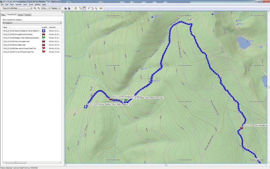
PCT North from Santiam Pass Towards Three Fingered Jack
8.5 miles of hiking • 1250' elevation gain •
It was a very hot day and the burn area in Mt. Jefferson Wilderness afforded no shade. However, as we ascended north on the PCT the wind offered some relief. We stopped often to hydrate. The burn area followed us up the PCT for about the first three miles, and then we reached the treed area. The treed area and wind was amazingly cool and felt wonderful. There was also a stellar view of Three Fingered Jack. Unfortunately, my wife and I must have eaten something bad in the morning as we both started having bad stomach cramps later in the hike! We ended up turning around earlier than intended. Thankfully, the stomach issue subsided after getting back to the TH!
July 2, 2015

.jpg)
.jpg)
.jpg)
.jpg)
.jpg)
.jpg)
.jpg)
.jpg)
.jpg)
.jpg)
.jpg)
.jpg)
.jpg)
.jpg)
.jpg)
.jpg)
.jpg)
.jpg)
.jpg) 1
1
PCT North from Willamette Pass Past Roseary Lakes
10.8 miles of hiking • 1500' elevation gain •
We always like to hike a portion of the PCT while on vacation and had only gone south into Diamond Peak Wilderness from Willamette Pass. This turned out to be a beautiful section of the PCT and well worth the time. The trail from the parking lot to the Roseary Lakes has a gentle slope and is well shaded, which worked well in the heat. The three Roseary Lakes are very beautiful, and Pulpit Rock is a great backdrop for taking pictures. The trail was devoid of hikers for most of the day, and at the turnaround point we met a very nice couple. It turns out we turned around before reaching a shelter. It will be fun to go back and reach this destination!
July 1, 2015

.jpg)
.jpg)
.jpg)
.jpg)
.jpg)
.jpg)
.jpg)
.jpg)
.jpg)
.jpg)
.jpg)
.jpg)
.jpg)
.jpg)
.jpg)
.jpg)
.jpg)
.jpg)
.jpg)
.jpg)
White Fish Trail to Diamond View Lake
10.4 miles of hiking • 1250' elevation gain •
We wanted to hike into Diamond Peak Wilderness and get a good view of the snow capped mountains. A bit of research led to the Whitefish Creek trail and ending at Diamond View Lake.
The drive to this TH was on decent roads and finding the White Fish Horse Camp, where the trail began, was straightforward. However, the TH wasn't obvious, and we had to drive around the horse camp loop to find it. The TH was a bit hidden, but located near an outhouse.
It was a very hot day and this trail had smaller trees that didn't block out the light effectively. In addition, the trail was quite dry and we were kicking up quite a bit of dust.. Whitefish Creek had some water flow within the first mile or so of the TH. After that, the creek was bone dry! Only rocks remained in the creek bed up to Diamond View Lake. I have to admit that we were a bit tired from the previous days of hiking (and high temperatures), so we had a slow time heading out toward the lake.
We reached a pond at about 4.5 miles out, and also got a second wind. At this point, the tree cover was much better and it was cooler, helping us with our energy levels. I started to smell some smoke as we reached Diamond View Lake. It turned out we met our first hiker, and he was painting the gorgeous view of Diamond Peak from the east side of the lake. The view from Diamond View Lake is spectacular and we spent some time taking pictures, and also talking with the hiker/artist. We had a great hike and would like to visit again when there's a bit more moisture on the ground.
June 30, 2015

.jpg)
.jpg)
.jpg)
.jpg)
.jpg)
.jpg)
.jpg)
.jpg)
.jpg)
.jpg)
.jpg)
.jpg)
.jpg)
.jpg)
.jpg)
Horse Lake & PCT Loop Hike
11.7 miles of hiking • 1250' elevation gain •
This was a last minute decision, to visit Horse Lake and spend some time on the PCT. I thought it would be more interesting to make it into a loop hike too. This turned out to be a great decision as there were very few hikers on the trail, except around Horse Lake. We also had the good fortune to meet two PCT through hikers (SheepWagon & Fuego) that had flipped, and were heading south to Ashland (from Santiam Pass). They flipped because the Sierras were forecasted to have very cold night time temps, so they decided to hike a portion of Oregon and then complete the Sierras, and then head north from Santiam Pass to Canada.
June 29, 2015

.jpg)
.jpg)
.jpg)
.jpg)
.jpg)
.jpg)
.jpg)
.jpg)
.jpg)
.jpg)
.jpg)
.jpg)
.jpg)
.jpg)
.jpg) 1
1
Green Lakes Trail Three Sisters Wilderness
10.1 miles of hiking • 1500' elevation gain •
A coworker that is in the Mazamas recommended we try this trail, and it's a gem! What can I say is good about this trail....Everything! What can I say bad about this trail...It's crowded, but the people were dispersed along its length. This trail ranks up there with the finest hikes we've ever had the privilege to experience!
Falls Creek presents you with a huge number of spectacular waterfalls! I started to get tired pulling out my camera and would have just preferred taking movies of the entire hike using a helmet cam. It was a cloudy day with the threat of thunderstorms, but only occasional raindrops fell. The temperature at this elevation probably stayed in the 70's which was quite different than the 90 degree temps back in Bend. As we got closer to the Green Lakes we broke out into flowered meadows and huge lava fields. The views of Broken Top and South Sister on either side of the Green Lakes was so beautiful I could only stand there with my mouth open and soak in the perfection...while constantly taking pictures!
A PERFECT hike and a must to put on the bucket list!
June 28, 2015

.jpg)
.jpg)
.jpg)
.jpg)
.jpg)
.jpg)
.jpg)
.jpg)
.jpg)
.jpg)
.jpg)
.jpg)
.jpg)
.jpg)
.jpg)
.jpg)
.jpg)
.jpg)
.jpg)
.jpg)
.jpg)
.jpg)
.jpg)
.jpg)
.jpg)
.jpg)
.jpg)
.jpg)
.jpg)
.jpg)
.jpg)
.jpg)
.jpg)
.jpg)
.jpg)
.jpg)
Mckenzie River Trail to Tamolitch Pool
10 miles of hiking • 750' elevation gain •
We had originally planned a trip to Yellowstone for 10 days, but these plans were pleasantly interrupted by the potential expected delivery of our grandson in this time frame. So instead, we planned to stay within several hours of home by changing our plans to the Bend/La Pine area. Gratefully, our daughter-in-law gave birth to our grandson the day after our week long vacation ended!!! We were prepared to end our vacation immediately, but the timing of the birth couldn't have been better! Our grandson was born on Monday, July 6 at 3:44pm and both mom and baby have been doing well!!! Sorry for digressing.
Although it was a hot day, the Mckenzie River trail around the Fall area was cool and pleasant! We only planned on hiking south, but changed our destination to the Tamolitch Pool after bumping into some hikers. We hardly saw any hikers on the way out, and it was a pleasant forest hike past the Carmen Reservoir. All the bridge crossings were dry with plenty of shrubs, grasses and flowers growing where we expected water to be flowing. As we approached the Tamolitch Pool, the number of people and noise increased. We came around the trail and reached some cliffs, where we stood above the gorgeous Tamolitch Pool. This blue pool is deep and clear, and the view from above was breathtaking! What wasn't very nice were the HUGE number of people gathered around the pool in their swimsuits. This area felt more like a city swimming pool with yelling and screaming kids. I estimate that there were 30+ people on the shoreline and occupying the cliffs. It appeared that there must be an access trail from the nearby road as we saw none of these people on the trail. I will definitely come back here, but never when school is out!
June 27, 2015

.jpg)
.jpg)
.jpg)
.jpg)
.jpg)
.jpg)
.jpg)
.jpg)
.jpg)
.jpg)
.jpg)
.jpg)
.jpg)
.jpg)
.jpg)
.jpg)
Lacamas Lake Park Hike
4.2 miles of hiking • 500' elevation gain •
Another mid week de-stressing hike. Thank goodness the quarter is over today! This is a very nice area for a leisurely after work hike although the summer weather brought out plenty of people. There were many kids playing in Lacamas Creek but we found some solitude on the southern portion of the park! The smell of the exposed algae from the low water at Lacamas Creek smelled pretty bad, like a dirty aquarium, and wasn't very nice to be around. The waterfalls were devoid of water flow and people were climbing all over the exposed rocks. This park is much more appealing when there is plenty of water and in bad weather when devoid of people. However, it was still nice to get some fresh air!
Thankfully, and as of this writing, the tough quarter at work is over and were hoping to spend a majority of the summer hiking (assuming the heat and fires don't hamper our plans)!
June 24, 2015

Thomas Lake Trail to PCT South
10.1 miles of hiking • 1250' elevation gain •
This is a favorite hike in Indian Heaven Wilderness, and it didn't disappoint today. The parking lot wasn't full, and it appeared that we saw all the backpackers headed back to the TH from Blue Lake. About three hours of our hike was without seeing any people on the trail! The water levels were low and it was weird to not see any snow this early in the season! The Bear Grass was blooming in profusion and littered the forest under the canopy. It looks like there will be plenty of Huckleberries this season as there is plenty of bushes everywhere! No hikers seen on the PCT, but we didn't expect any this early. Exceptional day in a perfect Wilderness!
June 21, 2015
 2
2
Burnt Lake Trail To Zigzag Mt. Trail
10.1 miles of hiking • 2250' elevation gain •
We haven't been to Burnt Lake in a while and decided to head out and experience it again. The road to the TH isn't the best, but we had no issues, and the parking lot was full when we arrived. The trail dispersed the hikers fairly well, but Burnt Lake was crowded (as expected). After admiring the beautiful view of Mt. Hood in the background, we continued on toward the Zigzag Mt. trail.. We headed east on the Zigzag Mt. trail and found a couple of excellent views of four volcanoes! Very enjoyable day and quite cool under the canopy.
June 20, 2015

Steigerwald Widlife Refuge & Dike Hike
5.8 miles of hiking • 0' elevation gain •
A nice mid-week break to get rid of some stress from work. It was surprising that there were so few people on the trail. Water levels were very low. A nice breeze cooled us down.
June 18, 2015

Dry Ridge Trail Roaring River Wilderness
10.3 miles of hiking • 2750' elevation gain •
We intended on hiking the Eagle Creek trail in Salmon-Huckleberry Wilderness, but Harvey Road had a very large tree stump/root ball in the middle of the road! Pissed us off as we traveled a decent distance but had no recourse but to turn around. Perhaps this was the wrong road, but we followed the directions from Oregonhikers.org.
Plan B: We headed out to the Roaring river campground and decided to head up the Dry Ridge Trail towards Grouse Point. The campground was packed, but absolutely NOBODY on the trail! This is a favorite hike of ours and a pretty decent workout for the first 3.5 miles. There's only a couple of views but we enjoyed Grouse Creek (natural air conditioning) and the forest. Plenty of old growth in the first part of the hike along the switchbacks. Unfortunately, we got out late and didn't have time to make this a longer hike.
Spectacular day!
June 14, 2015

.jpg)
.jpg)
.jpg)
.jpg)
.jpg)
.jpg)
.jpg)
.jpg)
.jpg)
.jpg)
.jpg)
.jpg)
.jpg)
Beacon Rock State Park Loop Family Hike
7 miles of hiking • 1500' elevation gain •
Had to work all morning so we wanted a close-in hike since we started late.
It was nice to get out at all today, and we simply did a casual loop hike around the horse bridge and Upper Hardy Creek trail. There was a 25km and 50km running event going on, but it still wasn't very crowded, considering.
June 13, 2015
 3
3
Upper Fanton TH to Tumala Mt and Towards Sheepshead Rock
8.7 miles of hiking • 2250' elevation gain •
Another hot day in paradise! We decided on hiking the Upper Fanton Trail to the summit of Tumala Mt. The summit of Tumala Mt. has a stellar view of Mt. Hood and the Salmon Huckleberry Wilderness. It was also hot up there and we didn't stay long. We then headed east on the Fanton Trail towards Sheepshead Rock. A rock field on the trail afforded an amazing view of the Mt.s and valley, looking south. There were some areas with a cool breeze, but we finally gave up shortly after turning north towards Sheepshead Rock. I believe we made it to the Salmon Huckleberry Wilderness Boundary, but no official sign was seen.
The hike back had a lot of elevation gain, and my wife felt the heat made it a death march, and I found it was definitely a struggle. Still an awesome day with plenty of great views!
June 7, 2015

.jpg)
.jpg)
.jpg)
.jpg)
.jpg)
.jpg)
.jpg)
.jpg)
.jpg)
.jpg)
.jpg)
.jpg)
.jpg)
.jpg)
.jpg)
.jpg)
.jpg)
.jpg) 2
2
Race Tracks Lakes Trail to Red Mountain & PCT
10.4 miles of hiking • 2000' elevation gain •
We finally made it to Indian Heaven Wilderness, and the car survived the drive!
Surprisingly, we were the only car parked at the Falls Creek Horse Camp, and we were the only car parked when we returned! Only one couple was seen during the entire day, and it was an outstanding wilderness hike with almost complete solitude!
The Bear Grass is in full bloom and is all over the place, and there are plenty of other flowers to photograph.
We hiked the Race Tracks Lakes trail and used it to access Red Mountain. It was a fairly warm day, but I'm sure quite a bit cooler than in Portland. The view from Red Mountain was nothing short of outstanding, and we saw five volcanoes from the deck of the tower. The pictures I took just don't do the view justice. For some reason, the deck of the watch tower had very high winds, and it was great for cooling our sweaty bodies. We spent a bit of time just enjoying the view from Red Mt. before heading back down to the Race Track Lakes.
We then took the cutoff trail over to the PCT and then took the PCT south. It was on the PCT that we met the only hikers seen the entire day! The hikers were backpacking and heading to the Race Track Lakes, and we passed them by while heading back to the car.
The mosquito's were not a problem, which we were grateful for!
Fantastic day in the perfect Wilderness. I can't wait to come back!
June 6, 2015

.jpg)
.jpg)
.jpg)
.jpg)
.jpg)
.jpg)
.jpg)
.jpg)
.jpg)
.jpg)
.jpg)
.jpg)
.jpg)
.jpg)
.jpg)
.jpg)
.jpg)
.jpg) 1
1
Bonanza Trail Hike
9.4 miles of hiking • 2500' elevation gain •
We haven't been on this hike for years, and it was about time to explore it again. Unfortunately, the humidity today was overwhelming, and it was taxing to go up the steeper part of this trail.
The parking area is rather small, but we were lucky enough to have a spot for our car! The crossing at Little Cheney Creek was easy since the water level was so low. We've seen this creek look more like a river during the rainy season! The first part of the trail follows along the creek and is fairly level (after the initial climb from the parking lot). The Salmonberry has overgrown the trail in several areas, and needs to be brushed out. I brought some snips, but there's way too much Salmonberry to make a dent.
After about a mile or so the trail starts to climb up to the Bonanza Mine. We took some pictures but didn't go in as it spooks us! The trail climbs more aggressively past the mine, and will offer an excellent workout. As I said earlier, the humidity made this climb a real challenge, and we moved slowly and stopped often for a drink! At about 4 miles out you'll reach a section of the trail that is full of scree. My wife and I didn't like this section as the trail was not in great shape and narrow due to the scree piling up from the erosion. Slipping on this portion of the trail wouldn't have been very fun due to the steep off-trail slope. We think this is an accident waiting to happen for inexperienced hikers, and just our opinion. This area also afforded the best views of the wilderness that we had seen all day.
We didn't go much further than this area as we were somewhat tired from the humidity, and don't typically stay out to late on a Sunday. We bumped into about 7 hikers along the trail all day, and enjoyed the solitude. We stopped about a 1/2 mile short of the trail intersection with Huckleberry Mt..
May 31, 2015

.jpg)
.jpg)
.jpg)
.jpg)
.jpg)
.jpg)
.jpg)
.jpg)
.jpg)
.jpg)
.jpg)
.jpg)
.jpg)
.jpg)
.jpg)
.jpg) 3
3
Zig Zag Trail to Surveyor Ridge Trail Hike
11.2 miles of hiking • 1750' elevation gain •
We decided to head out on the east side of Mt. Hood to hike the Surveyor Ridge Trail. To gain access, we took the Zig Zag Trail. The Zig Zag Trail is a nice workout as it gains 750 feet in the first mile, and you'll go through many switchbacks until you meet an intersection with the Dog River Trail. There is also a trail to a viewpoint of Mt. Hood, but we opted to do this another time as we thought there would be a better view on Surveyor Ridge.
We saw no hikers and about 7 groups of Mt. bikers. All in all the trail was fairly devoid of people, which suited us fine! We took a wrong turn, that led us away from the Surveyor Ridge trail, but we walked the roads to make a large loop that met back up with it. Unfortunately, we went further than intended, and my wife wanted to get back ASAP, so we went straight back to the car (we have a dog at home).
It was a very warm day, but we were mostly under the canopy, and the occasional wind helped cool us down! It was a great hiking day!
May 30, 2015

PCT South into Warm Springs Indian Reservation
12.2 miles of hiking • 1250' elevation gain •
I wanted to end this excellent weekend with a great hike. I proposed that we hike around Timothy Lake, but my wife convinced me it would be full of people and generally crowded and noisy. I was sure she was right, so we opted to hike the PCT into the Warm Springs Indian Reservation. It was an excellent choice as we only saw two groups of people the entire day!
The weather was perfect, and we had a cool breeze cooling us down all day. I regretted having to turn around, but my wife was convinced the traffic would be horrible, and she was all too right! There was an accident near Mirror Lake on Hwy 26 when we were going back. We ended up turning around and taking Hwy 35 to Hood River, and then crossed over into WA via Bridge of the Gods (to avoid the I84 traffic). The traffic back into Vancouver was good except for a stoplight in Washougal. It took over 2.5 hours to get home, and the wife wasn't very happy. :(
What a fun weekend, but only four days until we hike again!!!
May 25, 2015

.jpg)
.jpg)
.jpg)
.jpg)
.jpg)
.jpg)
.jpg)
.jpg)
.jpg)
.jpg)
.jpg)
.jpg)
Wildcat Mt. Hike in the Salmon Huckleberry Wilderness
10.1 miles of hiking • 2250' elevation gain •
It's been years since we've been to this trail and we decided to go there despite the cloudy weather. The Google directions to this TH were excellent and the road is paved all the way until the parking lot, which was gravel. We were the only car there, and we saw NO hikers the entire day! Truly a perfect Wilderness experience!!!
This TH was rerouted and is very nice. It really bothered me that a target range was setup, and went directly across the trail as it wound around the target area several times. These people have absolutely no respect for anything, and are obviously oblivious that they are shooting right into a trail. I'll be calling the Clackamas County Sheriff to report this negligent behavior!
There are some rock outcroppings a short distance in that has a great view of the surrounding wilderness, but we only had a cloudy view for a short time. We could have taken the cutoff to Mcintyre Ridge, but there would have been no view of Mt. Hood. So we continued on along the ridge and further into the Wilderness. There is also a cutoff that takes you to Huckleberry Mt. I would love to hike point to point from the Wildcat Mt. TH to the Wildwood area on Hwy 26, as this would be too long of an out and back for me.
About 4.5 miles out there is a campsite, and a sign pointing to water. I'm assuming there is a spring near the campsite? The only interesting observation about the trail is that there is a huge amount of snags, and this trail would be dangerous in heavy winds. Thankfully, there wasn't much wind today!
I also noticed on my garmin map that it would be possible to hike from the Wildcat TH to Tumalo Mt., passing by Sheepshead Rock (which by the way is absolutely Awesome for a view of the wilderness and Mt. Hood, and some scrambling)!
May 24, 2015

.jpg)
.jpg)
.jpg)
.jpg)
.jpg)
.jpg)
.jpg)
.jpg)
.jpg)
.jpg)
.jpg)
.jpg)
.jpg)
.jpg)
Wilson River Wagon Road Loop Trail Family Hike
9 miles of hiking • 1500' elevation gain •
My son likes to keep our family hikes to about 8 miles maximum, but I goofed. I remember this being a short easy loop with little elevation gain, but he didn't quite feel that way! I think the distance signs are wrong for this loop but they weren't that far off. Although there were plenty of dirt bikes and off road vehicles, it wasn't too bad for the most part. A couple of areas were just fumed out with their exhaust, and the lack of mufflers can be annoying. This is definitely a better winter hike in the snow. Still, we had a good time and were out away from the city and in the forest!
Oh, there's a new bridge over the Devils Lake Fork of the Wilson River, and it's a beauty! I'll put up some pictures after I enter all my weekend hikes!
May 23, 2015

.jpg)
.jpg)
.jpg)
.jpg)
.jpg)
.jpg)
.jpg)
.jpg)
Bonneville Hot Springs to PCT North Past Table Mt.
13.4 miles of hiking • 3250' elevation gain •
Another solo day of hiking, and the weather was amazing! I planned on taking the PCT out for 7-9 miles but got to Bonneville Hot Springs a bit late. Also, I didn't have enough water and had no way to filter it at a stream( I do carry tablets but they take 4 hours for sterilization). I was getting signs of significant dehydration and decided to just turn back. I'm going to have to start carrying a filter as I don't want to carry more than two liters due to weight. I typically don't have this type of issue because my wife and I move more slowly and go shorter distances. I hike a bit more aggressively by myself, but it's typically only a half dozen times a year, and I forget to make changes to my backpack contents.
I have to say that the logging operation NW from Table Mt. is a visual disaster! I have pictures of the area before the logging and it was absolutely breathtaking. I remember hoping that this area would be spared, but I guess that only happens for Wilderness. What a spoiled view. :(
Still, a great hiking day!
May 17, 2015
 1
1
Hamilton Mt. Summit from Horse Camp
13.1 miles of hiking • 2500' elevation gain •
I got to hike solo this weekend as my wife visited her parents. I tend to stay close to home since I'm doing the driving (my wife drives on weekends as I put in 400 miles/week to get to work).
The weather was quite a bit cooler than expected, but I was well prepared for the wind and drizzle. Parking at the horse camp, I hiked the longest path I knew to the summit of Hamilton Mt.! This ended up being the horse bridge trail and then following the Upper Hardy Creek trail. The trail system was almost empty except for the region near the summit. I bumped into some nice hikers and talked a bit, as I tend to do!
Hardy Ridge was cloud covered, so I chose well in heading for the Hamilton Mt. Summit. Table Mt. was also cloud covered, but the Gorge was amazing, as always!
May 16, 2015
 3
3
Ridgefield Wildlife Refuge Hike after Horrible Day!
3.6 miles of hiking • 250' elevation gain •
A somewhat nice ending to an absolutely HORRIBLE day!
We had originally decided on hiking to Red Mt., in Indian Heaven, at the beginning of the day. We were going to start at the Falls Creek Horse Camp off of NF65. When we were about 1/2 mile from the destination, my wife complained that she was pressing down on the gas pedal but the car wasn't accelerating. After about 100ft she stopped the car, and then smoke started billowing from under the hood! She turned off the engine and I opened the hood to find smoke rising from down low. There were no people on the road, and I was thankful we had the satellite phone to call for a tow truck.
Within about 10 minutes after the phone call, two guys in a large pickup stopped and offered to look over the car. The transmission oil had bled out on the ground and all over the exhaust. A liitle bit of history. This is our Subaru that had just been returned from the Alpine Auto body shop about a week earlier! They had replaced the damaged radiator, but NOT any hoses!!! We found this out after the fact. About 1.5 hours later the tow truck arrived from Carson (we had used this service before when our truck got stuck in high snow at this same horse camp!)
A nice older gentleman got out and loaded our Forester onto the truck. He couldn't take us to Vancouver and dropped us off at the Texaco in Stevenson. In Stevenson, we called AAA, which we joined after our Suburban in high snow experience! In about one hour he arrived and loaded our car onto his tow truck. He was an extremely nice person and actually offered to stop and let us hike, or pickup ice cream, since it was supposed to be a Mothers day hike! The tow Truck Driver worked at Riverside Towing in Cascade Locks.
This tow truck driver was very kind and drove us home to pick up another car so that my wife could meet us at Alpine Auto Body. We pulled everything out of the Subaru and drove home. The time was now 5:10pm, and this journey started at about 11:30am. NOT MY FAVORITE EXPERIENCE!
We ate a quick dinner and decided to defuse at the Ridgefield Wildlife Refuge, which is quite an awesome place, especially when we were the only ones there!
Fast forward: The body shop was apologetic but it was obvious they didn't want to claim any wrong doing! He sent us a picture of the ruptured transmission cooling line and another picture of a dent on the newly replaced lower guard. It was obvious that the guard they just replaced was damaged by one of the chain links used to load the car on the tow truck! He claimed the hoses were all good when they were inspected but then said a hairline fracture on the hose area that burst was difficult to see. We argued that the need to replace the damaged radiator would impart a shock on all the hoses. Keep in mind that the car has the original hoses and after an accident would be prudent to replace. It turns out that insurance companies only replace DAMAGED parts and that hoses aren't replaced as a matter of course. I would have paid for the hoses to be replaced anyway if I knew they were going to replace the radiator, and it was already disassembled.
We should get our car back tomorrow, but we'll be taking it to OUR mechanic to inspect the other hoses or replace them.
I should mention that about 7 vehicles passed us while we were waiting for a tow, and everyone offered any help they could give. I guess there is one bright spot in that the people on these forest roads were awesome! I will definitely need to return the kindness if ever this occurs to any unfortunate soul while on the backroads! Another plus is that we had a satellite phone, but the reception on this unit seemed a bit sketchy. The satellites seemed low on the horizon, but I felt it should have been a better signal and easier to lock the gps! I recommend Iridium over the InmarSat phone we have, and we might be switching?
Anyway, sorry about being long winded, but the day ended on a fine note!
May 10, 2015

.jpg)
.jpg)
.jpg)
.jpg)
.jpg)
.jpg)
.jpg)
.jpg)
.jpg)
.jpg)
.jpg)
.jpg) 1
1
Family Hike at Beacon Rock State Park
7.4 miles of hiking • 1750' elevation gain •
We needed a hike close to home so we could get back for a family gathering. We went on this hike with two of our sons. The parking area was packed and the trail system full of hikers. I would have like to summit Hamilton Mt. but they weren't up to it, so we hiked the Hardy Creek trail to the picnic area, and then returned. Gorgeous sunny day and a fun time was had by all.
May 9, 2015

Jackpot Meadow Hike
9.5 miles of hiking • 1500' elevation gain •
We haven't been on this trail for years, and decided to head out and see Jackpot Meadows! There's several trees across the trail but nothing that would slow you down. It would be nice if a trail cleanup crew could look into improving this trail, especially past Jackpot Meadows.
The trail descends down to the Salmon River where there is a well built bridge allowing you to cross. The next portion of the trail climbs about 500ft and then becomes more level. A beautiful stream setting is there to await you, where crossing is easy. The trail gently ascends from here and then levels out before Jackpot Meadows. You'll need to cross a short swampy area that drains from the meadow, but there are rocks to hop most of the way. We didn't get our feet. Jackpot Meadows is surrounded by a waterway, and we didn't try to cross it to get to the actual meadow. The meadow is quite beautiful and the grasses are just starting to emerge!
Our intention was to take the Jackpot Meadows trail all the way to the PCT intersection. However, the trail south of NF-58 has been completely abandoned and is a pain to follow! The trail is covered with a huge number of branches and is a tripping and ankle twisting hazard! This area is also one big mess and looks like a fire hazard. The selective logging here has made a mess of this area, and it would need significant cleanup to be usable!
For some reason I thought we were on the wrong trail, because of the impassibility, and we walked east on NF-58 to get to another trail I had loaded onto our gps. It was about .5 miles away and turned out to be the PCT! I knew we couldn't take this back to our car so we just walked back west on NF-58 and headed north on the Jackpot Meadows trail.
What an excellent warm sunny day on the trail, with no other hikers seen all day!! We were the only car at the TH and so the Salmon River trail must have also been devoid of hikers (Jackpot Meadows and Salmon River trail are at the same parking area).
May 3, 2015
.jpg)
.jpg)
.jpg)
.jpg)
.jpg)
.jpg)
.jpg)
.jpg)
.jpg)
.jpg)
.jpg)
.jpg)
Capitol State Forest Hikes
8.7 miles of hiking • 1500' elevation gain •
This was actually two different hikes in Capitol State Forest. We ended up at the wrong TH and just hiked at the North Creek TH. Unfortunately, there was gun fire just below the trail and so we turned around! The second hike was at the Mima Falls West Trail. It was a gorgeous day and we had a great view of Mt. Rainier from the Mima Falls trail at a clearcut area.
May 2, 2015

.jpg)
.jpg)
.jpg)
.jpg) 1
1
Willapa Hills Hiking West From Chehalis
10.3 miles of hiking • 250' elevation gain •
We decided to go on the Willapa Hills Rails to Trails hike again. This time we started near the Chehalis TH, but parked in the wrong area. We ended up walking down the road to the real TH, which only added about 0.25 miles. The trail is asphalted, but it has an edge that is gravel and much easier on the feet/knees. Thankfully, our knees have been doing better and we're learning how to deal with the effects of arthritis. : ( Hopefully the physical therapy my wife is going through will allow us to be less selective in our hiking locations. The Dr. wasn't too keen on hikes like Dog Mountain or hiking 8 out of 9 days on a week of vacation without more days off. I don't think we'll be doing the PCT anytime soon!
Most of the hike is through farmland and there were about 5 road crossings, one of them being the very busy Hwy 6. Not a very busy trail but there were some hikers and bikers along its length.
April 26, 2015

.jpg)
.jpg)
.jpg)
.jpg)
.jpg)
.jpg)
.jpg)
.jpg)
.jpg)
.jpg)
.jpg)
.jpg)
.jpg)
.jpg)
.jpg)
.jpg)
.jpg)
.jpg)
Coyote Wall Area Hike With Son
7.7 miles of hiking • 1500' elevation gain •
Beautiful sunny day on the east side of the Mt's! My son and I headed out to Catherine Creek but it was so crowded that we couldn't find a parking space!!! I never saw it this crowded. So we just drove to the SW side of the Rowland Lake access to the old road access to the Coyote Wall trail systems. Plenty of colorful flowers and even though it was crowded everyone was nicely dispersed around the trail system. Very little water flowing in any of the streams, but the Poison Oak was everywhere!
April 25, 2015

.jpg)
.jpg)
.jpg)
.jpg)
.jpg)
.jpg)
.jpg)
.jpg)
.jpg)
.jpg)
.jpg)
.jpg)
.jpg)
.jpg)
.jpg)
.jpg)
.jpg)
.jpg)
Frog Lake TH to Clear Lake
9 miles of hiking • 2000' elevation gain •
With such a warm beautiful day we decided to head out toward the Mt. Hood area. Not having hiked to Clear Lake in many years, we decided to park at the Frog Lake parking area and hike this seldom used trail.
Hardly any vehicles at the Frog Lake parking area, which surprised us! So we crossed Hwy 26 on the PCT and then turned left on the Blue Box trail. There was a fallen tree right at the intersection, which will need to be cleared for the through hikers, at some point. This trail was not being maintained and felt more like an animal trail. There were a few fallen trees along the trail, but there is a large amount of Huckleberry growing against the trail. None of the brush or fallen trees were an obstacle, but I wouldn't wear shorts on this trail. We also noticed that there are a huge number of small snags along this trail with very little undergrowth. I wouldn't call this a healthy forest along some of the trail length.
The trail climbs up to a plateau along the first 2 miles, and gains about 550 feet of elevation. The trail loses about 1000 feet of elevation while descending to Clear Lake, and there are a couple of areas that are quite steep (and a great workout). Clear Lake is quite beautiful but evidently vehicles can drive right up to the lake. There was one obnoxious fisherman that had his music pumped up to full volume from his car, and it broke the wilderness like experience on the trail. We also were put off by the cigarette smoking by some other people.
We quickly moved away from this area and found a more secluded area without the music or smoking, and it was a much better experience! We vowed to never come back here except on a bad weather day!!! Still a great day with solitude on the trail!
April 19, 2015

.jpg)
.jpg)
.jpg)
.jpg)
.jpg)
.jpg)
.jpg)
.jpg)
.jpg)
.jpg)
.jpg)
.jpg)
.jpg)
.jpg)
.jpg)
.jpg)
.jpg)
.jpg)
.jpg)
Elk Creek Trail toward Elk Mt.
10.5 miles of hiking • 2500' elevation gain •
Gorgeous sunny warm day and we felt like getting out to the Tillamook State Forest. We hadn't been to the Elk Creek area so we headed out there! The parking area outside the closed gate was almost full and we got one of the last spots on the north side of Hwy 6. There were no cars on the south parking area but it was full when we got back.
The trail is in excellent condition with only a couple obstacles. Almost nobody seen on the trail except for a single large Mazama group. One of hikers called out "Mileage Mike", and I was taken aback. I had met him and his wife near the Indian Point cutoff last year, and he still remembered me! I recognized them but didn't remember their names or where we met.. We had a nice conversation and then headed back to the TH, where we saw them again.
April 18, 2015
 1
1
Towards Tanner Creek Cutoff Trail from Toothrock TH
11 miles of hiking • 2250' elevation gain •
Nice leisurely hike from the Toothrock TH towards the Tanner Creek Cutoff trail. The weather was cool, and refreshing, with very few people on the trail.
April 12, 2015

Seneca Fouts State Park & Post Canyon Trail
7.2 miles of hiking • 1250' elevation gain •
I thought this area would escape the weather forecasted, but no luck. a few storms rolled in and the temperature went down and the wind increased. I was dressed properly but my wife forgot her mittens and my gloves weren't sufficient for her Raynauds. Her hands were very cold and we ended up turning around after reaching Riordan Hill Drive.
April 11, 2015
 2
2
Ruby Beach - Olympic National Park Coast
2 miles of hiking • 0' elevation gain •
It was the last day of our vacation and we wanted to visit the Olympic National Park beaches on the way home. In my opinion, the best coast hike is the Ozette Triangle, but these hikes needed to suffice!
I'll summarize Ruby Beach as gorgeous but very overcrowded! The parking lot was full and the beach swarming with people. We escaped some of the crowd by heading south around a head (that had a few shallow caves), but the crowds soon followed. It was difficult to take any pictures without people in them!
April 9, 2015

.jpg)
.jpg)
.jpg)
.jpg)
.jpg)
.jpg)
.jpg)
.jpg)
.jpg)
.jpg)
.jpg)
.jpg)
.jpg)
.jpg)
.jpg)
.jpg)
.jpg)
.jpg)
.jpg)
.jpg) 1
1
Beach 1 & 2 - Olympic National Park Coast
5.2 miles of hiking • 250' elevation gain •
The tide was coming in during these hikes and so our hiking distances were limited, primarily because we didn't want to hike on the large round river rock that put us above the tide. Also, the beach was being hard on our knees and we ended up just wanting to get home to our own beds!
Beach 1 & 2 are very nice, but there are no sea stacks along their length. Going north from Beach 2 will bring you to Kalalock Lodge, where you'll have to cross the creek (which didn't look bad without shoes, but I opted not to take off my Lowa's).
Beach 1 has a very interesting side trail that is called the Spruce Burl Trail. Spruce Burl's are those large bulging growths found on many of the spruce trees. You can read the info in my picture to learn about it! Beach 1 also had a nice trail going down to the beach, which has a bridge crossing over a stream. The unfortunate part about this trail is that the area is overrun by ivy! The tide was too high to do much hiking by the time we got to Beach 1.
April 9, 2015

.jpg)
.jpg)
.jpg)
.jpg)
.jpg)
.jpg)
.jpg)
.jpg)
.jpg)
.jpg)
.jpg)
.jpg)
.jpg)
.jpg)
.jpg)
.jpg)
.jpg)
.jpg)
.jpg)
.jpg)
.jpg)
.jpg)
.jpg)
.jpg)
.jpg)
.jpg)
.jpg)
.jpg)
.jpg) 2
2
Spruce Railroad Trail to Olympic Discovery Trail
10.1 miles of hiking • 750' elevation gain •
Today started out to be a fantastic day. We started out by visiting Hurricane Ridge to get a spectacular view of the Olympic Mt. Range. It was such a long drive that we weren't able to go hiking until about 2pm in the afternoon.
We decided on the Spruce Railroad Trail as it was very close to Hwy 101 and on the way back to Forks where we were staying. All we expected on this trail was the typical railroad trail, but it was anything but that! The first 3/10 mile is your typical railroad trail, but after that the trail becomes narrow and dives down to track the coast of Lake Crescent. I would vote this as being the least like a railroad trail then all others I have been on! After about a mile the view of Lake Crescent is amazing and you'll get to a steel bridge that spans across a small portion of the lake itself! The bridge is very well built and you can see deep into the clear turquoise water! After that short span of views the trail becomes more of a forest type hike, but you will get views of the lake through the trees. Towards the end of the hike you will come upon the remains of an incomplete tunnel, and the info found online tells you not to go in. I assume the structure is unstable! Towards the end of the hike you will also get more outstanding views of the lake and surrounding mountains. At about four miles you will meet up with the Olympic Discovery Trail, which is paved but with a gravel shoulder to walk on. We followed that for another mile. It's worth looking online for info on the Olympic Discovery Trail as the plans are for this to be a very long trail system!
After such a nice hike, and near sundown, we were driving back to Forks when a large deer walked out in front of our car!!! My wife was driving and it was amazing how she didn't veer off the road or swerve into the oncoming lane to avoid the collision. She braked as fast as possible, but without jamming it on completely, but the deer unfortunately didn't stand a chance and was killed instantly! : ( My wife was practically crying while breaking knowing the deer had no chance, but that veering wasn't an option. The deer had stopped and just stood there watching the car, but paralyzed by the lights, and then the car went over it! Some very nice people stopped and were very supportive, and the gentleman dragged the deer off the road as other cars almost hit it. We called 911 and a State Trooper was there within about 10 minutes. The Trooper dragged the deer off the side of the road down the embankment and into the high grasses. He was very supportive and said my wife had the absolute best response as off to the right was a ditch and wall of dirt and on the left another car and then drop off. The result for us would not have been pretty, and we feel terrible about killing a deer! : (
Fortunately, our Subaru Forester is quite the vehicle in that only some front end damage occurred. No leaks or driveability issues had occurred. We were quoted about $1800 damage by the auto body repair shop, and it's fully covered with no deductible since the damage was due to an animal.
Our dinner plans didn't happen as we got back too late, 9pm, and just barely caught a sandwich before a drive-in closed. What a sad end to a day with a fantastic start.
April 8, 2015

.jpg)
.jpg)
.jpg)
.jpg)
.jpg)
.jpg)
.jpg)
.jpg)
.jpg)
.jpg)
.jpg)
.jpg)
.jpg)
.jpg)
.jpg)
.jpg)
.jpg)
.jpg)
.jpg)
.jpg)
.jpg)
.jpg)
.jpg)
.jpg)
.jpg)
.jpg)
.jpg)
.jpg)
.jpg)
.jpg)
.jpg)
.jpg)
.jpg)
.jpg)
.jpg) 2
2
Hoh River Trail to Happy Four Shelter - Olympic National Park
13.3 miles of hiking • 750' elevation gain •
The Hoh River Trail is a premium forest hike in Olympic National Park and we didn't want to miss it on this trip! We decided to head out for the Happy Four Shelter, which we hadn't seen before. The actual hike to the shelter is more like 5.7 to 6 miles depending on where you park, but we ended up on other trails to add the additional mileage.
This is a beautiful, healthy and vibrant forest with enough old growth to feel overwhelmed with humbleness. The moss hangs like carpets from many trees. The shades of green are so vibrant that it overloads your eyes with its beauty, and the air was cool and scented with freshness. Your senses will be drinking in the pure perfection of this wilderness. There are occasional views of the nearby mountains and plenty of opportunities to watch the mighty Hoh River flow through this paradise!
There seem to be plenty of campsites but I'm sure they're used frequently during peak season, but not today! There weren't many hikers seen on the way out but we did see some larger day hiker groups on the way back. There was only one group of backpackers seen going out on our way back!
Before reaching the Happy Four Shelter we needed to cross a small stream that had no bridge, but plenty of logs for that. The shelter was reconstructed and looked in great shape, and was well worth seeing.
April 7, 2015

.jpg)
.jpg)
.jpg)
.jpg)
.jpg)
.jpg)
.jpg)
.jpg)
.jpg)
.jpg)
.jpg)
.jpg)
.jpg)
.jpg)
.jpg)
.jpg)
.jpg)
.jpg)
.jpg)
.jpg)
.jpg)
.jpg)
.jpg)
.jpg)
.jpg)
.jpg)
.jpg)
.jpg)
.jpg)
.jpg)
.jpg)
.jpg)
.jpg)
.jpg)
.jpg)
.jpg)
.jpg)
Quinault National Recreational Trail Hike
8.8 miles of hiking • 1000' elevation gain •
We spent a fantastic four days (except for another deer collision :(, and I'll go over that in the last TR ) in the Olympic Peninsula during the Washington Spring Break. We stayed in Forks for our basecamp and so decided to stop along the way in the Lake Quinault area for a hike. We didn't expect much from this area since it's near a populated area that is popular; Lake Quinault Lodge.
The Lake Quinault National Scenic Trail is a network of trails that are tied together and can be hiked in small loops, if desired. We decided to make it into a larger loop, as recommended at the forest service station, and began by walking clockwise and on the road, at first. Our first stop was the worlds tallest Sitka Spruce, and it is EXTREMELY impressive with a 58+ foot circumference! This area was crowded and the kids playing and running around the spruce roots really bothered me, with no restraint from mom and dad. We took pictures and left quickly.
We then headed up towards Gatton Creek Falls. It didn't take long to lose the crowds and we saw very few hikers on the remainder of the trail! I should mention that the amount of old growth in this forest is very impressive and worth seeing. Gatton Creek is beautiful and rugged with plenty of picture opportunities. We then turned left at the trail intersection and headed around a small loop while heading toward Cascade Falls. Cascade Falls is another great photo op! Continuing our hike we went through a small cedar bog where a few wood walkways kept us off the wet ground. Upon arriving at the Willaby Creek Trail, we headed up it a short distance before coming to a long wet log that needed to be traversed. It was quite slippery and my wife didn't feel comfortable, so we turned around and continued our loop. I should mention that the Willaby Creek Trail is quite primitive and not maintained, and I would have liked to gone up its entire short 1.3 mile length.
Continuing the loop we soon intersected the self guided Rain Forest Nature Trail Loop, which would be very nice for a family hike. We then crossed the SWouth Shore Road and hiked up another short road to intersect with the shoreline trail. Great views were had on the shoreline. After 8.8 fairly easy miles we returned to the Quinault Ranger Station where we parked. It was a great first hike on our vacation!
April 6, 2015

.jpg)
.jpg)
.jpg)
.jpg)
.jpg)
.jpg)
.jpg)
.jpg)
.jpg)
.jpg)
.jpg)
.jpg)
.jpg)
.jpg)
.jpg)
.jpg)
.jpg)
.jpg)
.jpg)
.jpg)
.jpg)
PCT at Bunker Hill
10.1 miles of hiking • 1000' elevation gain •
It was a great day for hiking and we decided to visit the PCT in the Bunker Hill Area. We also went around the Whistle Punk loop as well as heading up Bunker Hill in addition to the other trails. The only area with people was on the Whistle Punk trail, where the people were yelling to try and find their dog that was running all over the woods. None of the three dogs were on a leash and unfortunately they weren't well behaved and one dog did nothing but continuously yelping frantically! I like dogs (we have one) but these weren't the type to have on a trail without a leash.
April 5, 2015

Columbia Hills Hike to Dalles Mt. Ranch .....Again!
7.4 miles of hiking • 1250' elevation gain •
My son came home for the weekend and wanted to see this area after we talked about it! The parking lot wasn't as full as last week, but then, it wasn't spring break. The weather was great and there was a cool wind blowing the entire day. We had a great hike and were glad to have chosen this area today!
April 4, 2015
 3
3
Columbia Hills – Crawford Oaks Trailhead to Dalles Mt. Ranch
8.9 miles of hiking • 1500' elevation gain •
My wife and I were looking for a new place to go and were inspired by the recent Columbia Hills Hike from Woodswalker! We had tried this hike in 2008 and didn't get anywhere because of the lack of signs and online documentation. The Crawford Hills TH is quite nice, but the parking lot was full, so we parked along Hwy 14. There is a great map on the bulletin board at the TH that I never found online, and it was a big help. We can also attest to the great signage at all trail intersections!
The Balsam Root is at its peak from what I can tell, and the flowers are just a pleasure to see covering the fields in a colorful display. The Dalles Ranch is also a real gem of historical value and it's somewhat eerie walking the grounds. There is a cemetary with both small and large headstones of which most weren't easily readable. There is also a covered area that displayed plenty of pictures of past owners. You can also drive to the ranch on the Dalles Mt. Rd. where a nice new parking lot resides.
Mt. Hood was visible for much of the hike and we could even see Mt. Jefferson until the air quality faded in the afternoon. The wind picked up in the afternoon but it was so warm that the wind was welcome!
This hike was such a pleasure with all its views and opportunities to explore. I highly recommend getting up there soon to catch the flower show!
I
March 29, 2015

.jpg)
.jpg)
.jpg)
.jpg)
.jpg)
.jpg)
.jpg)
.jpg)
.jpg)
.jpg)
.jpg)
.jpg)
.jpg)
.jpg)
.jpg)
.jpg)
.jpg)
.jpg)
.jpg)
.jpg)
.jpg)
.jpg)
.jpg)
.jpg)
.jpg)
.jpg)
.jpg)
.jpg)
.jpg)
.jpg)
.jpg)
.jpg)
.jpg)
.jpg)
.jpg)
.jpg)
.jpg)
.jpg)
.jpg)
.jpg)
.jpg)
.jpg)
.jpg)
.jpg)
.jpg)
.jpg)
.jpg)
.jpg)
.jpg)
Cinnamon & Toutle Trails
9.3 miles of hiking • 2500' elevation gain •
The Cinnamon and Toutle Trails orginate at the Kalama Horse Camp near Mt. St. Helens National Monument. The Cinnamon trail is on a ridge that paralles NF-81 from the Kalama Horse Camp and terminates at Red Rock Pass. There are some spectacular views that can be had of Mt. St. Helens, when it's a clear day, but today was anything but that. We initially drove past Ape Canyon and attempted to access NF-81 so we could park at Red Rock Pass, but the gate was locked! The best views of Mt. St. Helens from the Cinnamon trail are closer to Red Rock Pass, but we abandoned this access point and went back to Kalama Horse Camp.
The horse camp was quite crowded, but the Cinnamon Trail was almost devoid of people, except for two groups of hikers seen during the entire hike! The Cinnamon trail climbs continuously for over 3+ miles and gains over 2000ft, but it's not an aggressive climb compared to some of the Gorge hikes. As expected, and unfortunately, there aren't as many views from the western side of the Cinnamon trail, and the weather didn't help. We did have some great views of Goat Mt and was afforded a glimpse of the base of Mt. St. Helens. There were a few remnant patches of snow at about 4000ft on the trail, but the road (facing north) that climbs to a parking area had a nice slushy snow coat of about 2 inches. The parking area that is just off the trail is obviously used by some shady people as it was littered with shotgun and pistol shells. Shooting in this area is complete negligence, in my opinion, as they would have to be facing the hiking trail or shooting in space past the cliff!
On the way back we did bump into a small group of three hikers that were completely unprepared for the weather and wearing T-shirts and not moving quick enough (more like wandering around) to overcome the elements! The temperature was in the 40's with a slight wind and high humidity (some drizzle). Maybe I'm just getting old with a malfunctioning thermostat! : )
Also on the way back I noticed a tree which was splintered and fallen over. It only took a second before we noticed the shotgun shells at the base of the small tree and closer inspection of the splintered wood revealed tons of buckshot embedded in it! : ( I really don't know what it is about some people that come to these beautiful places and feel it's their right to destroy everything with their guns and leave the ammo scattered everywhere. Absolutely no respect for the environment and probably not concerned about the possibility of shooting hikers that happens to be in the area. This is also the same area that my wife and I came upon a campfire left burning with nobody tending it and in the dry season! Of course, my wife and I put it out. As long as I'm on topic, I should mention that NF-81 is a total zoo during hunting season and I would stay clear during that season!
March 28, 2015

.jpg)
.jpg)
.jpg)
.jpg)
.jpg)
.jpg)
.jpg)
.jpg)
.jpg)
.jpg)
.jpg)
.jpg)
.jpg)
.jpg)
.jpg)
.jpg) 1
1
Yelm to Tenino Rails to Trails Hike
10.9 miles of hiking • 250' elevation gain •
My knee wasn't feeling too well after yesterdays hike, so we tried out a new Rails-to-Trails hike. This trail is 14.5 miles long and is asphalted and is paralleled by a busy road (didn't know it would be). I was hoping there would be either gravel or bark chips on the side of the trail, but this wasn't the case. We tried staying off the asphalt as much as possible but the area on the side of the trail was slightly sloped. We did find a normal dirt trail early on in the hike and this proved to be a very nice experience with a nice stream and mini falls. We even had a nice view of a small lake on this trail. The trail continued but we explored this area on the return and didn't have much time. The area near McIntosh Lake was very pretty though!
It was definitely worth the experience but we'll be staying with the graveled rails to trails hikes (Klickitat/Swale, Deschutes, etc...) in the future. On another note, this is an excellent bike trail and there were plenty of bikers (plenty of walkers with dogs too)!
March 22, 2015

.jpg)
.jpg)
.jpg)
.jpg)
.jpg)
.jpg)
.jpg)
.jpg)
.jpg)
.jpg)
.jpg)
.jpg)
.jpg)
.jpg)
.jpg)
.jpg)
.jpg)
.jpg) 1
1
Triple C to Gales Creek to Step Creek Trails Loops Hike From Reehers Camp
10 miles of hiking • 1750' elevation gain •
We had a house warming party to attend in Gaston, so we decided to hike in the area at Reehers Camp. Very little rain and we only saw one person on the trail at the end of the hike. The Nehalem River was very low but has great scenic value. The Trillium were starting to bloom with plenty of smaller flowers all over the forest floor. A very enjoyable hike in a nice area, but I wouldn't go when Reehers Camp is open due to the horse traffic on the trail system. I'm not against the horses but enjoy it much more during the off season.
March 21, 2015

.jpg)
.jpg)
.jpg)
.jpg)
.jpg)
.jpg)
.jpg)
.jpg)
.jpg)
.jpg)
Sunset Beach Seaside,OR Hike
2 miles of hiking • 500' elevation gain •
I knew there was going to be a storm on the beach, and the winds gusts of 25-35mph I had seen looked tolerable, but it didn't turn out as expected! The winds turned out to be intolerable and down right hurricane strength. We turned around after only one mile after having to duck down to lower our center of gravity due to being pushed around and beat up! On the way back the sustained winds ratcheted up to the point of having trouble walking! This was without a doubt the most brutal hike we've ever been on....Period! Sand was in every crevice of our clothes. The wind noise from our hoods vibrating was deafening and I feel like my hearing was damaged. The only positive thing we got out of this was a good idea of what wind speeds are/aren't tolerable, and another good story. When we got on Hwy 101 I looked up the current wind speeds and found the sustained wind speed was 42mph and gusting at 62mph. We're now calibrated and armed for future windy condition forecasts! Oh, by the way, there were many cars driving on this beach and that wasn't exactly our idea of scenic. There was a woman that offered us a ride back, when seeing us having difficulty moving forward, but we declined since the access road was about 0.2 miles ahead. This was a mistake as the last 0.2 miles felt like 60mph sustained winds!
March 15, 2015

Banks to Venonia Trail
4.8 miles of hiking • 500' elevation gain •
I wasn't very pleased with the failed beach hike so we stopped of to do a bit more hiking on the Banks to Vernonia trail. The wind was still whipping the tops of the trees, which spooked us a bit, due to our near death snag falling experience, but we still managed to enjoy this short hike. We stopped early as my wife was feeling drained from the Sunset Beach wind battering experience earlier in the day! Definitely an interesting day, but we're home and cozy now!
March 15, 2015
 1
1
Stub Stewart State Park Family Hike
8.3 miles of hiking • 1250' elevation gain •
We wanted to stay close to home and with easier terrain for the knee issues we're having. We just kind of wandered around on the trail system, and saw very few people on the hiking. It drizzled for the entire hike and then the rain picked up as we drove away after the hike. We did see a large group of bikers on the Banks-Vernonia trail and talked for a while, and they were very nice people!
March 14, 2015
 4
4
Rampart Ridge & Wonderland Trail Loop & Beyond Mt. Rainier Natl. Park
8.3 miles of hiking • 2000' elevation gain •
With our dog at the kennel for the weekend we felt free to drive a bit further than we normally do for a day hike! We decided on the Rampart Ridge and Wonderland Trail Loop as I thought this would have some great views of Mt. Rainier, and it didn't disappoint! There are plenty of switchbacks going up Rampart Ridge and so the elevation gain was fairly easy. There was a great lookout just after reaching the ridge, and we stopped to take plenty of pictures and drink in the view. Heading further up the ridge we reached an open area that afforded a spectacular view of Mt. Rainier and the surrounding mountains. The ground was still frozen here and some icy snow covered this 100ft stretch of the trail. This was the only portion of the trail that had any signs of snow, and was at about 4000 feet. I believe we were looking at Mt. Ararat and Salulick Mountain area to the northwest? We finally reached the Wonderland Trail and decided to head north toward Kautz Creek. We stopped before descending into the Kautz Creek drainage as we hadn't intended on crossing the creek since it was getting late. We headed back toward Longmire and walked around the area for a while before leaving. It was an awesome day!
March 8, 2015

.jpg)
.jpg)
.jpg)
.jpg)
.jpg)
.jpg)
.jpg)
.jpg)
.jpg)
.jpg)
.jpg)
.jpg)
.jpg)
.jpg)
.jpg)
.jpg)
.jpg)
.jpg)
.jpg)
.jpg) 1
1
Silver Falls Waterfall Loop Family Hike
8.9 miles of hiking • 1000' elevation gain •
We took our son and his wife around the Silver Falls Waterfall Loop. As you would expect on a warm sunny day, this place was a zoo, with 100's of people! We typically avoid these crowds but my it was my son's idea to spend this day here for his birthday, and who am I to argue. Very crowded but the waterfalls here are nothing short of awesome!
March 7, 2015
 1
1
Swale Canyon Klickitat Trail Hike From Harms Road Access
11.7 miles of hiking • 500' elevation gain •
Beautiful sunny day and we decided to hike this wonderful canyon. We only saw about eight people the entire day. Swale creek was gorgeous and many photo ops were had!
March 1, 2015

Porter Creek Area Capitol State Forest
10.1 miles of hiking • 1250' elevation gain •
Beautiful day for hiking, so we headed up to Capitol State Forest in the Porter Creek Campground area. When we arrived there was a large group of people filming a video, and they said it was for an Amazon movie. The whole thing was quite strange and one of them told me I couldn't take pictures. Everything about this spelled amateur, and we started the hike ASAP as a couple of them were smoking, and it stunk!
We first headed out to Porter Creek Falls. It was a very nice short trail, except when we arrived there was a fire roaring at the viewpoint, and lots of trash was scattered around the area. We quickly took pictures and then left, but bumped into the teenagers that trashed the area. We didn't say anything and just left the area quickly.
We next headed out on the North Rim trail, which started about 0.4 miles down the road and northeast of our parking area. Once on this trail we only saw one mountain biker the remainder of the hike! There were plenty of puddles on the trail but they were easy to step around. Only a few areas with views, but the views contained clear cuts from the logging operation. All in all, a nice day!
I tried out a new camera today and so far am very pleased with it. I'm trying to lighten my load and the SLR setup I was carrying weighed in at about 4 pounds! This Sony RX10 camera only weighs 1.8 pounds, which puts much less stress on my shoulder.
February 28, 2015

.jpg)
.jpg)
.jpg)
.jpg)
.jpg)
.jpg)
.jpg)
.jpg)
.jpg)
.jpg)
.jpg)
.jpg)
Mima Falls Trail West to Lost Valley Loop Capitol State Forest
9.4 miles of hiking • 1250' elevation gain •
Most of the time we don't see many people on these trails, but today was different. The great weather brought out some mountain bikers, hikers and a trail runner. It still only amounted to about a dozen people we saw for the entire day!
We really enjoy this area and the hike around this mountain is very enjoyable. There were some muddy spots on the trail on the west side but it was only a bit annoying.
There is a huge trail system at Capitol State Forest but since it is multi-use there are all sorts of things going on around here (not unlike Tillamook State Forest). It's a long drive from Portland but in my opinion worth it for the variety. All trails are very well marked.
February 22, 2015
.jpg)
.jpg)
.jpg)
.jpg)
.jpg)
.jpg)
.jpg)
.jpg)
.jpg)
.jpg)
.jpg) 2
2
Twin Lakes Loop Hike
8.1 miles of hiking • 1000' elevation gain •
We decided to take advantage of minimal snow below 5000ft and try out the Twin Lakes Loop. There were about 8 cars in the Frog Lake parking lot. There were a few snow flakes falling when we started the hike and on the way back to the TH! Too bad this couldn't be a snowstorm dumping.
This area has always been special to us and today wasn't any different. Very few people on the trail except when returning past the lower Twin Lakes trail intersection on the return trip using the PCT. When we arrived at lower Twin Lakes there was a group of boy scouts hanging around and enjoying the cool partly sunny weather. They typically have a snowshoe trip about this time every year but still decided to camp out in spite of minimal snow. Lower Twin Lake has a layer of ice on the majority of its surface except for the northern shoreline. The ice isn't thick enough to walk on but it was very cool to see!
We then took the trail to Upper Twin Lake and again, there was a layer of ice on most of the lake. Nobody was at this lake and the view and solitude were amazing! Hiking north around the loop we encountered the most snow seen on the trail. The patches of snow on the trail were dense and hard and a bit icy but not an impediment. We finally reached the northern intersection with the PCT on this loop and then headed south back to the TH. A totally enjoyable hike that isn't typically hike-able in February!
February 21, 2015

.jpg)
.jpg)
.jpg)
.jpg)
.jpg)
.jpg)
.jpg)
.jpg)
.jpg)
.jpg)
.jpg)
.jpg)
Tam-A-Lau Trail & Beyond Cove Palisades State Park Lake Billy Chinook
9.2 miles of hiking • 1250' elevation gain •
Our last hiking day of this long weekend and we wanted to finished it with another great hike! We decided to head out to the Lake Billy Chinook area and hike the Tam-A-Lau trail. It was quite cold this morning and thankfully the trail to the mesa was frozen solid, even when we returned. Climbing up the wall of the canyon leads to ever more scenic views of Lake Billy Chinook. During the ascent Mt. Washington, Jefferson and the northern part of the Three Sisters come into view. Once you get to the top of the mesa the view is nothing short of breathtaking!!! I could hang around those cliff walls all day and drink in the beauty! The loop trail on the Mesa takes you along the cliff walls for all but the return path. The trail is actually more like a triangle in shape.
We believe there are petroglyphs somewhere in the park but never really pursues the location. It would be interesting to come back and hunt them down as I've seen pictures that look very cool! The Tam-A-Lau trail is only six miles long, so we continued to explore the shoreline along Lake Billy Chinook. There were a few fishing boats out on the lake, but otherwise, we only saw one family and a single hiker with a dog the entire day. The park was open (and there is a fee) but the campgrounds were closed.
We did see one group of deer while on the mesa, and one group of deer in the campground while driving out of the park!
This place is quite beautiful and the Tam-A-Lau trail is definitely worth visiting!
February 16, 2015

.jpg)
.jpg)
.jpg)
.jpg)
.jpg)
.jpg)
.jpg)
.jpg)
.jpg)
.jpg)
.jpg)
.jpg)
.jpg)
.jpg)
.jpg)
.jpg)
.jpg)
.jpg)
.jpg)
.jpg)
.jpg)
.jpg)
.jpg)
.jpg)
.jpg)
.jpg)
.jpg)
.jpg)
.jpg)
.jpg)
.jpg)
.jpg)
.jpg)
.jpg)
.jpg)
.jpg)
.jpg)
.jpg)
.jpg) 1
1
Oregon Badlands Wilderness Hike
12.6 miles of hiking • 750' elevation gain •
We've been to this Wilderness before and love its solitude and beauty! The parking area was full (about 8 vehicles) and we saw most of the people in the first hour on the way out.
We started out going north on the Ancient Juniper trail and then turned left and continued on the Flatiron Trail. At about 3 miles out from the TH there is a raised bed of lava. There is a trail, on your left, that climbs up into this area and will take you to a fantastic viewpoint where the Central Cascades are visible! Very much worth seeing! After spending a bit of time taking pictures, we continued north on the Flatiron Trail.
We continued on until we reached the end of the park. The only thing to see there was a barbed wire fence with a sign indicating Private Land. However, what amused us were the dozen Bison all looking at us on the other side of the barbed wire! It was hysterical as they watched us looking for a way onto the road away from the private land, but none existed!
On our way back we bumped into three women that were looking for the Flatiron viewpoint. We told them they had hiked about 2+ miles past the viewpoint. They stopped and rested but we needed to hurry back before sunset. On our way back we put an arrow in the gravelly soil and my wife sketched the word ladies next to it. It turns out they took the short way back and we both arrived at the TH at the same time! They thanked us profusely for the sand sign and showed us a picture they took of it!
Another great place to hike with plenty of trails, but make sure to go there when it's cool!
February 15, 2015
 1
1
Smith Rocks State Park Loop Hike
8.3 miles of hiking • 1500' elevation gain •
My wife and I decided to get away for the long weekend to the Central Cascade area since it was going to be warm and sunny! Our first stop was to Smith Rocks State Park. We had never been here before and didn't know what to expect. When we drove in from the west on Wilcox Avenue and then turned left on Crooked River Drive we were astounded. There were literally HUNDREDS of vehicles along the roads and in the Full parking lots. The only place we've seen it this busy was in the popular national parks! We decided to drive towards the full parking lot area and were amazed that a couple was pulling out just as we arrived! What luck!
The only way to describe this area is amazing, and I don't just mean the amount of people. I couldn't stop taking pictures! Our knees were in no condition for Misery Ridge, but we'll have to go back for that fun looking ascent, which by the way was swarming with people. Instead, we went from the parking lot toward the horse crossing at the Crooked River. We then proceeded on a clockwise path around the entire park. We needed to use the bridge to cross over the river to complete the loop. The people were everywhere, but for some reason it didn't make a difference. We kept stopping and taking pictures of the amazing scenery! We also stopped to watch the multitude of climbers scaling the walls, and they were everywhere!
Once we headed around the SW boundary of the loop we caught our first glimpse of the pillar Monkey Face! This is one serious monolith, and there were three climbers ascending it! The Misery Ridge trail on the west side of the park is an easy climb to the top, but I'd start on the eastern side as it's appears a bit more aggressive. To continue the loop, we veered left at the Misery Ridge intersection and continued on around into private land. We were amazed that the crowds had gone to practically zero, and we only saw about five people for the remaining 4+ miles!
After going through the private land, the trail climbs through a seires of switchbacks around all the spires at the nort end of the park. I think the views here are also fantastic and worth seeing. You can see the volcanoes along the central cascades and nearby mountains. The trail finally intersects Burma Road and from there you descend on one long switchback, and then meet with another short trail to descend along the Crooked River. We then hiked along this trail and back to the bridge where we completed the loop.
When we were descending down Burma Road, the sun was setting, and the sunset colors on the hills to the east of us was absolutely breathtaking! It was dark when we arrived at our car, and you could see dozens of lights descending down the Misery Ridge trail, and this was magical! Also, on the return along the river there were still dozens of climbers on the various walls with plenty of laughter.
This place is a gem and should be on everyone's must see list!!!
Pictures for all these hike are forthcoming, but work starts early am tomorrow. :(
February 14, 2015

.jpg)
.jpg)
.jpg)
.jpg)
.jpg)
.jpg)
.jpg)
.jpg)
.jpg)
.jpg)
.jpg)
.jpg)
.jpg)
.jpg)
.jpg)
.jpg)
.jpg)
.jpg)
.jpg)
.jpg)
.jpg)
.jpg)
.jpg)
.jpg)
.jpg)
.jpg)
.jpg)
.jpg)
.jpg)
.jpg)
.jpg)
.jpg)
.jpg)
Stub Stewart State Park Hike
9.6 miles of hiking • 750' elevation gain •
In keeping with hiking on knee friendly trails, we went to Stub Stewart State Park. We've only been there once and all I remembered was being on a paved trail. This trail was the Banks to Vernonia trail. It turns out that this trail system is quite extensive and will take many visits to complete. Plenty of hikers on the Banks to Vernonia Trail but nobody on the remainder of the trail system. We're thankful that this hike was fairly easy on the knees, but my wife still had some issues and needed ibuprofen.
February 8, 2015

Willapa Hills Trail
11.3 miles of hiking • 250' elevation gain •
My wife and I are having knee issues from last weeks hike and so we decided to take it easy for a while. We really enjoy this rails to trails hike and decided to hike for a second weekend. The trail in this region is primarily surrounded by trees with many views of the Chehalis River. The river was muddy and quite high but definitely not at flood stage. We had a strange experience in that a dog followed us from the TH for about 2.5 miles. It was a cute chocolate colored dog and it had a tag. The dog ended up chasing another dog (from a nearby farm) and we didn't see it again after that! We would have tried to contact the owner if it followed us the entire day. The rain was heavy at times but we also had a brief visit by the sun.
February 7, 2015

Rainbow Falls State Park & Willapa Hills Trail Hike
9.6 miles of hiking • 250' elevation gain •
My wife and I both had knee issues today so we decided to try something new. I looked up the rails-to-trails hikes and found the Willapa Trail hike which can be started out of Rainbow Falls State Park. Rainbow Falls is more like a rapids area, and the river crossings have both been washed out and won't be replaced. I know this because the Park Ranger mentioned this in a conversation. As a result, we didn't visit the southern portion of the park that contains all the Old Growth. Instead, we headed out on the Willapa Hills trail and headed east. The nice thing about this trail is that all remnants of the railroad were removed and the trail bed has a foundation of pea gravel, unlike the larger rock of the Klickitat trail. The first portion of this trail travels through farm land. After we made the turn south, in about 3.5 miles, the trail had trees surrounding it with a view of the Chehalis River.. A great easy trail for those days when you want an easy but scenic trail! By the way, this trail when completed will be a continuous 56 miles in length between Chehalis and South Bend WA!
February 1, 2015

.jpg)
.jpg)
.jpg)
.jpg)
.jpg)
.jpg)
.jpg)
.jpg)
.jpg)
.jpg)
.jpg)
.jpg)
.jpg)
.jpg)
Monte Carlo Trail to Buck Creek Loop Trail
8.9 miles of hiking • 2500' elevation gain •
I didn't believe the weather report for this area because it's almost always wrong. I made a mistake this time and left behind some of the warmer clothes, but what I had held up! It was cloudy and in the high 30's at the TH. We headed up the Monte Carlo TH and before we reached the intersection with the Buck Creek Trail the temperature dropped below freezing and there was a freezing fog all around us. The ground wasn't yet frozen but there was evidence of ice heaving. There were piles of ice pellets at the base of many of the trees. There were only a couple of spots that had snow remnants and last time we were here there was a couple of feet of the white stuff. No people were on the trail and the fog added a magical touch to the ambience! No views were present. I apparently tweaked my knee again, going under a tree, and I'm a bit frustrated with how frail it appears to be after all the hikes we do. The Monte Carlo trail only has a few trees across it and is in great condition. The Buck Creek trail we hiked on really needs a brush out but is still easily traversed! Great day in the clouds!
January 31, 2015

Henry Hagg Lake Hike
12.2 miles of hiking • 1250' elevation gain •
Absolutely gorgeous day and the fog stayed away from most of this area. We took longer than expected to get here and found Hwy 26 to Hwy 47 south is the fastest way to this lake. We really didn't have the time to go completely around the lake but this would have been easy if we just had the extra 1-1.25 hours. We first hiked around the lake when we started hiking again, in 2008, and it was a death march for the last 4-5 miles as our feet were on fire. Today this hike was fun and our feet held up very well. What a difference getting in shape and time makes! For those interested, the entire Henry Hargg Lake loop clocked in at 14.4 miles when we hiked it in 2008, but the GPS we had then lost the satellites twice.
The trail was for the most part in great condition, but a few areas were just full of soft mud which caked on our shoes. We saw some trail runners and people on bikes, but the trail system was fairly devoid of people. The views are very nice, but I could do without some of the clear cuts.
January 25, 2015

.jpg)
.jpg)
.jpg)
.jpg)
.jpg)
.jpg)
.jpg)
.jpg)
.jpg)
.jpg)
.jpg)
.jpg)
.jpg)
.jpg)
.jpg)
Battleground Lake State Park Family Hike
5.8 miles of hiking • 1000' elevation gain •
We haven't been here in decades, and now I remember why. The smell at the parking lot and around the lake wasn't pleasant! It was crowded around the lake with plenty of people fishing but the trail system was devoid of hikers, and only a few groups on horseback were seen. We enjoyed the trail system but it was a bit muddy in places. There is plenty of road noise around the periphery of the park which detracts from the ambiance! There are plenty of trails you can wind around but it doesn't add up to much distance. This park might not be too bad in bad weather as it would limit the number of people here and fill the lake with some fresh clean water, but we won't be coming back soon. I would have gone much further but my wife and son couldn't stand the smell in the vicinity of the lake, and I lost interest in continuing. I also had the unfortunate luck of picking up a couple of freshly recharged NiMH batteries that were defective. As a result, I had to paste together the track from two different GPS's, but still lost some of the track (about a 1/2 mile). I've also been fighting a foot infection that has plagued me for about 2 weeks. Today just seemed to be the convergence of many unfortunate factors. Oh well, tomorrow were going to try a much longer hike while the weather is warm!
January 23, 2015

.jpg)
.jpg)
.jpg)
.jpg)
.jpg)
.jpg)
.jpg)
.jpg)
.jpg)
Milo McIver State Park Hike
8.8 miles of hiking • 750' elevation gain •
Very rainy day to start off but it stopped before we left. Very few people on the trail, and most were fishing. The Clackamas River was quite high and there were plenty of views!
Unfortunately, my Garmin 60CSx died today! It's served us well for many years and it will be missed. I've always enjoyed that the mileage you see on the track is what you get after the download. I can't say that about any other GPS I've used, and I've tried almost all of them. (Monterra, Montana, Oregon, 64st, etrex, etc...) The newer models are much better in canyon's and under dense tree cover (especially with Glonass) but they accumulate mileage even when not moving. The Basecamp software, in my opinion, lies about the data by displaying what you see on the screen, but every other software I've used shows this mileage to be incorrect. Garmin simply has no other real competitors (except smartphones) and appears to put out buggy products. I'll be using a 64st and etrex30 but have looked into other products (Trimble, Delorme), but there aren't any real alternatives. Smartphones use too much battery power and don't seem to reliably record the info. I will say that my Canon GPS module (fits on hotshoe) is very reliable but has no display, but I can download the track after use.
January 18, 2015

.jpg)
.jpg)
.jpg)
.jpg)
.jpg)
Catherine Creek Area Hike
8.5 miles of hiking • 1500' elevation gain •
I thought we'd go east to avoid some of the rain, so we went to the Catherine Creek area. Unfortunately, it rained hard most of the day! Streams/creek weren't very high, but I'm sure that will change tomorrow. There were no people on the trail and we liked that very much. Saw a total of 8 deer in three separate groups and this was amazing. The last deer we saw had a damaged back leg and I don't think it will make it much longer. : ( We felt very bad that there was nothing we could do as it hobbled away from us, and this was very depressing. Our clothes were saturated and all gear will need to be dried before tomorrows hike.
January 17, 2015

.jpg)
.jpg)
.jpg)
.jpg)
.jpg)
.jpg)
Millersylvania State Park Hike
9.7 miles of hiking • 500' elevation gain •
This is a really nice state park and we pretty much hiked all the trails today. There's some old growth and a nice (but slippery) boardwalk above some swampy lowlands. There's even a fitness trail with bars for doing other exercises. I wouldn't approach this park during the summer months as it would be crowded, but it's fairly empty now with only a half dozen groups seen.
January 11, 2015

Storey Burn Loop Hike
9.1 miles of hiking • 1750' elevation gain •
Beautiful day out in Tillamook State Forest on the Storey burn trail! We parked in the Rogers Camp area and it was quite loaded with ATV and dirt bike riders. The exhaust fumes and noise were quite bad but we quickly escaped both once on the trail. We headed counter clockwise past the Gales Creek Campground. Plenty of cars parked in the Gales Creek TH area but we saw no people that originated from here. The trail is in excellent condition and we only saw two groups of hikers (both friendly) all day. It's been a while since we've been here and it was nice to do this fun loop again. Only a few rain drops fell toward the end of the day.
January 10, 2015
 1
1
Salmon River Trail To Viewpoint in the Wilderness
8.1 miles of hiking • 1250' elevation gain •
Very rainy day but it was a wonderful Hike. The Salmon River Trail is one of our favorites! One trail runner on the trail on the way out but two couples and a trail runner on the way back. Plenty of icy patches on the trail and we decided to wear the Kahtoola's, which worded out well, although on the way back the ice was melting out. Water levels were low and all streams were very easily crossed. The viewpoint showed that only a dusting of snow is present everywhere. A very fun day but we were waterlogged in spite of the rain gear.
January 4, 2015

.jpg)
.jpg)
.jpg)
.jpg)
.jpg)
.jpg)
.jpg)
.jpg)
.jpg)
.jpg)
.jpg)
.jpg)
.jpg)
.jpg)
.jpg)
Trails Originating from Eagle Creek
8.6 miles of hiking • 2250' elevation gain •
We rolled into the Eagle Creek parking lot and as expected there were many people arriving and hiking up the trail. We headed east on the Gorge #400 trail and then headed up the Ruckle Creek Trail. I'd never been there before and was soaking wet after only 0.6 miles. My wife and I decided to head back onto the #400 trail and perhaps save it for a nicer day. We then headed towards Dry Creek but turned around when it started getting late. We then headed up towards Buck Point, out of the Eagle Creek Picnic area. We ended up heading back to the TH as me and my wifes knees were starting to bother us. Darn knees started to hurt us on the Asphalt of the #400 trail! on the way out! We don't have nearly the problems when just hiking the dirt trails. Turns out we both need physical therapy for knee issues, but I've been lazy about spending more time and money.
January 3, 2015

.jpg)
.jpg)
.jpg)
.jpg)
.jpg)
.jpg) 1
1
Gnat Creek Trail Hike
9.2 miles of hiking • 1250' elevation gain •
Great Hike at Gnat Creek! We hiked the entire trail with some additional trails and bushwacking. Streams on the trail were flowing but very low. A section of the trail was frozen solid but didn't require any traction devices. Absolutely no people on the trail!
January 2, 2015

.jpg)
.jpg)
.jpg)
.jpg)
.jpg)
.jpg)
.jpg)
.jpg)
.jpg)
.jpg)
.jpg)
.jpg)
.jpg)
Molalla River Recreation Area Hike Huckleberry Trail
10 miles of hiking • 1500' elevation gain •
Beautiful sunny and cool day in a less used hiking area. Got out a bit late due to staying up late, but a nice hike that is also close to home.
January 1, 2015
