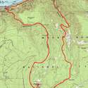
18 miles of hiking • 4500' elevation gain •
We started at the Multnomah Falls parking lot and traversed Gorge Trail 400 a couple of miles to connect with the Oneonta Gorge trail 424, then followed that trail up to Franklin Ridge and then south, turning left at the junction with the Horsetail Creek trail (445), continuing on 424 to the junction with the Bell Creek trail, and turning right and following the trail as it swings right and onto the little ridge that leads to the summit. No snow whatsoever until past the junction with trail 444, around 3500 ft. Then just patches until you pop out on the road - there's a lot of meltout, but there are some big snow areas to cross as you go up to the parking lot (which is mostly under snow). The good news is this snow is only a foot or two deep, and will probably all be gone in a couple of weeks. From the parking lot, the best bet is to head uphill past the picnic sites (since the lateral paved path to Sherrard Point is very snowy) and then go down the other side of the bump to the steps to the top, which is totally clear. Basically, any place that doesn't have tree cover still has snow on it, but anywhere where trees reduced the snow accumulation is clear now. Expect Larch Mountain to be snow-free very soon.
The day was nice and there were good views of Hood, Adams, and Helens. Rainier was partly visible. The Larch Mountain Road gate is apparently still closed, but right after we got to the summit, hordes of people arrived who'd parked at the gate and hiked up. It became very crowded...
We went down the main Larch Mountain trail 441 all the way back down to Multnomah Falls, closing the loop. I don't have exact stats for this hike, but I'm estimating something like 18 miles from maps on NWHiker and PH lists 4400 ft gain for the Oneonta approach - we just added a couple of miles of warmup. If anyone has more specific GPS stats or anything like that, I'm all ears.


