

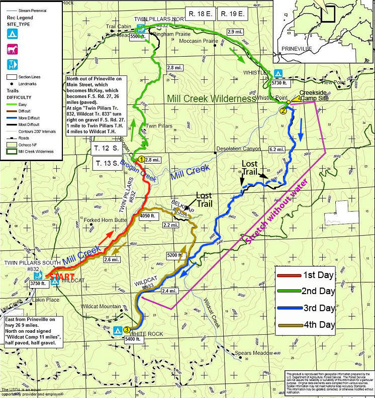
27 miles of hiking • 3500' elevation gain • 3 nights
Last May I did a hike to Twin Pillars, and since then wanted to do a whole 27-mile loop which covers all trails in this small wilderness. I planned the trip in May, but the combination of late snow and finals held the trip until now. The conditions were uncertain - on one hand the trail to Twin Pillars was overgrown with brush last year (and it's the most popular trail, so I had to expect the rest of the loop to be quite obscure), on the other hand Forest Service site said last summer that all trails are currently undergoing repairs. As it turned out, so far they only repaired the trail along lower Mill Creek (the first 3 miles) and the lower third of Belknap Trail #833A; the rest of the trails didn't see maintenance at least in the last decade. I am glad I planned 4 days on this trip! Unlike the description in FieldGuide, I did the loop clockwise.
DAY 1
Upon arriving at South Twin Pillars trailhead on Friday at 7:40 pm, I started up the trail to my stealth camp 4 miles in, where I camped last spring. In fact, there are many places to camp along Mill Creek in the first 3 miles or so, but I wanted to get a little more uphill on the first day. The stretch along Mill Creek is one of the most beautiful in the wilderness; it was mostly spared by fire (which burned most of the wilderness in 2000). The creek valley is lined with sparse ponderosa and fir forest, and there are many flowers along the trail (some small variety of balsamroot, larkspur, red columbine, blue lupine, to name a few). After several creek crossings (there are 8 crossings in total; you may easily skip 3 in the beginning, and there is a good log just above the upper crossing, so you have to wade about knee-deep 4 times across Mill Creek) and after a short uphill climb I crossed Brogan Creek and headed east off-trail over a small ridge to my campsite. The forest is all burned down at this point, but behind that ridge there is a piece of forest that survived the fire, with ponderosa pines and a nice meadow with a tiny stream to get water from (I expected it to dry out so I brought the water from Brogan Creek). I just like this secluded campsite even though it required getting over blowdown.
I set a camp in the dark using my LED headlamp, let my dog into the tent, built a fire and went to hang a bear rope when I noted we are not alone. In the light of the headlamp I saw two pairs of eyes watching us from just 100-150 yards away, in the direction I was heading. It was impossible to see who it was, but I knew those were not deer or cattle because I could see both eyes even if they turned head. I took a large stick and headed towards them to my "bear tree", making as much noise as I could, but the animals didn't run away as I expected. One of them kind of looked at the other and then they both watched me again. They were still too far to see, but at the same time too close for comfort; it was a little creepy. I remembered seeing cougar scat just 50 yards from my tent there last spring, and it looked as I set a camp right in their "living room". I hung my bear rope without putting a stick too far aside. When I was done with the dinner and hung my bear bag the eyes still watched me from the same spot.
It was a cold night (the forecast said 34F and it felt like this) but I took a plenty of extra clothes and it was OK.
DAY 2.
In the morning, my campsite looked just beautiful and peaceful - red ponderosa pines, green carpet of short grass dotted with flowers, birds chirping, not a single mosquito or biting fly. I would probably camp there again, but will make sure I'm done with everything by the dark. It warmed up really quickly - at 6 am it was as cold as it gets, but by 9:30 I was without a shirt already. It's fun to set a fire - there is a ton of perfectly dry wood on the ground that starts burning in a few seconds (I checked that there was no fire restrictions before heading out, but still it's better to be careful). I took tea bags with me, but ended up making wild strawberry tea - the strawberry plants are everywhere. The next day, I added fireweed to strawberry leaves, and after the tea was ready I put in oatmeal and raisins - it turned out to be a great recipe.
As we climbed towards Twin Pillars (two large rock spires raising above the forest of snags), the trail became very overgrown - only about 200 yards at the bottom have been cleared. There were markings from Forest Service contractor, which probably means they are going to do this section this year. The climb through brush and blowdowns was very slow and in just 1.5 miles I really felt tired. Above Twin Pillars the brush ends, but heavy blowdown (every 20-50 yards or so) continues for about a mile more - it was like Steeplechase barrier running with a 25lb backpack. After this, it was mostly easy blowdown (step-over) and I enjoyed the easy trail, periodically slapping mosquitoes. The trail becomes almost flat as it goes over the highest point of the loop - 5,800 feet. There is a lot of wild onion in bloom, but I don't know which part of the plant is edible. Soon there were views of a nice rocky canyon on the right, dozens of chipmunks among fallen logs kept my dog entertained (no she didn't catch any, they're too fast). At the north end on Twin Pillars trail, per Field Guide, there's a "nice view of Bingham Prairie, where you might see wildlife". And man - those swampy meadows had so much "wildlife" I almost forgot about the views (sure it wasn't meant moskitoes in Field Guide but that what I got)! Any time I slowed my pace I was engulfed in a cloud of HUNDREDS of buzzing pests; they were so hungry that tried to bite before they could properly 'land' on me. There was a moment when I had to cross a 5-steps wide stream on a log using both poles for balance - during those 5 steps I got more than a couple dozen bites. As I didn't take any kind of insect protection, the only choice was to increase the pace and hope the rest of the loop isn't like this. The trail description said there was a nice outhouse at the north trailhead, and all my dreams were to get into the outhouse, as soon as possible, slap the door closed and stay there for 20 minutes or more.
However, the trail got to the road about 1/4 mile west of the trailhead, and once I saw a turn-out to picnic area I decided to continue east on the road. The skeeters ended soon after I passed the meadow area, and a 3-mile walk on a little used road was pretty good. There were a couple of "views" through trees in the direction of Painted Hills, but otherwise it's just a nice forest walk. About 1/10th of a mile before North Wildcat TH, there is a road sign pointing right to Wildcat trail, and it was in fact looking like an overgrown trail there. Skip this (if you head there) - the trail starts at the end of road 500 (? not sure about the number) where you turn right from the main road, soon after that sign. I continued an easy mile downhill to the headwaters of Mill Creek. With all the small streams running I had no worry that headwaters of Mill Creek will dry out, and in fact it had so much water that I skipped the creekside camp site (quite good) because I thought it would be hard to sleep with so much water noise. Strangely, Mill Creek has absolutely no mosquitoes - it is either too fast, or too cold at that location. I camped just off-trail on a ridge overlooking (through a few snags) Desolation Canyon and Three Sisters, Broken Top, and Bachelor - it made for quite nice sunset and sunrise watching.
DAY 3
It's so good to wake up every day to sunny skies! Also, it felt great as I kicked off half of the distance in the last 2 days (despite the late start on Friday) and half the elevation in the last day alone. I quickly packed up, made a run for water at Mill Creek, and headed south along Wildcat trail. The trail indeed looks "less used" and is overgrown with grass (it seems there was no one in many days or even weeks), but it's easy to follow and has comparably little blowdown. For the next mile I had great views of Desolation Canyon - the forest mostly burned down there but the canyon looks green with brush (same kind I was bushwhacking in the previous day). The brush tries to reclaim the trail in a few spots but it's not bad yet. The trail makes a way along the ridge and has no water for about 6.5 miles. In about a mile the trail got pretty bad, completely covered with blowdown and brush, but then it goes to through the gate in wire fence to the east side of the ridge (not burned in 2000 fire) and alternates between the mixed pine-juniper forests and small meadows with balsamroot (already starting to fade), larkspur, and lupine (just starting). There were great views to green Ochoco Mts to the east. One of the nearby higher peaks (Lookout Mountain?) still has a fair amount of snow near the top. I lost a trail couple of times because it gets really faint, but since it follows the ridge I was never "lost". About 1,5 miles before Belknap junction the trail gets in a postcard-perfect ponderosa pine forest with a mix of firs in places. There were a few spring morels (I only write this because no one in my family likes them) and a lot of strawberries in bloom. The upper junction of Belknap Trail is well signed (BTW, there were new signs on all trails). The White Rock campground has only 2 spots, but being Sunday evening it was empty. It's quite nice place to camp - huge ponderosas, a lot of firewood, outhouse, and running water (though it has iron after-taste - it's better to get water from a stream 1 mile before the campground). Despite numerous warning signs about cougars in the campground, I didn't see any glowing eyes this evening.
DAY 4
It was supposed to be an easy day, 7.2 miles, mostly downhill. I backtracked on Wildcat trail to Belknap junction and headed down on Belknap trail.
It has a fair amount of blowdown for the first mile, but is easy to follow. However, I took an animal trail at one spot (without realizing it) and got honestly lost, for the first time in the hike. Now you see a good trail, then it just vanishes without a trace! After failing to locate the trail I just went down a wide-open ridge, but after losing 200-300 feet of elevation I ran into thick brush between the two canyons. I saw an easier terrain on the north side of the canyon and head there through brush and heavy blowdown, which forced me to gain the top of the ridge - it took quite a while. I stopped to take a breath, and then saw my trail on the other side of the canyon, exactly at my elevation! Well, maybe it's just another animal trail? To find this out, I'd have to head across the canyon - about 150 feet down then up, through a very dense brush. I decided just to head down on my ridge, but in a few minutes I run into impenetrable blowdown and made a call. Once I reached the trail on the other side, it was Belknap trail I lost almost an hour earlier - wide, easy to see, and blowdown-free. I still don't know how I could lose it.
It was a hot day (the kind of hot&humid you get before a thunderstorm), but down at Mill Creek, it became really hot! (my car thermometer at the trailhead showed 80 degrees). I didn't care to take the boots off, just waded the cold creek - it was really refreshing, and I took all 7 creek crossings instead of the required 4.
Down at Prineville, I bought an ice-cream, ice-cold MacCoffee, and 2 ice-cold juice servings.

Comments
Roman
June 29, 2011
Well, my dog would not be much of help here, but she is great at "detecting" wildlife and alerting me, so I can just hike and let my mind fly away. What surprised me most that night is how confident were those big cats(?) near me - esp. when I went in their direction with a stick and one of them briefly looked at the other kind of saying "I can count on you if he makes trouble, right?". I'd like to see them in the light of the day, though.
P.S. I changed the date to a correct one. It showed as though I'm still backpacking today (I wish so!).
Kyle Meyer
June 29, 2011
That would freak me the fuck out. Glad you're safe and that you had your dog with you!