

2011 Trips


West Hills, Kunming, China
6 miles of hiking • 0' elevation gain •
Kunming, city of eternal spring, is my temporary reprieve from the damp cold of Chengdu for several days. The West Hills, with their steep cliffs facing the city, also overlooks the large lake the city borders. I wandered from random dirt trail to trail, past hamlets and gardens. Eventually I ended up climbing through the Little Stone Forest. Visited some pavilions with great views, and got close to the tall cliff. Guessing on mileage until I look at tourist map for a little help.

December 30, 2011

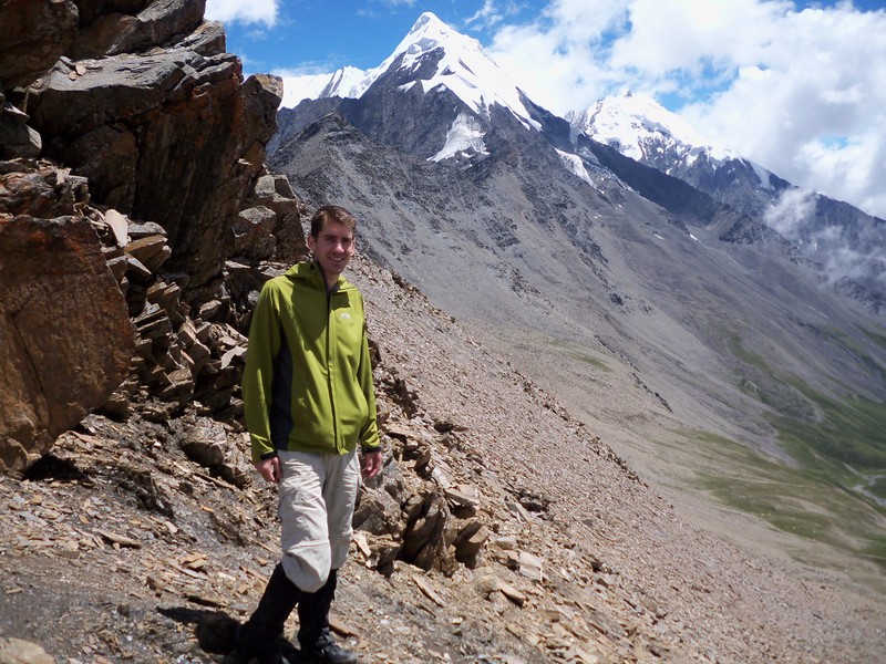
Hailou Valley Glacier
4 miles of hiking • 0' elevation gain •
During National Day (Chinese, one week off) my friend and I headed to western Sichuan, China to test out my new camera (Canon 50D, with 17-40mm) and avoid boredom. We left the town of Moxi, and rode the tourist bus for one hour up to the trailhead/cable-car. We chose to walk (the cable car will take you to a bluff with some Buddhist building and viewing pavilion, not accessible by foot). Moderate uphill through temperate forest very similar to western Washington and Oregon. After passing a viewing platform you head downhill a short way until you step onto Hailou Valley Glacier. It is continually swarming with Chinese tourists. You can rent a traditional minority outfit to take pictures in. The footing is often slippery. You are only permitted to ascend, maybe, 200-300 yards. After that the crevaces become treacherous: tall, steep, narrow ledges. If the clouds clear out, you can see the mountains ahead. But, the best view of the cascading upper glacier can only be seen by taking the cable-car.
Another valley heading north back to Kangding (capital of the prefecture or county) has rugged crags from which a river of red covered rocks (algae, or other nitrogen creating life, I think).
October 5, 2011

Rattlesnake Ledge
4 miles of hiking • 0' elevation gain •
Hiked Rattlesnake Ledge with family. Easy, with great views from Seattle to the Cascades. Rattlesnake Lake was beautiful and warm.
August 17, 2011

Twin Falls
3 miles of hiking • 0' elevation gain •
Followed up Rattlesnake Ledge with this little one. Easy hike to see a tall waterfall. But, we went off the spur to see the upper falls. Didn't do small side trip to see main one. Much of trail follows a small river.
August 17, 2011
 2
2
Timberline Trail
42 miles of hiking • 0' elevation gain • 2 nights
pics now on flickr: pieterpan
The Timberline Trail is another rough one. Now up to about 42 miles due to going around the Eliot washout, which adds about a mile heading up soft soil to the glacier, crossing it, then descending similar material. Don't even try the old trail where it is closed. It drops off a tall cliff after you burrow through very overgrown, low trees. Lots of steep snow patches and glaciers to stomp your way across. Some steep washouts. Bushwhack a short ways to connect the trail the big canyon a couple miles east of Timberline Lodge, since the former one disappears off a cliff.
The good: Waterfalls (Ramona, and many from glaciers), four in the valley of Muddy Creek, where there is a very small flat spot in the middle ridge for a one-person tent/tarp. Slept there with views of Mt. Hood's glaciers and waterfalls behind me, and the sun setting over the foothills to the west. Sunset from the shelter west of Eliot drainage is amazing! You can see St. Helens, Rainier, and Adams together with the low clouds skirting them. As the sun sets the clouds turn pink while the sky is a rainbow of blue, green, yellow, salmon and red. All of this reflecting on the mountains. Just south of this you can see Jefferson, the Sisters, and Bachelor in a row.
I tried out my new Oware tarp with the Gossamer Gear backpack (used first on St. Helens). I'm guessing total out-of-skin weight to be around 8 lbs. Fully loaded it looks like a 2/3 full day-pack. I keep wondering if I am missing something. Makes these rough hikes easier than with a heavy load.
Will load these and St. Helens pics on flicker another day.
August 7 – August 9, 2011
 2
2
Mt. St. Helens Loop
33 miles of hiking • 0' elevation gain • 1 night
pics now on flickr: pieterpan
Started from June Lake (pond) headed for the Loowit Trail, which encirlces Mt. St. Helens. Climbed over the Worm Flows heading west. This was slow. After crossing Monitor Ridge climbing route the trail exits the forest. From here until the Restricted Area there were a lot of steep snowbanks to cross. When the trail leveled out I switched to sandals, which was foolish, because I had the worst snowbanks ahead. No water sources from Butte Camp Trail to South Fork Toutle River.
Descending to the SFTR and ascending out of the gully is treacherous. After the following lightly forested area is a long section along a sandy bank of the gully. Really, you are hundreds of feet above the river on a trail that is less than a foot wide that is sand and pea gravel. After getting to the top, you are almost in the Restricted Area; a flat area with good views that has space for camping (outside the RA, of course).
The north side is broad, and desert-like. The center of that, the main path of destruction has almost no plants, just varying colors of basalt and other volcanic rock. You can take a side trail to the Toutle Falls. Crossing this area goes from lupine covered slopes, a sharp line where it changes to stark, then back again.
The eastern side has the Plains of Abraham, which is good for mountain biking. There are many gullies, but some have interesting waterfalls from snowmelt falling a good distance to a deeper gully.
At many points you can see Mt. Rainier, the North Cascades National Park peaks, Mt. Adams, and Mt. Hood. Since I got moving at 7 am the second day, I saw elk tracks, and smelled fairly fresh droppings. I was surprised to discover a herd of 20, which was joined by 10 more soon thereafter. Later I came upon a herd of 130, and 20 more further away. 180 elk in one morning! This trail was full of surprises. The first day was rough, and slow going. The terrain overall contains all the above, and old growth forests. Fantastic journey!
Will comment later when I add pics to flickr
August 3 – August 4, 2011

Watchman Peak
1.5 miles of hiking • 0' elevation gain •
Fun hike. Leads to the watchman tower overlooking Crater Lake. Short, but much of the trail is still under snow, creating a steep, somewhat slushy bank you cut steps into. Great panoramic shots. If it wasn't a little hazy, could have seen to Mt. Shasta, but we saw to the Kalamath Basin.
July 31, 2011

Whitehorse Falls
1 miles of hiking • 0' elevation gain •
Whitehorse Falls is 272 feet, fourth highest in Oregon. Amazing! Looks a bit like Multnomah, but all one freefall. Lots of vegetation I have not seen elsewhere.
July 31, 2011

Toketee Falls
1 miles of hiking • 0' elevation gain •
Fantastic falls cutting through volcanic rock. Cute viewing platform.
July 31, 2011

Cleetwood Cove
2 miles of hiking • 0' elevation gain •
This is the trail that leads to the shore of Crater Lake. Lots of people leaping into the lake from the cliff. Lake was beautiful, as usual.
July 30, 2011

Plaikni Falls
2.5 miles of hiking • 0' elevation gain •
Newly built trail off Pinnacles Road, which is a spur off of the Rim Road at Crater Lake. Very level hike to a beautiful falls and cascades. My aunt thought it looked like a small Ramona Falls.
Listed this as 2.5 miles, even though 2.2 because Cleetwood Cove was also 2.2, so the extra 0.4 has to get in somehow.
July 30, 2011

Ruckel Ridge to Eagle Creek
9 miles of hiking • 0' elevation gain •
You can find the info on other pages or trip reports. Had fun. Nice hike.
July 26, 2011

St. Edwards State Park
2.5 miles of hiking • 0' elevation gain •
Hiked a few short trails in the park down to Lake Washington and back to the house.
July 22, 2011

IAT-from Fawn Ave
1.5 miles of hiking • 0' elevation gain •
Ice Age Trail from Fawn Ave. heading toward Mondeaux Dam. First, headed west toward Mondeaux. The grass was tall, resulting in often finding ticks on my pants. A large spiders dropped in on my shoulder. After only a quarter mile or so, a large, deep mud puddle appeared, covering the entire area around the path. The upcoming mud and more deep grass, and swarms of skeeters, convinced me to turn around (my footwear was not appropriate for the mud). I headed east, and the trail looked more like I hoped. Short grass and open forest. Followed to the road, and walked on gravel back to the car. I decided going to visit my grandma was a better use of my afternoon. Found a bear tick (the small, diseased kind) and another wood tick on me at her house. I am not properly attired for Wisconsin yet.
July 12, 2011

Wisconsin's Highest Point
5 miles of hiking • 0' elevation gain •
Timm's Hill is Wisconsin's highest point at 1951.5 feet. Impressive, I know. There are a couple small lakes and a handful of ski trails to hike. Very cute lakes. There is a lookout tower at the top of the hill, so you can see over the top of the trees. Viewing distance is very far Pics on Flickr: pieterpan.
July 11, 2011

North Country Trail, Doughboy and Red Granite Falls Trail
7.5 miles of hiking • 0' elevation gain •
Hit a few small trails in Copper Falls State Park, Wisconsin. The North Country Trail passes through. Lovely little hike (2 miles, partly out and back) through forest containing very old Lodgepole and Eastern White Pines, with Sugar Maple saplings glowing in the evening light. That was a spur off of the Doughboy Trail which is a Y-shaped encircling interpretive path passing Copper and Brownstone Falls. Not very big falls, but very interesting geologic history in this Lake Superior region, what with several types of stone (Red/black lavas, granite, conglomerate, shale).
The Red Granite Falls (Trail 2.5 miles) are really cascades over red granite, obviously. Some of this is eroded into rounded boulders, some is still sharp rectangles. Trail is next to Loon Lake, a very picturesque place to swim, kayak, and fish.
Pics on Flickr: pieterpan
July 8, 2011

Pine Line (Rail) Trail-Medford
11 miles of hiking • 0' elevation gain •
Pine Line Trail is a 26.2 mile rail trail from Medford to Prentice, Wisconsin, region of my birth. I did an out-and-back from Whittlesey to Medford (the lower 5.5 miles of it). Blue skies, hay drying in the fields, red-winged black birds on the side. Just too many horse flies at the north end. Black River gains size along the way. Best for bike riding, snowmobiling and ATV's.
July 2, 2011

IAT-East Lake
8 miles of hiking • 0' elevation gain •
Started from wayside on HWY 13. Rolling trail along eskers, passing by headwaters of Black River (creek by my description). East Lake listed as 3.2 miles. I passed a marsh or pond, then two more ponds, or lakes depending on definition. Then I kept going. Based on pace and time, certainly I had passed the listed distance. Since no signage by lakes, didn't realize I had passed East Lake. Turned into 4 miles each way. No great views. Saw 4 grouse and two wild turkeys. They were big.
June 27, 2011

IAT-Mondeaux Dam
4 miles of hiking • 0' elevation gain •
Ice Age Trail in Taylor Co., Wisconsin, from Mondeaux Dam Picnic area to Picnic Point Picnic Ground. Estimating 2 miles each way. Read a couple of the interpretive signs, pointing out the ice age impacts on the geography. Quite clear to see it. Nice flowage, some interesting trees, wild strawberries, 2 squirrels, 1 goldfinch, and 1 deer. Trail is along an esker (the ridge of deposit that the caves and streams in a glacier leave), pleasant if you are prepared for the usual insects.
June 25, 2011

Cuc Phuong National Park, Vietnam
7 miles of hiking • 0' elevation gain •
Vietnam's first national park. In winter it is devoid of people and animals. There are nature walks, but only trees. It also has a primate rehab center with very short, uninformative guided tours. There is a cave where people used to live long ago (maybe prehistoric), and a few very big trees (for Asia).
January 30, 2011

MacLehose Trail
40 miles of hiking • 0' elevation gain • 2 nights
From Kowloon to reservoirs, white-sand beaches, mountains; it is great. If you don't bring enough food/water you can purchase from vending machines. Just will cost a lot. I couldn't finish the third, and final, day of the trail because I drank untreated water, and ran out of food far from next rest stop. It's a 100 km trail that is a different Hong Kong than most visitors know. Pics on flickr: pieterpan.
January 23 – January 25, 2011

Hong Kong Trail
10 miles of hiking • 0' elevation gain • 1 night
Didn't want to spend another expensive night in hotel, so I hiked until I found a little picnic area to camp. Hiked a couple sections that run next to a park at the top of a hill that is a short, steep hike, or a bus ride away from downtown. Birds singing in morning was nice.
January 22 – January 23, 2011

Stone Forest
3 miles of hiking • 0' elevation gain • 1 night
Pics on flickr: pieterpan. Arrived at Stone Forest in Yunnan Province in evening after hitching a ride in a black Audi (usually inhabited by rich guys driving like hell on wheels, sending pedestrians scattering). 20+ feet tall karst pillars in various shapes with trails winding around and through them, covering a 400+ acre area. All paths are paved (being in China). The loop surrounding the main area is wide enough for shuttles. Around each giant stone is manicured lawn, and maybe a pond. If you follow the path to the left you find an area with narrow paths through a fairly unkempt area (huzzah!). Where this path rejoins the main loop a gravel path head out left to what looks like a former western-style campground (a gutter, some amenities in disuse, a flat area with no stones; just tall grass and a few trees). If you follow this maintenance road, it leads into a small wood (There is a red banner with something in Chinese. Red is a national color, so it is hard to tell if it says "STOP!") After maybe half a mile or more you are on a small rise that enables you to see a ways. There is a sign saying not to enter or leave through a gate. This is where the local minority people enter the park to sell their wares.I found a large patch of grass to pitch my tent between the woods and the path, for a little stealth camping (tourists are always expected to stay in hotels). There is also a large area that is somewhat farmed on the north end of the park.
January 12 – January 13, 2011

Tiger Leaping Gorge
21 miles of hiking • 0' elevation gain • 1 night
Roommate, Steven, and I hiked the length of TLG in one day, and stayed overnight at a hostel. It was dry season, so the waterfalls were not as powerful as the stains on the cliffs show they will be in summer. One very steep section, but mostly even path in very deep gorge. Pics on flickr: pieterpan
January 8 – January 9, 2011
