Zoom

2016 Trips Subscribe via RSS

Heart_bw 1

Silver Star Mt via Ed's TH & Baldy via Bluff trail

9 miles of hiking • 2500' elevation gain •

Always a winner... road to Ed's still bad!

Comment 0 comments

August 6, 2016

Staticmap?size=254x125&zoom=4&maptype=terrain&markers=icon:http%3a%2f%2fwenthiking.com%2fimages%2fmarkersmall.png&key=aizasydt2ewyqnn42qqnrpazuysi2dtyerccchw&center=45.7438,-122
Heart_bw

Cape Horn

7.5 miles of hiking • 0' elevation gain •

Comment 0 comments

July 30, 2016

Staticmap?size=254x125&zoom=4&maptype=terrain&markers=icon:http%3a%2f%2fwenthiking.com%2fimages%2fmarkersmall.png&key=aizasydt2ewyqnn42qqnrpazuysi2dtyerccchw&center=45.589,-122
Heart_bw

Angels Rest to Multnomah

8 miles of hiking • 0' elevation gain •

Comment 0 comments

July 24, 2016

Staticmap?size=254x125&zoom=4&maptype=terrain&markers=icon:http%3a%2f%2fwenthiking.com%2fimages%2fmarkersmall.png&key=aizasydt2ewyqnn42qqnrpazuysi2dtyerccchw&center=45.5716,-122
Heart_bw

4T

4 miles of hiking • 0' elevation gain •

4T: Train, trail, tram, trolley. For something different we met friends downtown and took the Max train to the Zoo where we caught the trail to Council Crest, hiked to OHSU's tram, and took the trolley back into downtown.

Comment 0 comments

July 10, 2016

Staticmap?size=254x125&zoom=4&maptype=terrain&markers=icon:http%3a%2f%2fwenthiking.com%2fimages%2fmarkersmall.png&key=aizasydt2ewyqnn42qqnrpazuysi2dtyerccchw&center=45.5067,-122
Heart_bw

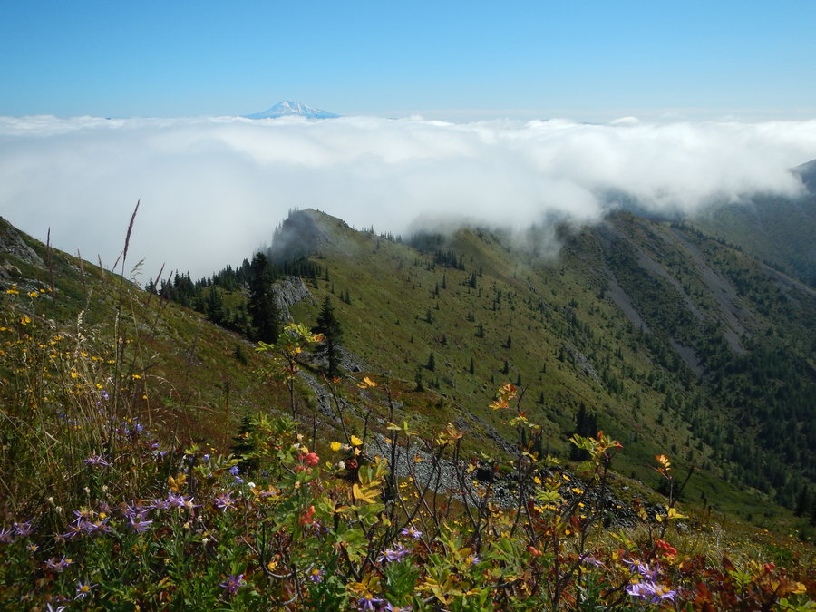
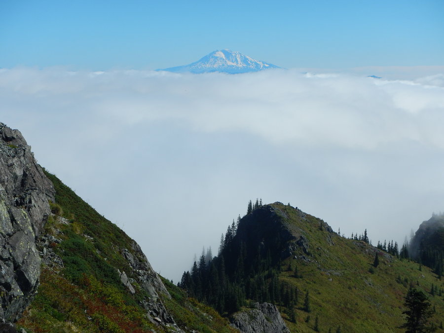
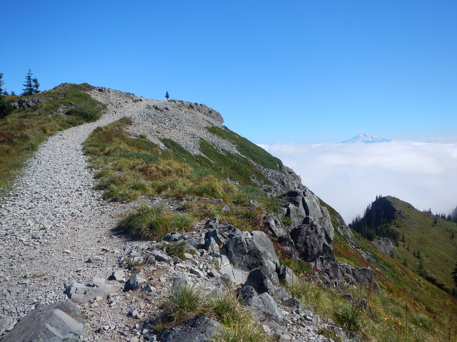
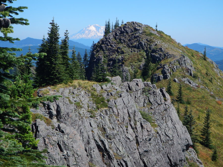
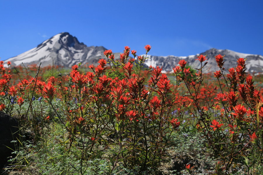
Loowit Falls from WIndy Ridge

10 miles of hiking • 2000' elevation gain •

A wonderful hike with tons of wildflowers, especially lupine and Indian paint brush. Lake and mountain views along with mountain goats up on the flanks of St Helens.

Comment 0 comments

July 2, 2016

Staticmap?size=254x125&zoom=4&maptype=terrain&markers=icon:http%3a%2f%2fwenthiking.com%2fimages%2fmarkersmall.png&key=aizasydt2ewyqnn42qqnrpazuysi2dtyerccchw&center=46.2078,-122
Heart_bw

Sahale Falls Newton Creek Loop

10.8 miles of hiking • 0' elevation gain •

Comment 0 comments

June 26, 2016

Staticmap?size=254x125&zoom=4&maptype=terrain&markers=icon:http%3a%2f%2fwenthiking.com%2fimages%2fmarkersmall.png&key=aizasydt2ewyqnn42qqnrpazuysi2dtyerccchw&center=45.3551,-121
Heart_bw

Kilauea Iki Crater Hike

4 miles of hiking • 0' elevation gain •

Comment 0 comments

June 20, 2016

Staticmap?size=254x125&zoom=4&maptype=terrain&markers=icon:http%3a%2f%2fwenthiking.com%2fimages%2fmarkersmall.png&key=aizasydt2ewyqnn42qqnrpazuysi2dtyerccchw&center=19.2908,-155
Heart_bw

McNeil Point

9.4 miles of hiking • 2250' elevation gain •

Always a good one.

Comment 0 comments

June 4, 2016

Staticmap?size=254x125&zoom=4&maptype=terrain&markers=icon:http%3a%2f%2fwenthiking.com%2fimages%2fmarkersmall.png&key=aizasydt2ewyqnn42qqnrpazuysi2dtyerccchw&center=45.3953,-121
Heart_bw

Dry Creek Falls

4.5 miles of hiking • 0' elevation gain •

Needed a quick hike we had not done before. This fit the bill.

Comment 0 comments

May 30, 2016

Staticmap?size=254x125&zoom=4&maptype=terrain&markers=icon:http%3a%2f%2fwenthiking.com%2fimages%2fmarkersmall.png&key=aizasydt2ewyqnn42qqnrpazuysi2dtyerccchw&center=45.667,-121
Heart_bw

Twin Lakes Loop

7.5 miles of hiking • 0' elevation gain •

Nice easy leg stretcher

Comment 0 comments

May 29, 2016

Staticmap?size=254x125&zoom=4&maptype=terrain&markers=icon:http%3a%2f%2fwenthiking.com%2fimages%2fmarkersmall.png&key=aizasydt2ewyqnn42qqnrpazuysi2dtyerccchw&center=45.243,-121
Heart_bw

Fall Creek Falls

8.5 miles of hiking • 0' elevation gain •

Comment 0 comments

May 7, 2016

Staticmap?size=254x125&zoom=4&maptype=terrain&markers=icon:http%3a%2f%2fwenthiking.com%2fimages%2fmarkersmall.png&key=aizasydt2ewyqnn42qqnrpazuysi2dtyerccchw&center=45.8697,-121
Heart_bw

Hummocks to Johnston Ridge Obs.

9.5 miles of hiking • 2250' elevation gain •

Comment 0 comments

April 16, 2016

Staticmap?size=254x125&zoom=4&maptype=terrain&markers=icon:http%3a%2f%2fwenthiking.com%2fimages%2fmarkersmall.png&key=aizasydt2ewyqnn42qqnrpazuysi2dtyerccchw&center=46.2872,-122
Heart_bw

Coyote Wall Labyrinth Loop

7 miles of hiking • 1500' elevation gain •

Comment 0 comments

April 2, 2016

Staticmap?size=254x125&zoom=4&maptype=terrain&markers=icon:http%3a%2f%2fwenthiking.com%2fimages%2fmarkersmall.png&key=aizasydt2ewyqnn42qqnrpazuysi2dtyerccchw&center=45.7001,-121
Heart_bw

Paradise Park Snowshoe

3.5 miles of hiking • 1000' elevation gain •

Comment 0 comments

March 26, 2016

Staticmap?size=254x125&zoom=4&maptype=terrain&markers=icon:http%3a%2f%2fwenthiking.com%2fimages%2fmarkersmall.png&key=aizasydt2ewyqnn42qqnrpazuysi2dtyerccchw&center=46.7861,-121
Heart_bw

White Pass XC Ski

5.5 miles of hiking • 500' elevation gain •

Comment 0 comments

March 25, 2016

Staticmap?size=254x125&zoom=4&maptype=terrain&markers=icon:http%3a%2f%2fwenthiking.com%2fimages%2fmarkersmall.png&key=aizasydt2ewyqnn42qqnrpazuysi2dtyerccchw&center=46.6348,-121
Heart_bw

Crater Lake XC Ski

8 miles of hiking • 250' elevation gain •

Comment 0 comments

March 4, 2016

Staticmap?size=254x125&zoom=4&maptype=terrain&markers=icon:http%3a%2f%2fwenthiking.com%2fimages%2fmarkersmall.png&key=aizasydt2ewyqnn42qqnrpazuysi2dtyerccchw&center=42.9116,-122
Heart_bw

Mt Adams XC Ski (Snow King Sno Park)

6 miles of hiking • 0' elevation gain •

Comment 0 comments

February 20, 2016

Staticmap?size=254x125&zoom=4&maptype=terrain&markers=icon:http%3a%2f%2fwenthiking.com%2fimages%2fmarkersmall.png&key=aizasydt2ewyqnn42qqnrpazuysi2dtyerccchw&center=46.0816,-121
Heart_bw

Cascade Head

4.5 miles of hiking • 750' elevation gain •

Comment 0 comments

February 13, 2016

Staticmap?size=254x125&zoom=4&maptype=terrain&markers=icon:http%3a%2f%2fwenthiking.com%2fimages%2fmarkersmall.png&key=aizasydt2ewyqnn42qqnrpazuysi2dtyerccchw&center=45.0422,-123
Heart_bw

Marble Mt. to Lava Canyon XC Ski

11.5 miles of hiking • 500' elevation gain •

Comment 0 comments

February 7, 2016

Staticmap?size=254x125&zoom=4&maptype=terrain&markers=icon:http%3a%2f%2fwenthiking.com%2fimages%2fmarkersmall.png&key=aizasydt2ewyqnn42qqnrpazuysi2dtyerccchw&center=46.1299,-122
Heart_bw 1

Trillium Lake Loop from Mazama Snopark

7.3 miles of hiking • 0' elevation gain •

Comment 0 comments

January 31, 2016

Staticmap?size=254x125&zoom=4&maptype=terrain&markers=icon:http%3a%2f%2fwenthiking.com%2fimages%2fmarkersmall.png&key=aizasydt2ewyqnn42qqnrpazuysi2dtyerccchw&center=45.2757,-121
Heart_bw

Elk Meadow snowshoe

4.8 miles of hiking • 0' elevation gain •

Comment 0 comments

January 24, 2016

Staticmap?size=254x125&zoom=4&maptype=terrain&markers=icon:http%3a%2f%2fwenthiking.com%2fimages%2fmarkersmall.png&key=aizasydt2ewyqnn42qqnrpazuysi2dtyerccchw&center=45.3388,-121
Heart_bw

Pocket Creek Ski

6.3 miles of hiking • 0' elevation gain •

Comment 0 comments

January 9, 2016

Staticmap?size=254x125&zoom=4&maptype=terrain&markers=icon:http%3a%2f%2fwenthiking.com%2fimages%2fmarkersmall.png&key=aizasydt2ewyqnn42qqnrpazuysi2dtyerccchw&center=45.3624,-121
Heart_bw

Ski up "Ramona Falls Road"

7.5 miles of hiking • 0' elevation gain •

Parked at the bridge (it is gated here) over the Muddy Fork of the Sandy and skied up to the Ramona Falls TH and then another mile up the Ramona Falls trail. We were the first ones on the trail and the snow was perfect for skiing. Passed two groups who were heading up to the falls and then another three skiing groups. The wind was surprisingly calm and temps in the 20s. Snow and winds picked up as we were returning to the bridge. All in all one of the best skis we have had.

Comment 0 comments

January 3, 2016

Staticmap?size=254x125&zoom=4&maptype=terrain&markers=icon:http%3a%2f%2fwenthiking.com%2fimages%2fmarkersmall.png&key=aizasydt2ewyqnn42qqnrpazuysi2dtyerccchw&center=45.3847,-121
Heart_bw 1

Tillamook Head National Recreation Trail

8 miles of hiking • 0' elevation gain •

Wanted to avoid the subzero windchill in the mountains so headed to the relatively balmy coast. Hiked 7.0 miles RT starting from Seaside, a little short of the camp / WWII bunker. The trail was really thrashed from recent storms with lots of blow down and two major landslides. Other than bushwhacking through two blown down areas the trail was not terribly difficult with easy routes around the slides. Some filtered views but nothing spectacular, IMO.

Comment 0 comments

January 1, 2016

Staticmap?size=254x125&zoom=4&maptype=terrain&markers=icon:http%3a%2f%2fwenthiking.com%2fimages%2fmarkersmall.png&key=aizasydt2ewyqnn42qqnrpazuysi2dtyerccchw&center=45.9734,-123

View trips from: 2015 2016